
Highest elevation 256 m (840 ft) Elevation 256 m | Highest point (unnamed) Area 5.7 km² | |
 | ||
Island groups Tuamotu-Gambier Islands, Tuamotus, Gambier Islands | ||
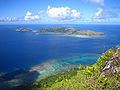
Taravai is the second largest island in the Gambier Islands of French Polynesia, at 5.7 km². Taravai is about 1.5 km southwest of Mangareva and about 300 m north of the island of Angakauitai. Off its eastern shore lies the tiny rock Îlot Motu-o-ari.
Map of Taravai
The village named Agonoko is located near the main bay on the island's eastern shore. It has a population of 9 (as of 2012). Former villages were Aga-nui (northwest) and Agakau-i-uta (southeast).
The Onemea archaeological site suggests sporadic occupation of the island around AD 950 with a possible continuous settlement since the 13th century.
Before the conversion to Christianity, the king of Taravai was a vassal to the king of Rikitea in Mangareva.
References
Taravai Wikipedia(Text) CC BY-SA