
Basin countries United States Area 1,600 km² | ||
 | ||
Surface area 600 square miles (1,600 km) River sources | ||
Galveston bay fishing map
Galveston Bay (/ˈɡælvᵻstən/ GAL-viss-tən) is the 7th largest estuary in the United States, located along the upper coast of Texas. It is connected to the Gulf of Mexico and is surrounded by sub-tropic marshes and prairies on the mainland. The water in the Bay is a complex mixture of sea water and fresh water which supports a wide variety of marine life.
Contents
- Galveston bay fishing map
- Map of Galveston Bay Texas USA
- History
- Features
- Ecosystem
- Urban development
- Climate
- Pollution
- References
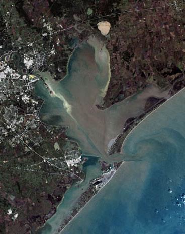
Map of Galveston Bay, Texas, USA
The bay has been historically important during Texas' history. The island of Galveston was home to eastern and coastal Texas' earliest major settlement and, during the later 19th century, it was Texas' largest city. The island's port, on the bay side, became one of the top ports in the U.S. During the 20th century as the oil boom in Texas took hold the bay became even more important as a shipping center as Houston and Texas City developed into major port and industrial centers.
Today the bay is within the Houston–Sugar Land–Baytown metropolitan area, which is the fifth-largest metropolitan area in the U.S. and is home to major ports including the second-busiest port in the nation. It produces more seafood than any bay in the nation except the Chesapeake.
History
The Gulf Coast gained its present configuration during the last ice age. Approximately 30,000 years ago sea levels fell dramatically as water was incorporated into vast ice sheets. The Trinity and San Jacinto rivers carved wide valleys into the soft sediments, especially along the modern coastline. Gradual melting of the ice sheets as the ice age ended filled the valleys with water creating the bay system approximately 4,500 years ago. Sea level rise reached a relative peak approximately 4,000 years ago giving the bay its present form.
Human settlement in what is now Texas began at least 10,000 years ago following migrations into the Americas from Asia during the last ice age. The first substantial settlements in the area are believed to have been the Karankawa and Atakapan tribes, who lived throughout the Gulf coast region.
Though several Spanish expeditions charted the Gulf Coast, it was explorer José Antonio de Evia who in 1785 gave the bay and the island the name Galvezton in honor of the Spanish Viceroy Bernardo de Gálvez. Louis Aury established a naval base at the harbor in 1816 to support the Mexican Revolution. His base was soon appropriated by the pirate Jean Lafitte who temporarily transformed Galveston Island and the bay into a pirate kingdom before being ousted by the United States Navy.
Following its independence from Spain the new nation of Mexico claimed Texas as part of its territory. Settlements were established around the bay, particularly Galveston and Anahuac, as well as Lynchburg and San Jacinto. Following growing unrest, Texas revolted and gained independence in 1836 at the Battle of San Jacinto, near the bay along the San Jacinto River. The new Republic of Texas grew rapidly and joined the United States in 1845. The bay would gain notoriety for war one last time during the naval combat of the Battle of Galveston, part of the Civil War which Texas ultimately lost.
Reconstruction was swift in southeast Texas. Ranching interests were major economic drivers on the mainland in the 19th century. The city of Galveston became a major U.S. commercial center for shipping cotton, leather products and cattle, and other goods produced in the growing state. Railroads were built around the shore and new communities continued to emerge. Commercial fishing developed as a substantial industry, particularly oysters, finfish, and later shrimp. By the end of the 19th century the inland city of Houston had begun to emerge as an important competitor to Galveston as dredging in the bay made it a viable port.
The Galveston Hurricane of 1900 devastated the city of Galveston and heavily damaged communities around the bay. Growth moved inland to Houston as fear of the risks posed by establishing businesses at Galveston limited the island's ability to compete. Texas City emerged as another important port in the area. Shipping traffic through the bay expanded dramatically.
The Texas oil boom began in 1901 and by 1915 oil production by the bay was fully underway. Oil wells and refineries quickly developed throughout the area. Wealth emerged in the area as never before. Industrialization and urbanization led to the pollution of the bay. By the 1970s the bay was described by some sources as "the most polluted body of water in the U.S." The ship channel and Clear Lake were rated by some sources as having even worse water quality. Drilling for oil and underground water, as well as large wakes from increasing shipping in the bay, led to land subsidence and erosion along the shoreline, especially in the Baytown-Pasadena area. Today approximately 100 acres (0.40 km2) of the historic San Jacinto battleground are submerged, most of Sylvan Beach is gone, and the once prominent Brownwood neighborhood of Baytown has had to be abandoned.
The establishment of NASA's Johnson Space Center near the bay in the Clear Lake Area in 1963 brought new growth. By the 1970s Houston had become one the nation's largest cities and its expansion connected it with the bay communities. The bay's shoreline became heavily urbanized. The bay and the communities around it gradually emerged as major recreational destinations.
Hurricane Ike struck the bay in 2008 causing substantial damage both environmentally and economically, the most destructive event since 1900. As of 2009 a proposal to build a levee system, the Ike Dike, to protect the bay is under discussion.
Features
The Galveston Bay system consists of four main subbays: Galveston Bay proper (upper and lower), Trinity Bay, East Bay, and West Bay. The Bay is fed by the Trinity River and the San Jacinto River, numerous local bayous and incoming tides from the Gulf of Mexico. Many smaller bays and lakes are connected to the main system such as Christmas Bay, Moses Lake, Dickinson Bay, Clear Lake, Ash Lake, Black Duck Bay, and San Jacinto Bay. The Bay covers approximately 600 square miles (1,500 km²), and is 30 miles (50 km) long and 17 miles (27 km) wide. Galveston Bay is on average 7–9 feet (3 m) deep.
The bay has three inlets at the Gulf of Mexico: Bolivar Roads (the exit of the Houston Ship Channel) between Galveston Island and the Bolivar Peninsula, San Luis Pass to the west, and Rollover Pass to the east. The Gulf Intracoastal Waterway, a navigable waterway consisting of natural islands and man-made canals along the Gulf Coast, runs between the Bay and the Gulf. It effectively marks the boundary between the two."NOAA Chart".
Ecosystem
This unique and complex mixing of waters from different sources provides nursery and spawning grounds for many types of marine life including crabs, shrimp, oysters, and many varieties of fish thereby supporting a substantial fishing industry. The deeper navigation channels of the bay provide suitable habitats for bottlenose dolphins, which feed on the abundant fish varieties. Additionally the system of bayous, rivers, and marshes that ring the Bay support their own ecosystems allowing for diverse wildlife and enabling freshwater farming of crawfish.
The wetlands that surround the Bay support a variety of fauna. Notable land-dwelling species include the American alligator and the bobcat, while notable bird species include the yellow rail, and purple gallinule, and the pelican.
Urban development
Galveston Bay is located in the Greater Houston metropolitan area and itself is at the center of one of the most important shipping hubs in the world. The metro area is the fifth-largest metropolitan area in the United States with a population of 6.1 million as of the 2010 U.S. Census estimate. The population of the metropolitan area is centered in the city of Houston—the largest economic and cultural center of the American South with a population of 2.2 million. It is among the fastest-growing metropolitan areas in the United States.
Four counties border the Bay: Brazoria, Chambers, Harris, and Galveston County. The largest city in this area is Houston, the nation's fourth-largest. Houston itself, though, began its life as an inland city and only due to its immense growth has it reached the shores of the Bay. The area's original metropolis was Galveston, which though now largely a quiet, tourist island, was once one of the most important ports in the nation prior to the 1900 Galveston hurricane. Other significant communities bordering the Bay include Texas City, Pasadena, Baytown, and Anahuac.
Important ports that serve the bay include the Port of Houston, the Port of Texas City, and the Port of Galveston. The Houston Ship Channel, which connects the Port of Houston to the Gulf, passes through the Bay. It is a partially man-made feature created by dredging the Buffalo Bayou, the ship channel subbays, and Galveston Bay.
The area has a broad industrial base including the energy, manufacturing, aeronautics, transportation, and health care sectors. Houston is second to only New York City in the number of Fortune 500 headquarters in the city limits. The bayside communities in particular are themselves the heart of both the nation's manned space program and the nation's petrochemical industry.
Climate
The climate around the Bay is classified as humid subtropical (Cfa in Köppen climate classification system). Prevailing winds from the south and southeast bring heat from the deserts of Mexico and moisture from the Gulf of Mexico.
Summer temperatures regularly exceed 90 °F (32 °C) and the area's humidity drives the heat index even higher. Winters in the area are temperate with typical January highs above 60 °F (16 °C) and lows are near 40 °F (4 °C). Snowfall is generally rare. Annual rainfall averages well over 40 inches (1,000 mm) a year with some areas typically receiving over 50 inches (1,300 mm).
Hurricanes are an ever-present threat during the fall season. Galveston Island and the Bolivar Peninsula are generally at the greatest risk. However, though the island and the peninsula provide some shielding, the bay shoreline still faces significant danger from storm surge.
Pollution
The Bay receives the fourth highest level of toxic chemicals in the state from bayside industrial discharge, in addition to pollutants washing in from the Houston Ship Channel. Though concerns have been raised about the safety of seafood obtained from the Bay the Texas Department of Health have stated that fish from the Bay is "safe for unlimited consumption."
Excessive ozone levels can occur due to industrial activities; nearby Houston is ranked among the most ozone-polluted cities in the United States. The industries located along the ship channel are a major cause of the pollution.
On March 22, 2014, a barge carrying nearly a million gallons of marine fuel oil collided with another ship in the Houston Ship Channel, causing the contents of one of the barge's 168,000-gallon tanks to leak into Galveston Bay.