
Bridges Sidney Sherman Bridge | Length 85 km | |
 | ||
Basin size 500 square miles (1,300 km) Tributaries Left:Mayde Creek, Turkey Creek, Rummel Creek, Spring Branch, White Oak Bayou, Hunting Bayou, Greens Bayou, San Jacinto RiverRight:Brays Bayou, Sims Bayou, Vince Bayou Similar Buffalo Bayou Park, Houston Ship Channel, White Oak Bayou, Terry Hershey Park, Hermann Park | ||
Buffalo Bayou is a slow-moving river which flows through Houston in Harris County, Texas. Formed some 18,000 years ago, it has its source in the prairie surrounding Katy, Fort Bend County, and flows approximately 53 miles (85 km) east through the Houston Ship Channel into Galveston Bay and the Gulf of Mexico. In addition to drainage water impounded and released by the Addicks and Barker reservoirs, the bayou is fed by natural springs, surface runoff, and several significant tributary bayous, including White Oak Bayou, Greens Bayou, and Brays Bayou.
Contents
- Map of Buffalo Bayou Texas USA
- Drone footage of houston flooding buffalo bayou park
- Route
- History
- Role of the watershed
- References
Map of Buffalo Bayou, Texas, USA
As the principal river of Greater Houston, the Buffalo Bayou watershed is heavily urbanized. Its 102-square-mile (260 km2) direct drainage area contains a population of over 440,000. Including tributaries, the bayou has a watershed area of approximately 500 square miles (1,300 km2).
Drone footage of houston flooding buffalo bayou park
Route
The upper watershed of Buffalo Bayou is impounded by the Addicks and Barker reservoirs, which comprise a major flood control system for the region. The reservoir system plays a crucial role in delaying and attenuating the peak outflow of the river during large rainfall events. Moving eastward, the Buffalo flows under State Highway 6 and into Terry Hershey Park, a linear park which follows the bayou for approximately 6 miles (9.7 km), culminating at Beltway 8. Jogging, biking, kayaking, and fishing are popular in this area.
The bayou meanders around the Memorial Villages between Beltway 8 and Loop 610. There is less public access to this stretch, since most of the land on either side is privately owned.
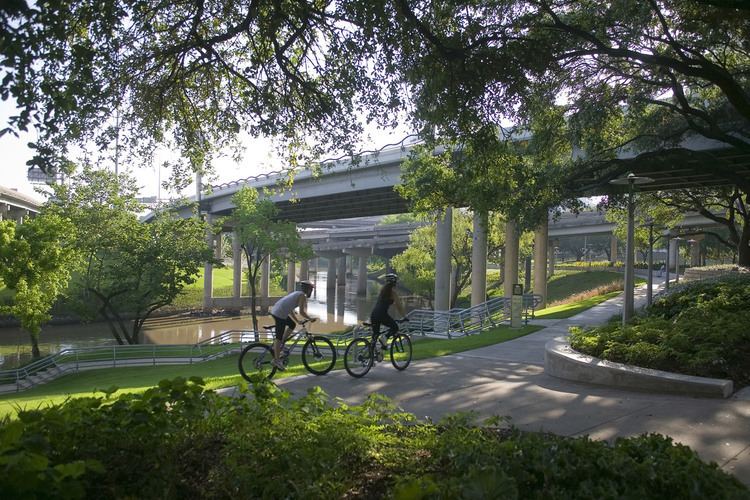
On the east side of Loop 610, Buffalo Bayou passes along the south side of Memorial Park and the north side of River Oaks Country Club, and is once again accessible to the public. Bayou Bend Collection and Gardens, the former estate of Houston philanthropist Ima Hogg, is located on the north bank of the bayou just east of Memorial Park. After passing under Shepherd Drive, the waterway enters Buffalo Bayou Park, which is bordered on the north by Memorial Drive and the south by Allen Parkway. The park continues for 2.3 miles (3.7 km) to Interstate 45, where it enters Downtown Houston. The bayou flows past Allen's Landing and joins White Oak Bayou before exiting the central business district at Interstate 69. The bayou widens considerably as it travels through the East End, culminating at the Houston Ship Channel.
History
Along with Galveston Island and Galveston Bay itself, Buffalo Bayou was one of the focal points for early Anglo-American settlement in early Texas, first part of the Spanish Empire and then part of Mexico. Early communities began to appear at the beginning of the 19th century, including Lynchburg, Harrisburg, and New Washington (modern Morgan's Point) in the 1820s. The bayou became important in Texas history when the final battle for Texas Independence was fought along its banks where it merges with the San Jacinto River.
In the 1830s, new communities such as Houston were established along the shoreline. A local entrepreneur named Samuel Allen (unrelated to the founders of Houston) established a large ranch, later known as the Allen Ranch, between Harrisburg and Galveston Bay. Docks at Harrisburg, Houston, and the Allen Ranch gradually became the foundations of what would become the modern Port of Houston. Harrisburg served as the region's major trade center until the 1870s, when a large fire destroyed its railroad facilities, which were subsequently rebuilt in Houston.
Houston's original docks were established at the foot of Main Street at the confluence of Buffalo Bayou and White Oak Bayou in an area of downtown Houston today known as Allen's Landing. At that time this was the most westerly location a small trading schooner could turn around. This site is now a public park and is adjacent to the University of Houston–Downtown.
Buffalo Bayou and Galveston Bay were dredged during the late 19th and early 20th centuries to accommodate larger ships. By the mid-1900s the Port of Houston had established itself as the leading port in Texas, eclipsing the natural harbors at Galveston and Texas City. The Turning Basin terminal in Harrisburg (now part of Houston) became the port's largest shipping point. The Texas oil boom of the early 20th century sparked industrial development along Buffalo Bayou east of Houston and along Galveston Bay.
Following the passage of the Clean Water Act in 1972, Houston sought to address the untreated sewage that was being discharged into the bayous. The city has invested over $3 billion into new sewers, pumping stations, and sewage treatment plants across the metropolitan area, which has significantly improved water quality in the region.
In 1977, Barbours Cut Terminal was opened at Morgan's Point, shifting shipping traffic away from the Turning Basin. Commerce on the bayou remains vital to the economy of Greater Houston.
In 1986, a mayor-appointed task force published the first Buffalo Bayou Master Plan, which outlined a vision for the bayou that took it from being an urban sewer to being a valuable natural resource and valuable park space and rich with urban waterfront opportunities. The Buffalo Bayou Partnership was created from this original task force in 1986 and in 2002 they published the Buffalo Bayou and Beyond Master Plan, an updated and comprehensive regional bayou restoration and economic development program expected to cost $5.6 billion and take 20 years to implement. The project goals include the creation of hundreds of acres of greenways and new parks by reclaiming industrial space along the bayou waterway, habitat restoration program, recreational opportunities for canoeing and kayaking, trails for hiking and biking, outdoor cultural events, watershed and flood control management, and mixed-use urban development.
The Buffalo Bayou Partnership has raised more than $45 million from private donors and foundations to implement specific projects along the bayou, including efforts to develop continuous trails along the bayou. The most recent segment of the Buffalo Bayou trail system to be completed is the $15 million Buffalo Bayou Promenade, which extends from the historic Sabine Street bridge just west of Downtown to Bagby Street in the heart of the Theater District. This new 23-acre (93,000 m2) recreation area, complete with 1.4 miles (2.3 km) of hiking and biking trails, was opened in 2006.
The Buffalo Bayou Promenade has become a popular location for live performances of music and video, for outdoor sculpture exhibits (The Buffalo Bayou Art Park), for canoeing and kayaking and for walking and jogging. The promenade has won local and national acclaim for the role it has played in helping to change how Houstonians think about their waterways in general and Buffalo Bayou in particular.
Today, despite the urban environment, Buffalo Bayou and its parks remain the centerpiece for many festivals and gatherings in Houston throughout the year. It is also still very popular with canoe and kayak enthusiasts.
Role of the watershed
The 103-square-mile (270 km2) Buffalo Bayou watershed is central to the drainage of Houston and Harris County. Lying over relatively impervious soils and very flat topography, the bayou has extensive natural floodplains, as do most Gulf coastal rivers and streams. The gradual urbanization of the watershed, starting with the founding of the city in 1836 and accelerating in the latter half of the twentieth century, placed thousands of people in the natural floodplains. At the same time, changes to the watershed due to urbanization increased the level and intensity of flood events.
Responding to disastrous flood damages due to floods in the 1930s, the U.S. Army Corps of Engineers in association with the Harris County Flood Control District, began numerous projects to reduce Houston’s flooding risks through an extensive program of reservoir construction, removal of stream-bank vegetation, straightening, and deepening channels and lining them with concrete.
In the 1960s, Terry Hershey, working with local congressman George Herbert Walker Bush, prevented the federal government from bulldozing and channelizing Buffalo Bayou inside of Beltway 8. In 1966, Hershey and a number of other homeowners in Houston’s Memorial Villages area formed the Buffalo Bayou Preservation Association, which later widened its mission and became the Bayou Preservation Association. While the quality of water has remained an issue, the bayou was one of the few in the Harris County flood district to retain its natural riparian ecosystem.