
Reference no. DE: 244 Length 135 km | Source elevation 390 m | |
 | ||
The Franconian Saale (German: Fränkische Saale) is a 125 km long river in Bavaria, Germany. It is a right-bank tributary of the Main, in Lower Franconia. It should not be confused with the larger Saxon Saale (German: Sächsische Saale), which is a tributary of the Elbe River.
Contents
- Map of Franconian Saale Germany
- Headwaters
- Course and mouth
- Catchment area
- Name
- Ecology
- Fauna
- Flooding
- Gauging stations
- Tributaries
- Municipalities on the Franconian Saale
- Castles in the Saale valley
- Bridges over the Saale
- Weirs
- Boating
- The Saale Valley Railway
- References
Map of Franconian Saale, Germany
The Fränkische Saale flows through Bad Königshofen, Bad Neustadt, Bad Kissingen, Hammelburg and flows into the Main River in Gemünden am Main.
Headwaters
The Franconian Saale begins in the region of Grabfeld east and southeast of Bad Königshofen at the confluence of two headstreams:
The names of the two headstream sources indicate that they both claim to be the source of the Franconian Saale itself. A possible third source is Brennhausen.
Course and mouth
From the confluence of its headwaters, south-east of Bad Königshofen, the Franconian Saale flows in a broadly southwesterly direction along the southeastern edge of the Rhön Mountains. It passes through Bad Neustadt, Bad Bocklet, Bad Kissingen, Hammelburg and Gräfendorf to Gemünden, where it joins the River Main from the northeast.
Catchment area
The water catchment area of the Franconian Saale is 2,765 km2. Its kilometrage is measured from its confluence with the Main (0.00 km on the Saale, 211.0 km on the Main) to its more distant source at Alsleben (135.0 km).
Name
The Franconian Saale is mentioned for the first time in the year 777 under the names Salu and Sala in a register from the town of Fulda. These terms both have the general meaning of "flowing waters" and had already been documented by the Greek geographer, Strabo (ca. 63 b.c.–a.d. 23).
Ecology
The Franconian Saale has been altered by man for centuries in order to farm the Saale valley more intensively. The river was straightened by cutting across its meanders. The width of the river has also been standardized for long sections. Riparian forests were cleared and its banks reinforced, water mills and small hydropower stations and weirs were built and former flood zones were built on.
All this has seriously affected the ecological function of the river. Embankments and dams change its flow rate and consistency (Durchgängigkeit), destroying the unity of the river and meadow and encouraging devastating flooding. For several years the water authority in Schweinfurt has instigated projects to try, at least in part, to return the Franconian Saale to its former ecological role by removing bank reinforcements, circumnavigating weirs and regenerating riparian woodland.
Fauna
The Franconian Saale is a habitat for the European eel, Chub, Ide, Grayling, Brown trout, Stone Loach, Barbel Bitterling, Bream, Minnow, Perch, Gudgeon, Dace, Pike, Ruffe, Bullhead, Nase, Roach, Rudd, Burbot and Carp, as well as the occasional Signal crayfish.
Flooding
Towns and villages close to the Saale that are particularly affected by regular flooding are Bad Kissingen, Westheim, Diebach, Gräfendorf, Wolfsmünster and Gemünden, as the highwater marks on historic buildings show. Bad Kissingen rarely escapes several flooding each year. However, flood protection measures involving the construction of weirs and defensive barriers have been implemented in its historic town centre.
Gauging stations
Gauging stations are located in Bad Kissingen (the Prinzregentenbau Gauge) and Wolfsmünster (Saale Bridge Gauge). The measurements are published by the Schweinfurt Water Authority (Wasserwirtschaftsamt Schweinfurt).
Tributaries
After the confluence of the two headstreams the following tributaries flow into the Franconian Saale:
A comprehensive list including the smaller tributaries is in the List of tributaries of the Franconian Saale (German).
Municipalities on the Franconian Saale
The Franconian Saale flow through or past the following municipalities:
Castles in the Saale valley
There are several picturesque castles in the Saale valley:
Bridges over the Saale
Important crossings include:
Weirs
There are numerous weirs on the Franconian Saale, originally built in order to drive water mills, but today some are used to generate electricity. All weirs are equipped with fish ladders:
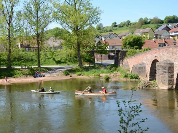
Boating
In spite of the many weirs the Franconian Saale is popular with canoeists as a slowly flowing river route. The river may be canoed from Bad Neustadt to Gemünden with a few restrictions. Boats may have up to four seats, be no longer than 6.00 metres and no wider than 1.10 metres. Rafting and the coupling of boats is not permitted.
The Saale Valley Railway
The railway line from Bad Kissingen to Gemünden via Hammelburg and Gräfendorf known as the Saale Valley Railway runs along the lower course of the Franconian Saale. Until 1997 the Grabfeld Railway ran along its upper reaches linking Bad Neustadt and Bad Königshofen.