
Admin. region Unterfranken Municipal assoc. Euerdorf Area 6.73 km² Population 888 (31 Dec 2008) | Time zone CET/CEST (UTC+1/+2) Local time Thursday 1:15 PM Postal code 97717 | |
 | ||
Weather 8°C, Wind SW at 42 km/h, 47% Humidity | ||
Aura an der Saale is a municipality in the district of Bad Kissingen in Bavaria in Germany.
Contents
Map of Aura an der Saale, Germany
Geography
Aura lies on the left bank of the Saale in Franconia about 7 km from the district capital of Bad Kissingen. It is the smallest municipality in the district.
History
A Benedictine monastery named Uragia was founded between 1108 and 113 by the Bishop of Bamberg. Starting in 1394, the monastery belonged to the Bishop of Würzburg.
With secularization of the government in 1803, the territory of the present municipality became part of Bavaria. In the Treaty of Pressburg between France and Austria in 1805, the lands of the Bishop of Würzburg were given to Ferdinand III, Grand Duke of Tuscany, and he was made Grand Duke of Würzburg, a new state, as a reward for his support of Napoleon. These lands then again became part of Bavaria in 1814 (this time permanently) at the defeat of Napoleon.
In 1817, Aura was temporarily the seat of a state court of Bavaria. The present municipality was established in 1818.
In January 2003, Aura had a major flood, with many of the streets under water.
Government
The town council has nine members, including the mayor. As of 2002, seven members were CSU and two DBB.
Coat of arms
A red cross on a silver background, with a horizontal silver grill and a gold abbot's staff.
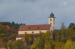
Sightseeing
St. Laurentius church was built as the monastery chapel between 1108 and 1113.