
Isolation 10.5 km (6.5 mi) Prominence 552 m | Elevation 1,408 m | |
 | ||
Similar Schrattenfluh, Pilatus, Hohgant, Rigi, Brienzer Rothorn | ||
The Napf is a mountain on the border between the Swiss cantons of Bern and Lucerne. With an altitude of 1,408 meters (4,619 ft), it is the summit of the Napfgebiet (Napf region), the hilly region lying between Bern and Lucerne. It is counted geologically as part of the Swiss plateau, although it is sometimes considered part of the Emmental Alps. The region is bounded by the Emmental to the south-west and the Entlebuch to the east. The region is traversed by the Brünig-Napf-Reuss line.
Map of Napf, 3557 Trub, Switzerland
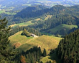
The peak is surrounded by steep hills that are a patchwork of evergreen forests and small mountain farms. Nearby towns include Romoos, Doppleschwand, Michlischwand, Luthern, and Menzberg.
References
Napf Wikipedia(Text) CC BY-SA