
Elevation 2,915 m (9,564 ft) Parent range Western Alps | ||
 | ||
Cantons ListSchwyzZugGlarusUriLuzern Topo map Swiss Federal Office of Topography swisstopo | ||
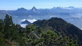
The Schwyz Alps (German: Schwyzer Alpen) are a mountain range in Switzerland. They form part of the North-Eastern Swiss Alps and are bordered by the Glarus Alps to the east, the Appenzell Alps to the north-east, the Emmental Alps in the west, and the Uri Alps to the south-west. The Klausen Pass is the highest point between the Schwyz Alps and the Glarus Alps.
The Schwyzer Alps extend beyond the boundaries of the canton of Schwyz, including parts of the cantons of Glarus, Luzern, Uri and Zug. The highest point in the Schwyzer Alps is the Glärnisch, at an elevation of 2,915 metres (9,564 ft), which actually lies within the canton of Glarus. Just south of the Glärnisch is the Bös Fulen, the highest point in the canton of Schwyz.
Principal summits
The principal summits of the Schwyzer Alps are: