The division is largely (with many exceptions) undisputed at the lowest level (except for the Ukrainian part), but various divisions are given for the higher levels, especially for the penultimate level. A geomorphological division has been used as much as the data was available; other new physiogeographic divisions were used in other cases. Where the classification of a higher level "title" is known/sure, it is added at the end of the name in brackets, e.g. "(subprovince)".
TaxonomyThe names are also given in the language of the corresponding country and marked by the ISO 3166-1 alpha-2 country codes:
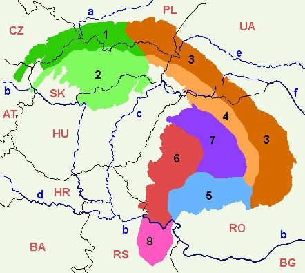
AT=AustriaCZ=Czech RepublicHU=HungaryPL=PolandRO=RomaniaRS=SerbiaSK=SlovakiaUA=UkraineThe most confusing area may be the Beskids and the Eastern Beskids and the Ukrainian Carpathians. Their geologic features are fairly distinct, but multiple traditions, languages and nationalities have developed overlapping variants for the divisions and names of these ranges.
In Romania, it is usual to divide the Eastern Carpathians in Romanian territory into three geographical groups (north, center, south), instead in Outer and Inner Eastern Carpathians. The Romanian approach is shown by adding the following abbreviations to the names of units within Romania:
MMB = Carpathians of Maramureș and Bukovina (Munții Carpați ai Maramureșului și Bucovinei)MMT = Moldavian-Transylvanian Carpathians (Munții Carpați Moldo-Transilvani)MC = Curvature Carpathians (Munții Carpați de Curbură)The Transylvanian Plateau is encircled by, and geologically a part of, the Carpathians. But it is not a mountainous region and its inclusion is disputed in some sources. Its features are included below.
The Serbian Carpathians are sometimes considered part of the Southern Carpathians (together with the Banat Mountains), sometimes not considered part of the Carpathians at all. They're included below.
The Outer Carpathian Depressions lay outside the broad arc of the entire formation and are usually listed as part of the individual divisions of the Carpathian Mountains, i.e. of Western Carpathians, Eastern Carpathians etc. With the difficulty of finding their exact subdivisions, they are given only as a list of the final units (mountains" etc.) from the west to the east and south, in a separate listing at the end.
(CZ: Jihomoravské Karpaty, AT: Österreichisch-Südmährische Karpaten)
Lower Austrian Inselberg Swell (AT: Leiser Berge, Niederösterreichische Inselbergschwelle) + Mikulov Highlands (CZ: Mikulovská vrchovina)Dyje-Svratka Vale (AT: Thaya-Schwarza Thalsenke, CZ: Dyjsko-svratecký úval)(CZ: Středomoravské Karpaty)
Ždánice Forest (Ždánický les)Litenčice Hills (Litenčická pahorkatina)ChřibyKyjov Hills (Kyjovská pahorkatina)(CZ/SK: Slovensko-moravské Karpaty)
White Carpathians (CZ: Bílé Karpaty, SK: Biele Karpaty)Maple Mountains (Javorníky) (CZ+SK)Myjava Hills (SK: Myjavská pahorkatina)Váh Valley Land (SK: Považské podolie)Vizovice Highlands (CZ: Vizovická vrchovina)(CZ: Západobeskydské podhůří, PL: Pogórze Zachodniobeskidzkie)
Sub-Beskidian Hills (CZ: Podbeskydská pahorkatina)Silesian Piedmont (PL: Pogórze Śląskie)Wieliczka Piedmont (PL: Pogórze Wielickie)Wiśnicz Piedmont (PL: Pogórze Wiśnickie)(CZ: Západní Beskydy, SK: Západné Beskydy, PL: Beskidy Zachodnie)
Hostýn-Vsetín Mountains (CZ: Hostýnsko-vsetínská hornatina)Moravian-Silesian Beskids (CZ: Moravskoslezské Beskydy, SK: Moravsko-sliezske Beskydy)Turzovka Highlands (SK: Turzovská vrchovina)Jablunkov Furrow (CZ: Jablunkovská brázda)Rožnov Furrow (CZ: Rožnovská brázda)Jablunkov Intermontane (SK: Jablunkovské medzihorie, CZ: Jablunkovské mezihoří)Silesian Beskids (PL: Beskid Śląski, CZ: Slezské Beskydy)Żywiec Basin (PL: Kotlina Żywiecka)cont. (Polish) Western Beskids (PL) (PL: Beskidy Zachodnie)
Little Beskids (Beskid Mały)Maków Beskids or Middle Beskids (Beskid Makowski or "Beskid Średni")Island Beskids (Beskid Wyspowy)Gorce(?)Rabka Basin (Kotlina Rabczańska)Sącz Basin (Kotlina Sądecka)(SK: Stredné Beskydy, PL: Beskidy Zachodnie)
Orava Beskids (SK: Oravské Beskydy) + Żywiec Beskids (PL: Beskid Żywiecki) (the older SK equivalent of Beskid Zywiecki is "Slovenské Beskydy"- Slovak Beskids or "Kysucko-oravské Beskydy"- Kysuce-Orava Beskids; the older polish equivalent is "Beskid Wysoki" - High Beskids)Kysuce Beskids (SK: Kysucké Beskydy) +Żywiec Beskids (PL: Beskid Żywiecki) (the older SK equivalent of Beskid Zywiecki is "Slovenské Beskydy" or "Kysucko-oravské Beskydy"; the older polish equivalent is "Beskid Wysoki" - High Beskids)Kysuce Highlands (SK: Kysucká vrchovina)Orava Magura (SK: Oravská Magura)Orava Highlands (SK: Oravská vrchovina)Sub-Beskidian Furrow (SK: Podbeskydská brázda)Sub-Beskidian Highlands (SK: Podbeskydská vrchovina)(SK: Východné Beskydy, PL: Beskidy Zachodnie)
Sącz Beskids (PL: Beskid Sądecki) + Ľubovňa Highlands (SK: Ľubovnianska vrchovina)Čergov (SK) + Czerchów Mountains (PL: Góry Czerchowskie)Pieniny (often considered part of the Podhôľno-magurská oblasť in non-geomorphological systems)(SK: Podhôľno-magurská oblasť, PL: Obniżenie Orawsko-Podhalańskie)
Skorušina Mountains (SK: Skorušinské vrchy) + Spiš-Gubałówka Piedmont (PL: Pogórze Spisko-Gubałowskie)Sub-Tatra Furrow (SK: Podtatranská brázda, PL: Rów Podtatrzański)Spiš Magura (SK: Spišská Magura) + Spiš-Gubałówka Piedmont (PL: Pogórze Spisko-Gubałowskie)Levoča Mountains (SK: Levočské vrchy)Bachureň (SK)Spiš-Šariš Intermontane (SK: Spišsko-šarišské medzihorie)Šariš Highlands (SK: Šarišská vrchovina)Orava Basin (SK: Oravská kotlina) + Orava-Nowy Targ Basin (PL: Kotlina Orawsko-Nowotarska)SK:
Slovenské rudohorieVepor Mountains (Veporské vrchy)Spiš-Gemer Karst (Spišsko-gemerský kras)Stolica Mountains (Stolické vrchy)Revúca Highlands (Revúcka vrchovina)Volovec Mountains (Volovské vrchy)Black Mountain (Čierna hora)Rožňava Basin (Rožňavská kotlina)Slovak Karst (Slovenský kras) and Aggtelek Karst (Hungarian: Aggteleki-karszt; lies in northern Hungary)Slovak:
Fatransko-tatranská oblasťLittle Carpathians (SK: Malé Karpaty) + Hainburg Mountains (AT: Hainburger Berge)Považský InovecTribečStrážov Mountains (Strážovské vrchy)Súľov Mountains (Súľovské vrchy)ŽiarLesser Fatra (Malá Fatra)Greater Fatra (Veľká Fatra)Staré Hory Mountains (Starohorské vrchy)Choč Mountains (Chočské vrchy)Tatra Mountains (SK/PL: Tatry)Low Tatras (Nízke Tatry)Kozie chrbty (literally: Goat Ridges)BraniskoŽilina Basin (Žilinská kotlina)Upper Nitra Basin (Hornonitrianska kotlina)Turiec Basin (Turčianska kotlina)Podtatranská kotlina (Sub-Tatra Basin)Hornád Basin (Hornádska kotlina)Horehronské podolieSK:
Slovenské stredohorie, EN:
Slovakian mid-mountainous regionVtacnik Mountains (Vtáčnik)Pohronský InovecŠtiavnica Mountains (Štiavnické vrchy)Kremnica Mountains (Kremnické vrchy)PoľanaOstrôžkyJavorieKrupina Plain (Krupinská planina)Zvolen Basin (Zvolenská kotlina)Pliešovce Basin (Pliešovská kotlina)Žiar Basin (Žiarska kotlina)SK:
Lučensko-košická zníženinaSouthern Slovak Basin (SK: Juhoslovenská kotlina) + Central Ipoly Basin (HU: Középső-Ipoly-völgy) + Borsod Hills (HU: Borsodi-dombság)Bodva Hills (SK: Bodvianska pahorkatina)Košice Basin (SK: Košická kotlina) + Hernád-Valley Basin (HU: Hernád-völgy)SK:
Matransko-slanská oblasť, HU:
Északi-középhegységBörzsöny Mountains (HU: Börzsöny-hegység, literally: Logwood Mountains) + Burda (SK)Gödöllő Hills (HU: Gödöllői-dombság)Cerová vrchovina (SK; Cerová Highlands) + Cserhát (HU: Cserhát)Mátra (HU: Mátra)Bükk (HU: Bükk – literally Beech Mountains)Cserehát Hills (HU: Cserehát)Slanec Mountains (SK: Slanské vrchy) + Zemplén Mountains (HU: Zempléni-hegység, also Tokaji-hegység/Tokaj Mountains)Zemplín Mountains (SK, Zemplínske vrchy)Clarification: In Ukraine sometimes is denoted as "Eastern Carpathians" only the part basically on their territory (i.e.to the north of the Prislop Pass), while in Romania sometimes use to call "Eastern Carpathians" (Carpații Orientali) only the other part, which lies on their territory (i.e. from the Ukrainian border or from the Prislop Pass to the south). In Poland Central Beskidian Piedmont and Lower Beskids belongs to Western Carpathians province and Outer Western Carpathians subprovince.
PL:
Pogórze ŚrodkowobeskidzkieRożnów Piedmont (PL: Pogórze Rożnowskie)Ciężkowice Piedmont (PL: Pogórze Ciężkowickie)Strzyżów Piedmont (PL: Pogórze Strzyżowskie)Dynów Piedmont (PL: Pogórze Dynowskie)Przemyśl Piedmont (PL: Pogórze Przemyskie)Gorlice Depression (PL: Obniżenie Gorlickie)Jasło-Krosno Basin (PL: Kotlina Jasielsko-Krośnieńska)Jasło Piedmont (PL: Pogórze Jasielskie)Bukowsko Piedmont (PL: Pogórze Bukowskie)SK:
Nízke Beskydy, PL:
Beskidy ŚrodkoweBusov (SK)Ondava Highlands (SK: Ondavská vrchovina)Low Beskids (PL: Beskid Niski) + Laborec Highlands (SK: Laborecká vrchovina)Beskidian Piedmont (SK: Beskydské predhorie)Eastern Beskids and the Ukrainian Carpathians (area)
Known variously as the
Eastern Beskids (PL) / (?)
Wooded Carpathians (SK) /
Carpathians (Ukraine) (UA)
PL: Beskidy Wschodnie, SK: Poloniny, UA: Ukrains'ki Karpaty. Note that there are many variants for the divisions and names of these ranges.
Wooded Beskids (PL: Beskidy Lesiste + (?) UA: Beskydy, Skyb Carpathians) (Outer Carpathians):
Bieszczady or Western Bieszczady (PL: Bieszczady Zachodnie) [and Góry Sanocko-Turczańskie, sometimes known as Middle Beskyds in UA] (PL) + Bukovské vrchy Mts. (SK) + Western Beskids (UA, Zakhidni Beskydy)Skole Beskids (UA: Skolivs'ki Beskydy), partly or completely also known as High Beskids (Vysoki Beskydy); part of (Ukrainian) Eastern Beskids (Skhidni Beskydy)Upper Dniester Beskids (UA: Verkhn'odnistrovs'ki Beskydy), part of (Ukrainian) Eastern Beskids (Skhidni Beskydy)Gorgany (UA)Pokuttya-Bucovina Carpathians (UA, Pokuts'ko-Bukovins'ki Karpaty)Central Carpathians:
Verkhovyna CarpathiansPolonyna Ridge (UA: Polonyns'kyi chrebet) (Inner Carpathians):
Smooth Polonyna (Polonyna Rivna)Polonyna BorzhavaPolonyna KukPolonyna Beautiful (Polonyna Krasna)SvydovetsChornohora (literally: Black Mountain)Hrynyav MountainsSuhard Mountains (RO: Munții Suhard) MMBRidges of Bukovina (RO: Obcinele Bucovinei), i.e. Obcina Feredeului (Feredeu Ridge), Obcina Mestecăniș (Mestecăniș Ridge) and Obcina Mare (Great Ridge) MMBStânișoara Mountains (RO: Munții Stânișoarei, Masivul Ceahlău) MMTTrotuș Mountains (RO: Munții Trotușului, i.e. Munții Tarcăului, Munții Goșmanului, Munții Berzunț, Munții Nemira) MMTVrancea Mountains (RO: Munții Vrancei) MCBuzău Mountains (RO: Munții Buzăului) MCTeleajen-Doftana Mountains (RO: Munții Teleajenului și Doftanei, i.e. Masivul Ciucaș-Muntele Roșu, Munții Grohotiș, Munții Baiului, Munții Gârbovei) MCSK:
Vihorlatsko-gutínska oblasť, UA:
Vulkanichnyi chrebetVihorlat Mountains (SK: Vihorlatské vrchy) + Vyhorliat (UA)Makovytsia (UA)Velikyi Dil (UA, literally: Great Dil)Tupyi (UA)Oaș Mountains (RO: Munții Oașului) and Oaș Depression (RO: Depresiunea Oașului) MMBGutâi Mountains (RO: Munții Gutâiului) MMBȚibleș Mountains (RO: Munții Țibleșului) MMBLăpuș Mountains (RO: Munții Lăpușului) MMBRO:
Munții BistrițeiBistrița Mountains (Munții Bistriței) sensu stricto, i.e. Pietrosul Massif (Masivul Pietrosul; literally: Rocky Massif) + Budacul Massif (Masivul Budacul) + Ceahlău Massif (Masivul Ceahlău), the latter being considered a separate range sometimes, MMTMestecăniș Ridge (Obcina Mestecăniș) MMBDorna Depression (Depresiunea Dornei) MMBGiumalău-Rarău Mountains (Munții Giumalău-Rarău) MMBGiurgeu Mountains (Munții Giurgeului) MMTHășmaș Mountains (Munții Hășmașu Mare) MMTRO:
Munții Căliman-HarghitaBârgău Mountains (Munții Bârgăului) MMTCălimani Mountains (Munții Călimani) MMTCiuc Mountains (Munții Ciucului) MMTGurghiu Mountains (Munții Gurghiului) MMTHarghita Mountains (Munții Harghita) MMTBaraolt Mountains (Munții Baraolt) MMTPerșani Mountains (Munții Perșani) MMTRO:
Depresiunea Giurgeu-BrașovuluiGiurgeu Depression (Depresiunea Giurgeului) MMTCiuc Depression (Depresiunea Ciucului) MMTBrașov Depression (Depresiunea Brașovului) MCMaramureș Depression (UA: Marmaros'ka ulohovyna, RO: Depresiunea Maramureșului) MMBRakhiv Massif (UA: Rakhivs'kyi masyv) + Maramureș Mountains (RO: Munții Maramureșului) MMBRodna Mountains (RO: Munții Rodnei) MMBPiatra Mare Mountains MCPostăvarul Massif MCRO:
Grupa Munții BucegiBucegi Mountains (Munții Bucegi)Leaotă Mountains (Munții Leaotă)Rucăr-Bran Pass (Culoarul Rucăr-Bran)RO:
Grupa Munții FăgărașuluiFăgăraș Mountains (Munții Făgărașului)Iezer Mountains (Munții Iezer; literally:Mountains of the Deep Lake)Piatra Craiului (literally: Rock of the King)Cozia Mountains (Munții Cozia)Loviște Depression (Depresiunea Loviștei)RO:
Grupa Munții ParânguluiParâng Mountains (Munții Parângului)Șureanu Mountains (Munții Șureanu/M. Sebeșului)Cindrel Mountains (Munții Cindrel/M. Cibinului)Lotru Mountains (Munții Lotrului; literally: Mountains of the Thief)Căpățână Mountains (Munții Căpățânii; literally: Mountains of the Skull)Petroșani Depression (Depresiunea Petroșani)RO:
Grupa Munții Retezat-GodeanuRetezat Mountains (Munții Retezat; literally: Hewed Mountains)Godeanu Mountains (Munții Godeanu)Vâlcan Mountains (Munții Vâlcanului)Mehedinți Mountains (Munții Mehendinți)Cerna Mountains (Munții Cernei)Țarcu Mountains (Munții Țarcu; literally: Pen Mountains)RO:
Carpații Occidentali or
Carpații Apuseni or
Carpații de Apus. The term
Bihor Massif is sometimes used for the
Apuseni Mountains and Poiana Ruscă.
Criș Mountains (Munții Criș) :
Criș Hills (Dealurile Crișene), incl. Beiuș Depression (Depresiunea Beiuș), Vad Depression (Depresiunea Vad)Pădurea Craiului Mountains (literally:Forest of the King)Codru-Moma Mountains (Munții Codru-Moma)Seș-Meseș Mountains (Munții Seș-Meseșului):
Meseș Mountains (Munții Meseșului)Seș Mountain (Muntele Seș)Șimleu Depression (Depresiunea Șimleu), often considered part of the Transylvanian Basin-Podișul SomeșanȘimleu Mountains (Munții Șimleu), often considered part of the Transylvanian Basin-Podișul SomeșanBihor Massif (Masivul Bihor):
Bihor Mountains (Munții Bihorului)Great Mountain (Muntele Mare)Gilău Mountains (Munții Gilăului)Mureș Mountains (Munții Mureșului):
Zarand Mountains (Munții Zarandului)Metalliferous Mountains (Munții Metaliferi), incl. Trascău Mountains (Munții Trascăului)RO:
Munții Poiana Ruscă(Note: sometimes considered part of the Southern Carpathians)
Poiana Ruscă (literally: Ruscă Meadows)Lipova Plateau (Podișul Lipovei)Bega-Timiș Groove (Culoarul Bega-Timiș)Orăștie Groove (Culoarul Orăștiei), incl. Hațeg Depression (Depresiunea Hațegului)RO:
Munții Banatului(Note: sometimes considered part of the Southern Carpathians)
Banat Mountains (Munții Banatului) sensu stricto, i.e. Semenic Mountains (Munții Semenic), Locva Mountains (Munții Locvei), Anina Mountains (Munții Aninei) and Dognecea Mountains (Munții Dognecei)Almăj Mountains (Munții Almăjului)Timiș-Cerna Gap (Culoarul Timiș-Cerna), incl. Almăj Depression (Depresiunea Almăj)Caraș Hills (Dealurile Carașului)RO:
Depresiunea Transilvaniei, i.e. Transylvanian Depression. Some authors do not consider it to be part of the Carpathians.
Mureș-Turda Depression (Depresiunea Mureș-Turda)Sibiu Depression (Depresiunea Sibiului)Făgăraș Depression (Depresiunea Făgărașului)Transylvanian Plateau (Podișul Transilvaniei):
Târnava Plateau (Podișul Târnavelor), incl. Hârtibaci Plateau (Podișul Hârtibaciului) and Secașe Plateau (Podișul Secașelor)Transylvanian Plain (Câmpia Transilvaniei), or Transylvanian Plateau (Podișul Transivan(iei)) sensu strictoSomeș Plateau (Podișul Someșan or Podișul Someșelor)Serbian:
Karpatske planine, i.e. "Carpathian Mountains". Sometimes considered part of the Southern Carpathians (together with the Banat Mountains), sometimes not considered part of the Carpathians at all.
MiročHomolje mountains (Homoljske planine)Veliki KršMali KršDeli JovanBeljanica (Beljanica planina)Kučaj (Kučajske planine)Rtanj (Rtanj planina)OzrenDevicaThe Outer Carpathian Depressions are divided into Western, Northern etc. and are usually treated as part of the individual parts of the Carpathian Mountains, i.e. of Western Carpathians, Eastern Carpathians etc.. Since, however, it was impossible to find their exact subdivision, they are given only as a list of the final units (mountains etc.) from the west to the east and south here:
Weinviertel Hills (AT: Weinviertler Hügelland) + Dyje-Svratka Vale (CZ: Dyjsko-svratecký úval)Vyškov Gate (CZ: Vyškovská brána)Upper Morava Vale (CZ: Hornomoravský úval)Moravian Gate (CZ: Moravská brána)Ostrava Basin (CZ: Ostravská pánev, PL: Kotlina Ostrawska)Oświęcim Basin (PL: Kotlina Oświęcimska)Kraków Gate (PL: Brama Krakowska)Sandomierz Basin (PL: Kotlina Sandomierska) + San-Dniester Plain (UA: Sans'ko-Dnistrovs'ka rivnyna)Upper Dniester Plain (UA: Verchn'odnistrovs'ka rivnyna)Drohobych Highlands (UA: Drohobyc'ka vysochyna)Dniester Plain (UA: Pridnistrovs'ka rivnyna)Pokutsk Upland (UA: Pokuts'ka vysochyna)Bucovina Highlands (UA: Bukovyns'ka vysochyna RO: Podișul Bucovinei) + Suceava Plateau (RO: Podișul Sucevei)Moldavia-Siret Groove (RO: Culoarul Moldova-Siret)Moldavian Subcarpathians (RO: Subcarpații Moldovei)Muntenian Subcarpathians (RO: Subcarpații Munteniei)Getic Subcarpathians (RO: Subcarpații Getici)Getic Plateau (RO: Podișul Getic)