
Highest point Naszály Mountains Naszály | ||
 | ||
Similar Börzsöny, Mátra, Bükk, Zemplén Mountains, Pilis Mountains | ||
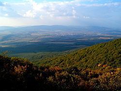
Cserhát ([ˈtʃɛrhaːt]) is a mountain range in Hungary, part of the North Hungarian Mountains, divided between Pest and Nógrád counties. Its highest point is the Naszály with an elevation of 654 metres above sea level.
Map of Buj%C3%A1k, Cserh%C3%A1t, 3047 Hungary
Cserhát stretches from Cserhátalja to the valley of the Ipoly (Slovak: Ipeľ) river. Its central part is mountainous, covered with forests, while its southern and northern parts are hilly.
With regard to architecture, the territory is rich in castles and Hollókő, an ethnographic village is located there.
References
Cserhát Wikipedia(Text) CC BY-SA