
Country Ukraine | ||
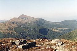 | ||
Nikon d7000 trip to chornohora
Chornohora (literally: Black Mountain, Ukrainian: Чорногора, Polish: Czarnohora, Hungarian: Feketebérc) is the highest mountain range in Western Ukraine in the Eastern Beskids and the Ukrainian Carpathians group, which in turn is part of the Outer Eastern Carpathians.
Contents
- Nikon d7000 trip to chornohora
- Map of Chornohora Ivano Frankivska Ukraine
- Chornohora sky marathon
- Description
- List of peaks
- References
Map of Chornohora, Ivano-Frankivska, Ukraine
Chornohora sky marathon
Description
The range is located on the administrative border between Ivano-Frankivsk and Zakarpattia oblasts. It is adjacent to the Gorgany range. The highest peak of Chornohora is Hoverla (2,062 m) with other high peaks including Pip Ivan (2,022 m) and Petros (2,020 m). The mountains are made of flysch rock.
The major part of the range forms the watershed between the Prut and Tysa River. The lower parts of Chornohora are inhabited by Hutsuls, whose primary occupation is herding. Major tourist centres of Chornohora are Bystrets, Rakhiv, Verkhovyna, Vorokhta and Yasinia.
On August 31, 1939, leading Polish daily Ilustrowany Kurier Codzienny informed about plans of Polish forest authorities, who wanted to create the National Park of Chornohora. Due to the outbreak of World War Two, the park was not established.