
Topo map NTS 031H/11 Elevation 1,907 m | Parent range Eastern Carpathians Mountain type Intrusive | |
 | ||
Similar Ocolașul Mare, Southern Carpathians, Postăvarul Massif, Moldoveanu Peak, Munţii Godeanu | ||
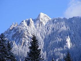
Hiking the carpathians in romania ceahl u massif in neamt county
The Ceahlău Massif ([t͡ʃe̞ahˈləw]) is one of the most notorious mountains of Romania. It is part of the Bistriţa Mountains range of the Eastern Carpathians division, in Neamţ County, in the Moldavia region. The two most important peaks are Toaca (1904 m altitude) and Ocolaşul Mare (1907 m altitude). It is bounded to the east by the Bistriţa River and Lake Bicaz, to the south by the Bicaz River. From the south, the main access point is the village of Izvorul Muntelui, located 12 km north from the town of Bicaz. To the north, Mount Ceahlău is also accessible from Durău.
Contents
- Hiking the carpathians in romania ceahl u massif in neamt county
- Map of CeahlC483u Massif Romania
- Activities
- Hiking
- Skiing
- Camping
- Chalets and refuges
- Notable sights and places
- Other uses of the name
- References
Map of Ceahl%C4%83u Massif, Romania
Activities
Ceahlău National Park shelters a large variety of flora and fauna; some of the species are endemic or rarely seen elsewhere in Romania.
Hiking
Mount Ceahlău is a popular hiking destination in Romania. There are seven main marked trails built for hikers and tourists. There are entering fees for visiting Ceahlău National Park. and fines for non respecting park's regulations. The park is monitored by local rangers and there is also a mountain rescue service (Salvamont).
Skiing
There are ski slopes located at Durău.
Camping
Camping is permitted only in a few designated places: in Durău, near Dochia Chalet and in Izvorul Muntelui.