
Country Canada Town January 1, 1952 Area code Area code 506 | City January 1, 2003 Incorporated village February 8, 1946 Local time Tuesday 7:13 AM | |
 | ||
Weather -11°C, Wind S at 3 km/h, 85% Humidity | ||
Let s take a drive around dieppe new brunswick
Dieppe is a city in the Canadian maritime province of New Brunswick. Statistics Canada counted the population at 25,384 in 2016, making it the fourth largest city in the province.
Contents
- Let s take a drive around dieppe new brunswick
- Map of Dieppe NB Canada
- Holiday inn express hotel suites dieppe airport dieppe new brunswick
- Government
- Geography
- Population
- History
- SylvabreauBattle of the Petitcodiac
- From municipaltowncity designation
- Neighbourhoods
- Provincial public school systems
- CCNB Dieppe
- Parks and recreation
- Festivals
- Sports facilities
- Attractions
- Monuments
- Prominent buildings
- Shopping
- Media
- Greater Moncton International Airport
- Rapid Transit
- Roads and Bridges
- Sister cities
- References
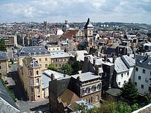
Map of Dieppe, NB, Canada
Dieppe's history and identity goes back to the eighteenth century. It was first incorporated as a town in 1952 and designated as a city in 2003. Its namesake comes from a commune in the Seine-Maritime department, a port on the English Channel, in France and was adopted by the citizens of the area in 1946 to commemorate the Second World War's Operation Jubilee, the Dieppe Raid of 1942.It is officially a francophone city; French is the native language of 73.9% of the population. A majority of the population reports being bilingual, speaking both French and English. Residents generally speak French with a regional accent (colloquially called "Chiac") which is unique to southeastern New Brunswick. A large majority of Dieppe’s population were in favour of the by-law regulating the use of external commercial signs in both official languages, which is a first for the province of New Brunswick. Dieppe is the largest predominantly francophone city in Canada outside Québec; while there are other municipalities with greater total numbers of francophones, they constitute a minority of the population in those cities. Dieppe was one of the co-hosts of the first Congrès Mondial Acadien (Acadian World Congress) which was held in the Moncton region in 1994.
Dieppe is part of the census metropolitan area of Moncton, which is New Brunswick's most populous city at 144,810 according to Statistics Canada in 2016.
Holiday inn express hotel suites dieppe airport dieppe new brunswick
Government
Federal and provincial representatives
Provincial electoral districts Members of the 58th New Brunswick Legislative Assembly (2014), the governing house of the province of New Brunswick.
Federal electoral districts Members of the 42nd Parliament of Canada (2015). A section of southeast Dieppe is in the Beauséjour riding.
Geography
Dieppe is located on the Petitcodiac River. It forms the southeastern part of the Greater Moncton Area, which also includes the city of Moncton, the town of Riverview, Moncton Parish, Memramcook, Coverdale, and Salisbury.
Population
Dieppes' proper population increased significantly from 1971 to 1981 with the 1973 unification of the surrounding communities, i.e. Saint Anselme, Fox Creek/Dover and Chartersville. Being part of Moncton census metropolitan area, Statistics Canada counted the (CMA) population at 144,810 (2016) – making it the largest urban area in New Brunswick and the third largest in Atlantic Canada.
Detailed mother tongue (2011 data)
History
Acadians from the Petitcoudiac and Shepody (french Chipoudy) regions were the first pioneers to settle in the area and founded Sylvabreau in 1730, followed by the Melanson family at Ruisseau-des-Renards (Fox Creek) in 1746 and the LeBlanc and Boudreau families at Chartersville in 1776. Preceding the arrival of Acadian settlers, the southern part of the province was inhabited by the Algonquin people.
Sylvabreau/Battle of the Petitcodiac
The Battle of the Petitcodiac was fought on September 2, 1755 during the British expulsion of the Acadians, after the capture of Fort Beauséjour. The Massachusetts-British force was soundly defeated by troops from Boishébert, Acadian militia, and First Nations' warriors. At the mouth of the Nacadie Creek (Hall's) settlements such as le Coude (The Bend), Sylvabreau and the surrounding hamlets were destroyed. Even after these raids, Acadians returned to these villages and the numbers grew as the deportation from peninsular Nova Scotia continued, followed by the deportation from present-day Prince Edward Island and Cape Breton. Victory for the British occurred three years later (1758) during the Petitcodiac River Campaign (fr:La bataille du Cran) which resulted in the deportation of the Acadians that lived along the Petitcodiac River or had taken refuge there from earlier deportation operations.
From municipal/town/city designation
Dieppe was known as Upper Village after the Expulsion and was settled by the Surette, Maillet, and Thibodeau families, while Chartersville was called Leblanc's Village and also included members of the Boudreau's clan. Prior to 1800, Pierre Bourgeois had established himself on the (Ruisseau des Renards) Fox Creek salt marsh. Agriculture, forestry and some fishing sustained these Acadian families up until the mid-1800s, when shipbuilding and railways created employment opportunities for Acadians around the Moncton area. After a bridge was completed in 1867 at the mouth of Hall's Creek (Nacadie during the French settlement at Le Coude), a road was constructed that link the incorporated Town of Moncton's Westmorland Road (Main Street) to the (French Village) Dieppe area. This road went through farmland that had belong to the Leger family and intersected the old road (Acadie Avenue) that had taken travellers up and around Hall's Creek to the community of Lewisville to get to Moncton. By 1900, the little area around the intersection became known as Léger's Corner, and with the increasing traffic from the bridge, merchants became attracted to the corner and soon set up shops and services around the intersection. Prior to the First World War, a small residential development was erected, and the community continue to grow until the Second World War. Then a population explosion occurred. Léger's Corner received the largest influx of military personnel in southeastern New Brunswick. Ten thousand airmen (due to the airport) and their support staff arrived overnight in 1940, and soon temporary warehouses and housing were erected. When Léger's Corner became incorporated as a municipal village in 1946, the community was renamed Dieppe, after a port in France on the English Channel, to honour the 913 Canadian servicemen who took part in the Dieppe Raid, the bloody landing by Allied soldiers, on August 19, 1942, during the Second World War. Then, part of Lakeburn was annexed in 1946 and Dieppe-East in 1948. A referendum (262 for, 232 against) marginally favoured the village to incorporate as the Town of Dieppe in 1952. At that time, Dieppe had over 3,000 inhabitants within its boundaries. Growth continued unabated throughout the 1950s and 1960s as Dieppe annexed the villages of Saint-Anselme and Chartersville and the local service districts of Fox Creek-Dover(Upper Dover), the latter in 1973. With its rural expansion came a growth in population exceeding 8,500 in the 1981 census. Within the 1980s and early 1990s, the Town of Dieppe, like the rest of the region, went through an economic downfall which limited its growth in population. By 2001, the Greater Moncton area and Dieppe's economy flourished and with it came a population increment of nearly 15,000 in 2001 to over 23,000 in 2011. To preserve its heritage, culture and identity as a community in Southern New Brunswick, Dieppe opted to incorporate itself as a city on January 1, 2003. At that time it became New Brunswick's eighth incorporated city.
Maps of Dieppe from the 1960s shows Champlain Street below Acadie Avenue as Main Street and above the intersection as Airport Road.
Neighbourhoods
Dieppe's geographic area is a direct union of Acadian parishes and villages such as:
Provincial public school systems
The following are a list of public schools in the city:
CCNB - Dieppe
Parks and recreation
As of 2011, the community has some thirty parks and green spaces: one city park, fifteen district parks, seven neighbourhood parks, five green islands and a linear park with 20 km (12 mi) of trails.
Festivals
Sports facilities
Attractions
The city of Dieppe is a participant in the province of New Brunswick's local historic places program, funded by the government of Canada through the historic places initiative.
Monuments
Prominent buildings
Shopping
Media
Greater Moncton International Airport
The Greater Moncton International Airport was officially opened in 2002 by Queen Elizabeth II. It is 6 km from downtown Dieppe and 10 km from Moncton. Moncton Flight College, the largest private flight school in Canada, is at the airport. MFC has trained over 16,000 pilots from around the world since 1929.
Rapid Transit
Codiac Transpo is the city of Moncton, Dieppe and town of Riverview's public transit system. Within Codiac transpo 47 bus fleet, three services Dieppe's main arteries and subdivisions seven days a week; in addition to its numerous fleet of Codiac Buses at the Champlain Place terminal. Services to the inner city has been offered since 1984. Services is provided seven days a week with late evening routes and modified weekend hours. In 2012, the route scheduling was modified to reflect the Codiac Transpo services. With it came a change transit destination and new route numbers.
Roads and Bridges
(The present site of the Fox Creek bridge holds historical facts which dates back to the 1800s. A geographical map of the region made by the English forces shows families with the Amirault surnames living in the area. Later, Acadians built earthen dykes (aboiteau) at Pointe des renards to prevent flooding, which also served as "bridges" for both banks of the river. In 1924, a low rise bridge was constructed that flooded every two to three years.)
Both bridges are on Route 106, which follows the original provincial Route 2 from Quebec to Nova Scotia. Through the late 1950s and 1960s, a number of bypasses and realignments, mostly two-lane, were built to improve Route 2 with federal Trans-Canada Highway funds. The first, built in the 1950s, was around Moncton. The old road became Route 2A, but it was renumbered Route 6 in 1965 and 106 in 1984 during a reclassification of provincial highways. It is still signed as Route 6 at the corner of Cameron St. and Main St. (the current Route 106) in downtown Moncton - At Moncton, Route 106 runs through Main Street and passes Hall's Creek bridge up to the intersection in centre-ville Dieppe connecting Amirault Street, which leaves the city to the southeast en route to Memramcook. The aforementioned route had a significant impact for the future community of Dieppe has it linked southeast New Brunswick to Nova Scotia prior to the completion of the new Trans-Canada Highway. In addition, it attracted new residents to cultivate the land and build dwellings throughout the 19th and 20th centuries.