
Highest elevation 535 m (1,755 ft) Demonym Cape Bretoner Province Nova Scotia | Area rank 77th Area 10,311 km² Peak White Hill | |
 | ||
Points of interest Alexander Graham Bell Natio, Highland Village Museum, Skyline Trail, The Cabot Trail, Kennington Cove Road | ||
Top reasons to live in cape breton island
Cape Breton Island (French: île du Cap-Breton—formerly Île Royale; Scottish Gaelic: Ceap Breatainn or Eilean Cheap Bhreatainn; Míkmaq: Únamakika; or simply Cape Breton) is an island on the Atlantic coast of North America and part of the province of Nova Scotia, Canada. Its name may derive from Capbreton near Bayonne, or more probably from the word Breton, the French adjective form of the proper noun Bretagne, the French historical region.
Contents
- Top reasons to live in cape breton island
- Map of Cape Breton Island Nova Scotia Canada
- Where to stay on the cabot trail cape breton island nova scotia
- History
- le Royale
- Colony of Cape Breton
- Merger with Nova Scotia
- 20th century
- Geography
- Demographics
- Economy
- Traditional music
- Film and television
- Notable people
- References
Map of Cape Breton Island, Nova Scotia, Canada
The 10,311 km2 (3,981 sq mi) island accounts for 18.7% of the Nova Scotia's total area. Although physically separated from the Nova Scotia peninsula by the Strait of Canso, the 1,385 m (4,544 ft) long rock-fill Canso Causeway connects it to mainland Nova Scotia. The island is east-northeast of the mainland with its northern and western coasts fronting on the Gulf of Saint Lawrence; its western coast also forms the eastern limits of the Northumberland Strait. The eastern and southern coasts front the Atlantic Ocean; its eastern coast also forms the western limits of the Cabot Strait. Its landmass slopes upward from south to north, culminating in the highlands of its northern cape. One of the world's larger salt water lakes, Bras d'Or ("Arm of Gold" in French), dominates the island's centre.
The island is divided into four of Nova Scotia's eighteen counties: Cape Breton, Inverness, Richmond, and Victoria. Their total population at the 2016 census numbered 132,010 "Cape Bretoners"; this is approximately 15% of the provincial population. Cape Breton Island has experienced a decline in population of approximately 2.9 since the 2011 census. Approximately 75% of the island's population is in the Cape Breton Regional Municipality (CBRM) which includes all of Cape Breton County and is often referred to as Industrial Cape Breton, given the history of coal mining and steel manufacturing in this area, which was Nova Scotia's industrial heartland throughout the 20th century.
The island has five reserves of the Mi'kmaq Nation: Eskasoni, Membertou, Wagmatcook, Waycobah, and Potlotek/Chapel Island. Eskasoni is the largest in both population and land area.
Where to stay on the cabot trail cape breton island nova scotia
History
Cape Breton Island's first residents were likely Archaic maritime natives, ancestors of the Mi'kmaq, the people who were inhabiting the island at the time of European arrival. John Cabot reportedly visited the island in 1497. However, historians are unclear as to whether Cabot first visited Newfoundland or Cape Breton Island. This discovery is commemorated by Cape Breton's Cabot established a fishing colony on the island. As many as two hundred settlers lived in a village, the name of which is not known, located according to some historians at what is now present day Ingonish on the island's northeastern peninsula. This Portuguese colony's fate is unknown, but it is mentioned as late as 1570.
During the Anglo-French War of 1627 to 1629, under Charles I, by 1629 the Kirkes took Quebec City; Sir James Stewart of Killeith, Lord Ochiltree planted a colony on Cape Breton Island at Baleine, Nova Scotia; and Alexander’s son, William Alexander, 1st Earl of Stirling, established the first incarnation of "New Scotland" at Port Royal. These Scottish triumphs, which left Cape Sable as the only major French holding in North America, did not last. Charles I’s haste to make peace with France on the terms most beneficial to him meant the new North American gains would be bargained away in the Treaty of Saint-Germain-en-Laye (1632).
The French quickly defeated the Scots at Baleine, and established the first permanent settlements on Île Royale: present day Englishtown (1629) and St. Peter's (1630). These settlements lasted almost continuously until Nicolas Denys left in 1659. Île Royale was vacant for more than fifty years until the communities along with Louisbourg were established in 1713.
Île Royale
Known as "Île Royale" ("Royal Island") to the French, the island also saw active settlement by France. After the French ceded their colonies on Newfoundland and the Acadian mainland to the British by the Treaty of Utrecht in 1713, the French relocated the population of Plaisance, Newfoundland, to Île Royale and the French garrison was established in the central eastern part at Sainte Anne. As the harbour at Sainte Anne experienced icing problems, it was decided to build a much larger fortification at Louisbourg to improve defences at the entrance to the Gulf of Saint Lawrence and to defend France's fishing fleet on the Grand Banks. The French also built the Louisbourg Lighthouse in 1734, the first lighthouse in Canada and one of the first in North America. In addition to Cape Breton Island, the French colony of Île Royale also included Île Saint-Jean, today called Prince Edward Island.
Louisbourg itself was one of the most important commercial and military centres in New France. Louisbourg was captured by New Englanders with British naval assistance in 1745 and by British forces in 1758. The French population of Île Royale was deported to France after each siege. While French settlers returned to their homes in Île Royale after the Treaty of Aix-la-Chapelle was signed in 1748, the fortress was demolished after the second siege. Île Royale remained formally part of New France until it was ceded to Great Britain by the Treaty of Paris in 1763. It was then merged with the adjacent, British colony of Nova Scotia (present day peninsular Nova Scotia and New Brunswick). Acadians who had been expelled from Nova Scotia and Île Royale were permitted to settle in Cape Breton beginning in 1764, and established communities in north-western Cape Breton, near Cheticamp, and southern Cape Breton, on and near Isle Madame.
Some of the first British-sanctioned settlers on the island following the Seven Years' War were Irish, although upon settlement they merged with local French communities to form a culture rich in music and tradition. From 1763 to 1784, the island was administratively part of the colony of Nova Scotia and was governed from Halifax.
The first permanently settled Scottish community on Cape Breton Island was Judique, settled in 1775 by Michael Mor MacDonald. He spent his first winter using his upside-down boat for shelter, which is reflected in the architecture of the village's Community Centre. He composed a song about the area called "O 's àlainn an t-àite", or "O, Fair is the Place."
Colony of Cape Breton
In 1784, Britain split the colony of Nova Scotia into three separate colonies: New Brunswick, Cape Breton Island, and present-day peninsular Nova Scotia, in addition to the adjacent colonies of St. John's Island (renamed Prince Edward Island in 1798) and Newfoundland. The colony of Cape Breton Island had its capital at Sydney on its namesake harbour fronting on Spanish Bay and the Cabot Strait. Its first Lieutenant-Governor was Joseph Frederick Wallet DesBarres (1784–1787) and his successor was William Macarmick (1787).
A number of United Empire Loyalists emigrated to the Canadian colonies, including Cape Breton. David Mathews, the former Mayor of New York City during the American Revolution, emigrated with his family to Cape Breton in 1783. He succeeded Macarmick as head of the colony and served from 1795 to 1798.
From 1799 to 1807, the military commandant was John Despard, brother of Edward.
An order forbidding the granting of land in Cape Breton, issued in 1763, was removed in 1784. The mineral rights to the island were given over to the Duke of York by an order-in-council. The British government had intended that the Crown take over the operation of the mines when Cape Breton was made a colony, but this was never done, probably because of the rehabilitation cost of the mines. The mines were in a neglected state, caused by careless operations dating back at least to the time of the final fall of Louisbourg.
Large-scale shipbuilding began in the 1790s, beginning with schooners for local trade moving in the 1820s to larger brigs and brigantines, mostly built for British shipowners. Shipbuilding peaked in the 1850s, marked in 1851 by the full rigged ship Lord Clarendon, the largest wooden ship ever built in Cape Breton.
Merger with Nova Scotia
In 1820, the colony of Cape Breton Island was merged for the second time with Nova Scotia. This development is one of the factors which led to large-scale industrial development in the Sydney Coal Field of eastern Cape Breton County. By the late 19th century, as a result of the faster shipping, expanding fishery and industrialization of the island, exchanges of people between the island of Newfoundland and Cape Breton increased, beginning a cultural exchange that continues to this day.
During the first half of the 19th century, Cape Breton Island experienced an influx of Highland Scots numbering approximately 50,000 as a result of the Highland Clearances. Today, the descendants of the Highland Scots dominate Cape Breton Island's culture, particularly in rural communities. To this day, Gaelic is still the first language of a number of elderly Cape Bretoners. The growing influence of English-dominated media from outside the Scottish communities saw the use of this language erode quickly during the 20th century. Many of the Scots who immigrated there were either Roman Catholics or Presbyterians, which can be seen in a number of island landmarks and place names.
The 1920s were some of the most violent times in Cape Breton. They were marked by several severe labour disputes. The famous murder of William Davis by strike breakers, and the seizing of the New Waterford power plant by striking miners led to a major union sentiment that persists to this day in some circles. William Davis Miners' Memorial Day is celebrated in coal mining towns to commemorate the deaths of miners at the hands of the coal companies.
20th century
The turn of the 20th century saw Cape Breton Island at the forefront of scientific achievement with the now-famous activities launched by inventors Alexander Graham Bell and Guglielmo Marconi.
Following his successful invention of the telephone and being relatively wealthy, Bell acquired land near Baddeck in 1885, largely due to surroundings reminiscent of his early years in Scotland. He established a summer estate complete with research laboratories, working with deaf people—including Helen Keller—and continued to invent. Baddeck would be the site of his experiments with hydrofoil technologies as well as the Aerial Experiment Association, financed by his wife, which saw the first powered flight in the British Empire when the AEA Silver Dart took off from the ice-covered waters of Bras d'Or Lake. Bell also built the forerunner to the iron lung and experimented with breeding sheep.
Marconi's contributions to Cape Breton Island were also quite significant, as he used the island's geography to his advantage in transmitting the first North American trans-Atlantic radio message from a station constructed at Table Head in Glace Bay to a receiving station at Poldhu in Cornwall, England. Marconi's pioneering work in Cape Breton marked the beginning of modern radio technology. Marconi's station at Marconi Towers, on the outskirts of Glace Bay, became the chief communication centre for the Royal Canadian Navy in World War I through to the early years of World War II.
During World War II, there was a significant drop of Gaelic speakers due to a prejudice caused by Ireland's neutrality during the war.
Promotions for tourism beginning in the 1950s recognized the importance of the Scottish culture to the province, and the provincial government started encouraging the use of Gaelic once again. The establishment of funding for the Gaelic College of Celtic Arts and Crafts and formal Gaelic language courses in public schools are intended to address the near-loss of this culture to English assimilation.
In the 1960s, the Fortress of Louisbourg was partially reconstructed by Parks Canada. Since 2009, this National Historic Site of Canada has attracted an average of 90 000 visitors per year.
In early 2016, Cape Breton humorously announce any American 'refugees' fleeing the nation if Donald Trump (and possibly Hillary Clinton) wins the presidential election would be welcomed to Cape Breton, with the only requirement being a Canadian citizenship. In their website's FAQ, they have state they are doing this both to help American 'refugees' and because "...our population is shrinking. A slow economy, in combination with out-migration has us on an unsustainable path. The truth is we welcome all, no matter the ideology. We have a beautiful island, a friendly people, a rich culture and a bright future...". As of November 9, 2016, the day following Election Day, as well as Trump's victory, the offer still stands.
Geography
The island measures 10,311 square kilometres (3,981 sq mi) in area, making it the 77th largest island in the world and Canada's 18th largest island. Cape Breton Island is composed mainly of rocky shores, rolling farmland, glacial valleys, barren headlands, mountains, woods and plateaus. Geological evidence suggests at least part of the island was joined with present-day Scotland and Norway, now separated by millions of years of continental drift.
Cape Breton Island's northern portion is dominated by the Cape Breton Highlands, commonly shortened to simply the "Highlands", which are an extension of the Appalachian mountain chain. The Highlands comprise the northern portions of Inverness and Victoria counties. In 1936, the federal government established the Cape Breton Highlands National Park covering 949 km2 (366 sq mi) across the northern third of the Highlands. The Cabot Trail scenic highway also encircles the palteau's coastal perimeter.
Cape Breton Island's hydrological features include the Bras d'Or Lake system, a salt-water fjord at the heart of the island, and freshwater features including Lake Ainslie, the Margaree River system, and the Mira River. Innumerable smaller rivers and streams drain into the Bras d'Or Lake estuary and on to the Gulf of St. Lawrence and Atlantic coasts.
Cape Breton Island is joined to the mainland by the Canso Causeway, which was completed in 1955, enabling direct road and rail traffic to and from the island, but requiring marine traffic to pass through the Canso Canal at the eastern end of the causeway.
Cape Breton Island is divided into four counties: Cape Breton, Inverness, Richmond, and Victoria.
The climate is one of mild, often pleasantly warm summers and cold winters, although the proximity to the Atlantic Ocean and Gulf Stream moderates the extreme winter cold found on the mainland, especially on the east side that faces the Atlantic. Precipitation is abundant year round, with annual totals up to 60 inches on the eastern side facing the Atlantic storms. Considerable snowfall occurs in winter, especially in the highlands.
Demographics
The island's residents can be grouped into five main cultures; Scottish, Mi'kmaq, Acadian, Irish, and English, with respective languages Scottish Gaelic, Mi'kmaq, French, and English. English is now the primary language, including a locally distinctive Cape Breton accent, while Mi'kmaq, Scottish Gaelic and Acadian French are still spoken in some communities.
Later migrations of Black Loyalists, Italians, and Eastern Europeans mostly settled in the island's eastern part around the industrial Cape Breton region. Cape Breton Island's population has been in decline for almost two decades with an increasing exodus in recent years due to economic conditions.
According to the Census of Canada, the population of Cape Breton Island in 2011 was 135,974, a 4.4% decline from 142,298 in 2006, and a 14.1% decline from 158,260 in 1996.
Religious groups
Statistics Canada in 2001 reported a "religion" total of 145,525 for Cape Breton, including 5,245 with "no religious affiliation." Major categories included:
A synagogue in Sydney serves a small historic Jewish community which was once one of the largest in eastern Canada with four shuls: one in Glace Bay, one in New Waterford, one in Whitney Pier, and the one in Sydney. More recent Muslim immigrants hold Friday prayers at Cape Breton University and the former Holy Redeemer Hall in Whitney Pier. Buddhists are a small minority (105 in 2001, according to Statistics Canada), although Gampo Abbey in Pleasant Bay has been operational since 1984.
Economy
Much of the recent economic history of Cape Breton Island can be tied to the coal industry.
The island has two major coal deposits:
Sydney has traditionally been the main port, with facilities in a large, sheltered, natural harbour. It is the island's largest commercial centre and home to the Cape Breton Post daily newspaper, as well as one television station, CJCB-TV (CTV), and several radio stations. The Marine Atlantic terminal at North Sydney is the terminal for large ferries traveling to Channel-Port aux Basques and seasonally to Argentia, both on the island of Newfoundland.
Point Edward on the west side of Sydney Harbour is the location of Sydport, a former navy base (HMCS Protector) now converted to commercial use. The Canadian Coast Guard College is nearby at Westmount. Petroleum, bulk coal, and cruise ship facilities are also in Sydney Harbour.
Glace Bay, the second largest urban community in population, was the island's main coal mining centre until its last mine closed in the 1980s. Glace Bay was the hub of the Sydney & Louisburg Railway and a major fishing port. At one time, Glace Bay was known as the largest town in Nova Scotia, based on population.
Port Hawkesbury has risen to prominence since the completion of the Canso Causeway and Canso Canal created an artificial deep-water port, allowing extensive petrochemical, pulp and paper, and gypsum handling facilities to be established. The Strait of Canso is completely navigable to Seawaymax vessels, and Port Hawkesbury is open to the deepest-draught vessels on the world's oceans. Large marine vessels may also enter Bras d'Or Lake through the Great Bras d'Or channel, and small craft can use the Little Bras d'Or channel or St. Peters Canal. While commercial shipping no longer uses the St. Peters Canal, it remains an important waterway for recreational vessels.
The industrial Cape Breton area faced several challenges with the closure of the Cape Breton Development Corporation's (DEVCO) coal mines and the Sydney Steel Corporation's (SYSCO) steel mill. In recent years, the Island's residents have tried to diversify the area economy by investing in tourism developments, call centres, and small businesses, as well as manufacturing ventures in fields such as auto parts, pharmaceuticals, and window glazings.
While the Cape Breton Regional Municipality is in transition from an industrial to a service-based economy, the rest of Cape Breton Island outside the industrial area surrounding Sydney-Glace Bay has been more stable, with a mixture of fishing, forestry, small-scale agriculture, and tourism.
Tourism in particular has grown throughout the post-Second World War era, especially the growth in vehicle-based touring, which was furthered by the creation of the Cabot Trail scenic drive. The scenery of the island is rivalled in northeastern North America by only Newfoundland; and Cape Breton Island tourism marketing places a heavy emphasis on its Scottish Gaelic heritage through events such as the Celtic Colours Festival, held each October, as well as promotions through the Gaelic College of Celtic Arts and Crafts.
Whale-watching is a popular attraction for tourists. Whale-watching cruises are operated by vendors from Baddeck to Cheticamp. The most popular species of whale found in Cape Breton's waters is the Pilot whale.
The island's primary east-west road is Highway 105, the Trans-Canada Highway, although Trunk 4 is also heavily used. Highway 125 is an important arterial route around Sydney Harbour in the Cape Breton Regional Municipality. The Cabot Trail, circling the Cape Breton Highlands, and Trunk 19, along the island's western coast, are important secondary roads. The Cape Breton and Central Nova Scotia Railway maintains railway connections between the port of Sydney to the Canadian National Railway in Truro
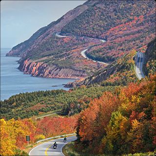
The Cabot Trail is a scenic road circuit around and over the Cape Breton Highlands with spectacular coastal vistas; over 400,000 visitors drive the Cabot Trail each summer and fall. Coupled with the Fortress of Louisbourg, it has driven the growth of the tourism industry on the island in recent decades. The Condé Nast travel guide has rated Cape Breton Island as one of the world's best island destinations.
Traditional music
Cape Breton is well known for its traditional fiddle music, which was brought to North America by Scottish immigrants during the Highland Clearances. The traditional style has been well preserved in Cape Breton, and céilidhs have become a popular attraction for tourists. Inverness County in particular has a heavy concentration of musical activity, with regular performances in communities such as Mabou and Judique. Judique is recognized as 'Baile nam Fonn', (literally: Village of Tunes) or the 'Home of Celtic Music', featuring the Celtic Music Interpretive Centre. Performers who have received significant recognition outside of Cape Breton include Bruce Guthro, Buddy MacMaster, Natalie MacMaster, Ashley MacIsaac, The Rankin Family, Aselin Debison, Gordie Sampson, Lee Cremo, and the Barra MacNeils.
The Men of the Deeps are a male choral group of current and former miners from the industrial Cape Breton area.
Film and television
Notable people
Cape Breton artists who have been recognized with major national or international awards include actor Harold Russell of North Sydney, who won an Academy Award in 1946 for his portrayal of Homer Parrish in The Best Years of Our Lives, and Lynn Coady and Linden MacIntyre of Inverness County, who are both past winners of the Giller Prize for Canadian literature. The Rankin Family and Rita MacNeil have recorded multiple albums certified as Double Platinum by Music Canada.
People from Cape Breton have also achieved a number of firsts in Canadian politics and governance. These include Mayann Francis of Whitney Pier, the first Black Lieutenant Governor of Nova Scotia, and Elizabeth May of Margaree Harbour, the first member of the Green Party of Canada elected to the Canadian House of Commons.
Cape Breton Island is also home to YouTube weather sensation Frankie MacDonald. Frankie MacDonald on his YouTube channel "dogsandwolves" has over 100,000 subscribers. He accurately predicted an above Magnitude 7 earthquake in New Zealand in November 2016.
Director Ashley McKenzie's 2016 film Werewolf is set on the island and features local actors; McKenzie grew up on the island.