
Names Triana SATCAT no. 40390 | Mission type Solar observation COSPAR ID 2015-007A | |
 | ||
Website www.nesdis.noaa.gov/DSCOVR/ | ||
Deep space climate observatory satellite update
Deep Space Climate Observatory (DSCOVR; formerly known as Triana, unofficially known as GoreSat) is a NOAA Earth observation and space weather satellite launched by SpaceX on a Falcon 9 launch vehicle on February 11, 2015 from Cape Canaveral.
Contents
- Deep space climate observatory satellite update
- History
- Spacecraft
- PlasMag
- EPIC
- NISTAR
- Launch
- Post launch flight test
- Operation
- References

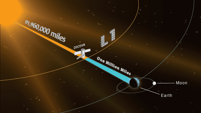
It was originally developed as a NASA satellite proposed in 1998 by then-Vice President Al Gore for the purpose of Earth observation. It is in a Lissajous orbit at the Sun-Earth L1 Lagrangian point, 1,500,000 km (930,000 mi) from Earth, to monitor variable solar wind condition, provide early warning of approaching coronal mass ejections and observe phenomena on Earth including changes in ozone, aerosols, dust and volcanic ash, cloud height, vegetation cover and climate. At this location it has a continuous view of the Sun and the sunlit side of the Earth. The satellite is orbiting the Sun-Earth L1 point in a six-month period, with a spacecraft-Earth-Sun angle varying from 4 to 15 degrees. It takes full-Earth pictures about every two hours and is able to process them faster than other Earth observation satellites.

DSCOVR started orbiting around L1 by June 8, 2015, just over 100 days after launch. After the spacecraft arrived on site and entered its operational phase, NASA began releasing near-real time images of Earth through the EPIC instrument's website.
History

Originally known as Triana, named after Rodrigo de Triana, the first of Columbus's crew to sight land in the Americas, the satellite's original purpose was to provide a near-continuous view of the entire Earth and make that live image available via the Internet. Gore hoped not only to advance science with these images, but also to raise awareness of the Earth itself, updating the influential Blue Marble photograph taken by Apollo 17. In addition to an imaging camera, a radiometer would take the first direct measurements of how much sunlight is reflected and emitted from the whole Earth (albedo). This data could constitute a barometer for the process of global warming. The scientific goals expanded to measure the amount of solar energy reaching Earth, cloud patterns, weather systems, monitor the health of Earth's vegetation, and track the amount of UV light reaching the surface through the ozone layer.

In 1999, NASA's Inspector General reported that "the basic concept of the Triana mission was not peer reviewed", and "Triana's added science may not represent the best expenditure of NASA's limited science funding." The Bush Administration put the project on hold shortly after George W. Bush's inauguration. Members of the U.S. Congress asked the National Academy of Sciences whether the project was worthwhile. The resulting report, released March 2000, stated that the mission was "strong and scientifically vital."

Triana was removed from its original launch opportunity on STS-107 (the ill-fated Columbia mission in 2003). The $100 million satellite remained in storage for the duration of the Bush administration. In November 2008 the satellite was removed from storage and began recertification for a possible launch on board a Delta II or a Falcon 9. Al Gore used part of his book Our Choice (2009) as an attempt to revive debate on the DSCOVR payload. The book mentions legislative efforts by Senators Barbara Mikulski and Bill Nelson to get the satellite launched. NASA renamed the satellite Deep Space Climate Observatory (DSCOVR), in an attempt to regain support for the project. In February 2011, the Obama administration attempted to secure funding to re-purpose the DSCOVR spacecraft as a solar observatory to replace the aging Advanced Composition Explorer (ACE) spacecraft.

In September 2013 NASA cleared DSCOVR to proceed to the implementation phase targeting an early 2015 launch, which had been announced in December 2012 as launching on a SpaceX Falcon 9 rocket. NASA Goddard Space Flight Center is providing management and systems engineering to the mission.
Spacecraft
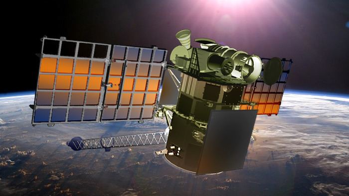
DSCOVR is built on the SMEX-Lite spacecraft bus, and has a launch mass of approximately 570 kg (1,257 lb). The main science instrument sets are the Sun-observing Plasma Magnetometer (PlasMag) and the Earth-observing NIST Advanced Radiometer (NISTAR) and Earth Polychromatic Imaging Camera (EPIC). DSCOVR has two deployable solar arrays, a propulsion module, boom, and antenna.
PlasMag
The Plasma-Magnetometer (PlasMag) measures solar wind for space weather predictions. It has three instruments:
EPIC
The Earth Polychromatic Imaging Camera (EPIC) takes images of the sunlit side of Earth for various Earth sciences purposes, in 10 different channels from ultraviolet to near infrared. Ozone and aerosol levels will be monitored, as well as cloud dynamics, properties of the land and vegetations.
EPIC has an aperture diameter of 30.5 cm (12.0 in), f 9.38, a FOV of 0.61° and an angular sampling resolution of 1.07 arcsec. Earth apparent diameter will vary from 0.45° to 0.53° full width. Exposure time for each of the 10 narrowband channels (317, 325, 340, 388, 443, 552, 680, 688, 764 and 779 nm) is about 40 ms, and the camera will produce 2048×2048 pixel images, but to increase number of downloadable images to 10 per hour the resolution will be averaged to 1024×1024 on board. The final resolution will be 25 km/pixel (16 mi/pixel).
NISTAR
National Institute of Standards and Technology Advanced Radiometer (NISTAR) measures irradiance of the sunlit face of the Earth. This data is to be used to study changes in Earth's radiation budget caused by natural and human activities. The radiometer measures in four channels:
Launch
The launch provider SpaceX successfully launched DSCOVR on February 11, 2015, following two scrubbed launches.
Post-launch flight test
SpaceX planned to conduct a test flight where they would attempt to bring the first stage back through the atmosphere and land the expended first stage on a 90-by-50-meter (300 ft × 160 ft) floating landing platform. Relative to earlier tests, the first stage return on DSCOVR was much more challenging, especially in atmospheric reentry due to the deep space nature of the Earth-Sun L1 launch trajectory for DSCOVR. SpaceX expected deceleration-force loads to be twice as high and rocket heating to quadruple over the reentry conditions on Falcon 9 Flight 14. Before the launch, the drone ship was in ocean surface conditions that made the barge landing infeasible. Therefore, the landing platform attempt was called off and the first stage made an over-water soft landing instead. This continued the collection of returnable first stage test data on all the earlier phases of the flight test, and added data on stage survival following a high-speed, high-load atmospheric entry.
Operation
On July 6, 2015, DSCOVR returned its first view of the entire sunlit side of Earth from approximately one million miles (1,600,000 km) away, taken by the EPIC instrument. EPIC will provide a daily series of Earth images enabling the first time study of daily variations over the entire globe. The images, available 12 to 36 hours after they are made, will be posted to a dedicated web page by September 2015.
DSCOVR was placed in operation at the L1 Lagrangian point to monitor the sun, because the constant stream of particles from the sun (the solar wind) reaches L1 about 60 minutes before reaching Earth. DSCOVR will usually be able to provide a 15 to 60 minute warning before a surge of particles and magnetic field, from a coronal mass ejection (CME) reaches Earth, and creates a geomagnetic storm. DSCOVR data will also be used to improve predictions of the impact locations of a geomagnetic storm to be able to take preventative action. Electronic technologies such as satellites in geosynchronous orbit are at risk of unplanned disruptions without warnings from DSCOVR and other monitoring satellites at L1.
On July 16–17, 2015, DSCOVR took a series of images showing the Moon engaged in a transit of Earth. The images were taken between 19:50 and 00:45 UTC. The animation was composed of monochrome images taken in different color filters at 30 second intervals for each frame, resulting in a slight color fringing for the Moon in each finished frame. Due to its position at Sun-Earth L1, DSCOVR will always see the Moon illuminated, and will always see its far side when it passes in front of Earth.
On October 19, 2015, NASA opened a new website to host near-live 'Blue Marble' images taken by EPIC of Earth. At least twelve images are released each day at regular intervals, showcasing the Earth as it rotates on its axis. The resolution of the images will range from 6.2 to 9.4 miles per pixel (10 to 15 km/pixel), and the short exposure times will render points of starlight invisible.