
Formed December 20, 1997 Damage > $100,000 (1998 USD) | Dissipated January 10, 1998 Fatalities 1 | |
 | ||
Highest winds 10-minute sustained: 230 km/h (145 mph)1-minute sustained: 260 km/h (160 mph) Lowest pressure 900 hPa (mbar); 26.58 inHg Date 20 December 1997 – 10 January 1998 Similar Cyclone Ron, Cyclone Sose, Cyclone Tia, Cyclone Trina, Cyclone Esau | ||
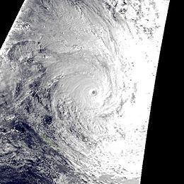
Severe Tropical Cyclone Susan was one of the most intense tropical cyclones on record within the South Pacific basin, which was first noted on December 20, 1997, as a weak tropical disturbance located to the north of American Samoa. Over the next 12 days, the disturbance remained weak while it gradually moved towards the southwest before it started to rapidly develop on January 2, 1998 while it was located near the Fijian dependency of Rotuma. The disturbance was declared a tropical cyclone later that day, but was not named Susan until the next day, after it had intensified into a category 2 tropical cyclone on the Australian Scale. Over the next few days, Susan moved towards the southwest and continued to intensify before it reached its peak intensity as a category five tropical cyclone during January 5 while it was located about 400 km (250 mi) to the northwest of Vanuatu's capital city Port Vila.
Contents
At this stage as the cyclone was moving towards the southwest it posed a severe threat to Vanuatu however, during that day Susan recurved towards the southeast and subsequently spared Vanuatu a direct hit. After sparing Vanuatu a direct hit, Susan started to accelerate towards the southeast and while starting to weaken significantly passed close enough to Fiji during January 7 and 8 to cause gale force winds in Fiji's southern and western islands. While continuing to move towards the southeast, Susan started to interact with Severe Tropical Cyclone Ron during January 8 before it absorbed Ron by 0600 UTC the next day and starting to transition into an extratropical cyclone. The extratropical remnants of the combined systems were then monitored for another day until they were last noted on January 10, bringing an unseasonable cold snap to New Zealand. Despite sparing Vanuatu and Fiji direct hits, heavy rain and gale force winds associated with Susan were reported to have caused minor damage to several Vanuatuan and Fijian islands. These islands included Viti Levu where a possible tornado destroyed the roof of a shopping centre and the Vanuatuan island of Ambrym, where a woman died after being hit by a falling coconut tree, while gathering supplies to secure her house with.
Meteorological history
On December 20, 1997, the Fiji Meteorological Service's Regional Specialized Meteorological Center in Nadi, Fiji (RSMC Nadi), started to monitor a weak tropical disturbance that was located about 915 km (570 mi), to the northwest of Pago-Pago in American Samoa. Over the next two weeks the system gradually moved towards the west-southwest, without developing into a tropical cyclone. During January 2, a mid-level ridge of high pressure developed between Fiji and Vanuatu, which provided an area of low vertical wind shear. The system subsequently started to show signs of significant development, before early on January 3, the United States Joint Typhoon Warning Center (JTWC) initiated warnings on the system and designated it as Tropical Cyclone 11P. RSMC Nadi subsequently reported later that day that the depression had intensified into a category 1 tropical cyclone, on the Australian tropical cyclone intensity scale, while located near the Fiji dependency of Rotuma. During that day the system continued to rapidly develop with RSMC Nadi reporting early on January 4, that Susan had become a category 3 severe tropical cyclone, with 10-minute sustained windspeeds of 120 km/h (75 mph). During January 4, Susan continued to rapidly intensify with the JTWC reporting that Susan had become equivalent to a category 1 hurricane on the Saffir-Simpson Hurricane Scale as convection surrounding the system organized further and developed an eye feature.
As the ridge of high pressure that was located to the south of the cyclone started to weaken, which meant that Susan started to move further towards the southwest. RSMC Nadi then reported at 0000 UTC on January 5, that the system had become a category 5 severe tropical cyclone with 10-minute sustained wind speeds of 140 mph (220 km/h), before reporting 6 hours later that Susan had reached its peak 10-minute sustained wind speeds of 145 mph (225 km/h) and a peak pressure of 900 hPa (26.58 inHg). Around this time RSMC Nadi reported that the system might of developed a double eye feature while the JTWC reported that Susan had peaked with 1-minute wind speeds of 260 km/h (160 mph) equivalent to a weak category five hurricane on the SSHS. As the system reached its peak intensity, Susan was moving towards the southwest and as a result, it "posed a severe threat to Vanuatu," however during that afternoon, Susan recurved towards the southeast "just in time to spare Vanuatu, a direct hit.” After turning away from Vanuatu, Susan accelerated towards the southeast while remaining near or at its peak intensities, before starting to weaken significantly during January 7. RSMC Nadi then reported early the next day, that Susan had weakened into a category 4 severe tropical cyclone while it was located about 435 km (270 mi), to the southeast of Nadi, Fiji, which was close enough for the system to produce gale force winds in several southern and western Fijian Islands. By 0000 UTC on January 9, Susan had completely absorbed Cyclone Ron, before the final advisories on the combined system, were released later that day as it lost its tropical characteristics and became extratropical. The remnants of the combined system were then monitored for another day, until they were last noted during January 10, bringing an unseasonable cold snap to New Zealand.
Intensity
According to RSMC Nadi, Susan had peak 10-minute sustained windspeeds of 230 km/h (145 mph) which made it a Category 5 severe tropical cyclone on the Australian tropical cyclone intensity scale. RSMC Nadi also estimated that Susan had an estimated minimum pressure of 900 hPa (26.58 inHg), which made it one of the two most intense tropical cyclones on record in the Southern Pacific. This record was subsequently broken in 2002, when Severe Tropical Cyclone Zoe had an estimated minimum pressure of 890 hPa (26.28 inHg) and became the most intense tropical cyclone on record in the southern Pacific and Australian basins.
Preparations and impact
Cyclone Susan caused 1 death and at least 7005100000000000000♠US$100 thousand worth of damage, when it affected the Solomon Islands, Vanuatu and Fiji during January 1998. Due to the impact of this storm, the name Susan was retired from the lists of tropical cyclone names for the South Pacific. Between January 2–5, the system impacted Temotu province of the Solomon Islands, where it caused damage to several food gardens and destroyed several houses.
Ahead of the system impacting Vanuatu, the Vanuatu National Disaster Management Council issued various tropical cyclone alerts to warn residents about the approaching cyclone, which included a red alert for the Maewo, Pentecost and Ambae islands. Because of the upcoming cyclone the national radio station extended its programming to run throughout the night of January 5–6. Vanautu's domestic airline Vanair closed its airfields in the northern islands and cancelled all of its flights except for several direct flights between Santo Island and Port Vila the capital city of Vanuatu. All ships and small boats were advised to seek refuge due to the high seas and swells that were expected from Susan. However, during January 7, Susan moved south-eastwards and the Fijian islands and spared Vanuatu a direct hit. Despite being spared a direct hit, heavy rain and gale force winds caused minor damage to several Vanuatuan Islands, including on Ambrym Island, where a woman died after being hit by a falling coconut tree, while gathering supplies to secure her house with. After the alerts were cancelled on January 7, by the National Disaster Management Council, most shops and government buildings on Efate island kept their shutters up because Cyclone Katrina was predicted to directly affect the archipelago within a few days.
Late on January 6, the FMS issued a tropical cyclone alert for Fiji, while Susan was located about 600 km (375 mi) to the west of Nadi, Fiji. The alert stated that Susan, was expected to pass as close as 300 km (185 mi) to the southwest of Viti Levu during the next day. They also warned that there was a chance that the cyclone would curve more towards the east-southeast and bring gale force or stronger winds over Fiji. Early the next day as squally strong north to north-easterly winds were starting to affect Fiji, the FMS upgraded the alert to a gale warning for Vatulele, Kadavu, western and south-western Viti Levu and the Yasawa and Mamanuca island groups. The system subsequently passed close enough to Fiji, to cause some minor coastal damage to several southern and western Fijian islands, including on the main island of Viti Levu. The cyclone also brought with it some beneficial rainfall which helped to ease the drought conditions that were present in Fiji. However, gale force winds, high seas, a heavy swell and storm surge inundated Bequ Island and a village on Kadavu Island, while partly destroying beach-fronts, roads, jetties and bridges within the archipelago. Within Lautoka several shops, power lines, a bus station and the roof of a shopping complex were damaged after what was believed to be either a tornado or tornadic winds developed in one of Susan's rainbands as it crossed the shoreline. Firemen and linesmen from the Fiji Electricity Authority, were called in to assist police to clear downed power wires.