
Fatalities None reported | Damage Minimal | |
 | ||
Formed November 13, 1991 (1991-11-13) Dissipated November 21, 1991 (1991-11-21) Highest winds 10-minute sustained: 140 km/h (85 mph)1-minute sustained: 175 km/h (110 mph) Lowest pressure 960 hPa (mbar); 28.35 inHg Date 13 November 1991 – 21 November 1991 Similar Cyclone Esau, Cyclone Sose, Cyclone Trina, Cyclone Anne, Cyclone Wasa–Arthur | ||
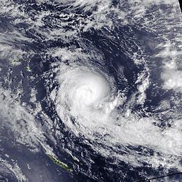
Severe Tropical Cyclone Tia was the first of six tropical cyclones to affect Vanuatu, during the 1991–92 South Pacific cyclone season. The system was first noted within the South Pacific convergence zone as a small tropical depression on November 13, to the northeast of the Solomon Islands. Over the next few days the system gradually developed further within an area of light winds in the upper troposphere, before it was named Tia early on November 16. Later that day due to a developing northerly steering current, the system slowed down and undertook a small anticlockwise loop before starting to move towards the southwest and rapidly intensify. After rapidly intensifying throughout November 16 and 17, Tia passed within 55 km (35 mi) of the Solomon Island: Anuta at around 1800 UTC on November 17, before passing near Tikopia Island six hours later. As Tia moved near Tikopia, the system reached its peak intensity as a category 3 severe tropical cyclone, with 10‑minute sustained windspeeds of 140 km/h (85 mph).
Contents
During November 18, due to cooler waters and increased wind shear, Tia started to weaken as it moved southwards under the influence of a strengthening upper-level northerly wind flow. Over the next 24 hours, the system continued to move southwards and passed within 150 km (95 mi) of Vanuatu's Banks Islands, while gradually weakening further. Tia subsequently degenerated into a tropical depression during November 20, before it was last noted the next day as it crossed a part of its former track, where it had been producing hurricane-force wind speeds a few days earlier. While it was active Tia directly affected the Solomon Islands and Vanuatu, while it indirectly affected Kiribati. The Solomon Island of Tikopia was the worst affected island, after more than 1000 people were left homeless on the island and 90% of all dwellings were destroyed. Damage was minimal in Vanuatu, and was mainly confined to crops and fruit trees on the Banks and Torres Islands. After this usage of the name Tia, the name was retired and withdrawn from use on the tropical cyclone naming lists.
Meteorological history
A small tropical depression developed within the South Pacific convergence zone, to the northeast of the Solomon Islands during November 13. During that day the system moved towards the south-west, before it sharply turned towards the east early the next day, as an equatorial westerly wind burst took place to the north of the cyclone. The depression subsequently gradually developed further, within an area of light winds in the upper troposphere and sea-surface temperatures of over 30 °C (86 °F). Early on November 15, the United States Joint Typhoon Warning Center initiated advisories on the depression and designated it as Tropical Cyclone 03P, after it had become equivalent to a tropical storm. During that day the system's upper level outflow characteristics became more favourable for further development, before the system was named Tia by the Fiji Meteorological Service TCWC Nadi named the system Tia early the next day after the system had developed into a category one tropical cyclone on the Australian tropical cyclone intensity scale. When it was named, Tia moving slowly and was located about 250 nmi (465 km) to the northeast of the Santa Cruz Islands, before the JTWC reported at around 0600 UTC that Tia had become equivalent to a category one hurricane on the Saffir–Simpson hurricane scale with 1‑minute sustained windspeeds of 120 km/h (75 mph). Around this time, because of a developing northerly steering current, Tia slowed down and undertook a small anticlockwise loop, before starting to move towards the southwest and rapidly intensify.
After rapidly intensifying throughout November 16 and 17, Tia passed within 55 km (35 mi) of Anuta Island at around 1800 UTC on November 17, before passing near Tikopia Island six hours later. As Tia moved near Tikopia, TCWC Nadi reported that the system had reached its peak intensity as a category 3 severe tropical cyclone, with sustained windspeeds of 140 km/h (85 mph). The JTWC followed suit six hours later and reported that the cyclone had peaked as a category 2 equivalent hurricane with sustained windspeeds of 175 km/h (110 mph). By 1800 UTC on November 18, due to cooler waters and increased wind shear, Tia started to weaken as it moved southwards under the influence of a strengthening upper-level northerly wind flow. Over the next 24 hours, the system continued to move southwards and passed within 150 km (95 mi) of Vanuatu's Banks Islands, while gradually weakening further before moving to the southeast under the influence of strong upper level northwesterlies. By 0000 UTC on November 20, Tia had weakened into a category one tropical cyclone on the Australian Scale and became slow moving while located about 370 km (230 mi) to the east of Port Villa in Vanautu. During that day the system turned and moved towards the northwest, before TCWC Nadi reported later that day at 1200 UTC, that Tia had weakened below tropical cyclone intensity. However, the JTWC monitored the system as a tropical cyclone for another 24 hours, before issuing their final advisory on the system at 1200 UTC as the system had weakened below tropical cyclone intensity. Tia was subsequently last noted by TCWC Nadi and JTWC later that day as it crossed a part of its former track, where it had been producing hurricane-force windspeeds a few days earlier.
Preparations and impact
Apart from several smaller islands no major inhabited islands lied in the path of Tia, while no deaths were associated with the system. After this usage of the name Tia, the name was retired and withdrawn from use on the tropical cyclone naming lists.
Solomon Islands
During November 17, warnings were issued by the Solomon Islands Meteorological Service for parts of Temotu Province in the Solomon Islands, after it became apparent that Tia was moving towards the eastern most islands of Anuta and Tikopia. During that day the system affected the province and came to within 55 km (35 mi) of Anuta at around 1800 UTC on November 17, before passing near to Tikopia six hours later. The southern most Solomon Island of Tikopia was the worst affected island, with 90% of all dwellings destroyed and the remaining 10% either having walls destroyed or roofs blown off. As a result, more than 1000 people were left homeless on the island, which was declared a disaster area by the Solomon Islands National Disaster Council. The cyclone also destroyed seven of the eight church buildings and all but one of the classroom buildings belonging to the two primary schools. Food crops were destroyed with all coconut trees either blown down or uprooted. High seas and waves caused extensive damage to the coasts and flooded low-lying areas, which damaged the taro, other food crops and the water supply on the island due to salt spray. Sustained windspeeds of 120 km/h (75 mph), wind gusts of 172 km/h (105 mph) and a minimum pressure of 987.9 hPa (29.17 inHg) were all reported by the automatic weather station on Anuta.
Other islands
On November 16, the Kiribati islands suffered the side-effects of Cyclone Tia, with several houses in Tarawa and seaweed farms damaged. Late on November 17, TCWC Nadi started to release special advisories for Vanautu after it had become clear that the systems south-southwest movement, would bring the cyclone sufficiently close to the Banks and Torres Islands to cause either gale or storm force winds. Over the next 24 hours, TCWC Nadi continued to issue these bulletins as the system moved southwards and brought gale force winds to Maewo, Pentecost and the Banks Islands before they issued the final advisory early on November 19. Tia was the first of six tropical cyclones to affect Vanuatu during the 1991–92 South Pacific cyclone season, and caused minor damage that was mainly confined to houses, crops and fruit trees on the Banks and Torres Islands. Within the Banks Islands a church was flattened, several roads were blocked and a man was slightly injured by flying debris.