
Founded December 3, 1832 Largest city Dallas Time zone Eastern: UTC-5/-4 Area 813.3 km² County seat Dallas Cities Dallas, Hiram | Named for John Paulding Congressional district 14th Website www.paulding.gov Population 146,950 (2013) Unemployment rate 5.1% (Apr 2015) | |
 | ||
Rivers Richland Creek, Sweetwater Creek, Raccoon Creek Points of interest White Oak Park, Taylor Farm Park, Mt Tabor Park, Burnt Hickory Park, Ben Hill Strickland Sr Memor | ||
Paulding County is a county located in the northwestern part of the U.S. state of Georgia. As of the 2010 census, the population was 142,324. The county seat is Dallas.
Contents
- Map of Paulding County GA USA
- History
- Geography
- Adjacent counties
- Secondary highways
- 2000 census
- 2010 census
- Recreation
- Incorporated Cities
- Unincorporated Communities
- Notable residents
- References
Map of Paulding County, GA, USA
Paulding County is included in the Atlanta-Sandy Springs-Roswell, GA Metropolitan Statistical Area. It is in Georgia's 14th congressional district.
The Paulding County Courthouse (Dallas, Georgia) is listed on the National Register of Historic Places.
History
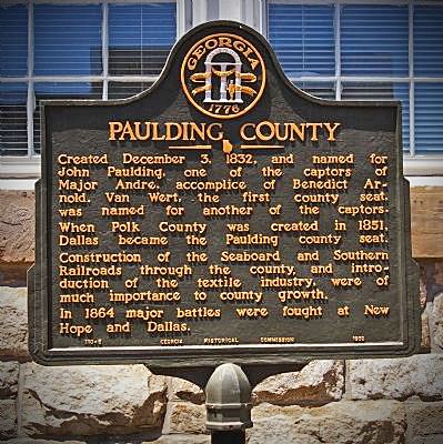
Paulding County was created from Cherokee County by an act of the Georgia General Assembly on December 3, 1832. In 1851, a portion of Paulding County was used to help create Polk County. Other portions of Paulding County were annexed to neighboring counties (Campbell, Carroll, Cobb, Douglas, Haralson, and Polk) between 1832 and 1874. Between 1850 and 1874, Paulding County was expanded through annexation of parts of Carroll, Cobb, Douglas, and Polk counties.
The County is named after John Paulding (October 16, 1758 – February 18, 1818), who was famous for the capture of the British spy Major John André in 1780 during the American Revolution. André was on a mission carrying secret papers from Benedict Arnold when he was captured.
Geography
According to the U.S. Census Bureau, the county has a total area of 314 square miles (810 km2), of which 312 square miles (810 km2) is land and 2.1 square miles (5.4 km2) (0.7%) is water. The Tallapoosa River originates in Paulding County.
The southeastern portion of Paulding County, from just north of Hiram to north of Villa Rica, is located in the Middle Chattahoochee River-Lake Harding sub-basin of the ACF River Basin (Apalachicola-Chattahoochee-Flint River Basin). The very western portion of the county, centered on State Route 101, is located in the Upper Tallapoosa River sub-basin of the ACT River Basin (Coosa-Tallapoosa River Basin), with the majority of the central and northern portions of Paulding County located in the Etowah River sub-basin of the same ACT River Basin.
Adjacent counties
Secondary highways
2000 census
As of the census of 2000, there were 81,678 people, 28,089 households, and 22,892 families residing in the county. The population density was 261 people per square mile (101/km²). There were 29,274 housing units at an average density of 93 per square mile (36/km²). The racial makeup of the county was 90.59% White, 6.96% Black or African American, 0.30% Native American, 0.40% Asian, 0.03% Pacific Islander, 0.57% from other races, and 1.16% from two or more races. 1.71% of the population were Hispanic or Latino of any race.
There were 28,089 households out of which 46.20% had children under the age of 18 living with them, 68.30% were married couples living together, 9.00% had a female householder with no husband present, and 18.50% were non-families. 14.60% of all households were made up of individuals and 3.80% had someone living alone who was 65 years of age or older. The average household size was 2.89 and the average family size was 3.20.
In the county, the population was spread out with 30.70% under the age of 18, 7.60% from 18 to 24, 38.40% from 25 to 44, 17.40% from 45 to 64, and 5.90% who were 65 years of age or older. The median age was 31 years. For every 100 females there were 100.20 males. For every 100 females age 18 and over, there were 96.80 males.
The median income for a household in the county was $52,161, and the median income for a family was $56,039. Males had a median income of $38,637 versus $27,341 for females. The per capita income for the county was $19,974. About 4.00% of families and 5.50% of the population were below the poverty line, including 5.60% of those under age 18 and 9.50% of those age 65 or over.
Paulding County Georgia is ranked 7th (2007 Census) in population growth among the United States. Being the 2nd Fastest growing county in Georgia. Also the 2nd fastest growing county in Metro Atlanta.
2010 census
As of the 2010 United States Census, there were 142,324 people, 48,105 households, and 38,103 families residing in the county. The population density was 455.8 inhabitants per square mile (176.0/km2). There were 52,130 housing units at an average density of 167.0 per square mile (64.5/km2). The racial makeup of the county was 77.7% white, 17.1% black or African American, 0.9% Asian, 0.3% American Indian, 1.7% from other races, and 2.3% from two or more races. Those of Hispanic or Latino origin made up 5.1% of the population. In terms of ancestry, 14.7% were Irish, 11.6% were American, 11.2% were German, and 10.4% were English.
Of the 48,105 households, 47.7% had children under the age of 18 living with them, 61.5% were married couples living together, 12.8% had a female householder with no husband present, 20.8% were non-families, and 16.6% of all households were made up of individuals. The average household size was 2.94 and the average family size was 3.30. The median age was 33.8 years.
The median income for a household in the county was $62,348 and the median income for a family was $67,117. Males had a median income of $50,114 versus $37,680 for females. The per capita income for the county was $23,450. About 7.0% of families and 8.2% of the population were below the poverty line, including 9.4% of those under age 18 and 11.8% of those age 65 or over.