
Population 649 2001 UK census | Post town HOPE VALLEY Local time Monday 11:22 AM | |
 | ||
Weather 7°C, Wind NW at 21 km/h, 80% Humidity Points of interest | ||
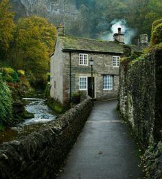
Castleton derbyshire england 21st august 2014
Castleton is a village in the High Peak district of Derbyshire, England. The village lies within the Peak District at the western end of the Hope Valley on the Peakshole Water, a tributary of the River Noe. The village is situated between the areas known as the Dark Peak (to the north) and the White Peak (to the south). Castleton's population was 649 according to the 2001 census, reducing slightly to 642 at the 2011 Census.
Contents
- Castleton derbyshire england 21st august 2014
- Map of Castleton Hope Valley UK
- History
- Geography
- Roads
- Public transport
- Tourism
- Events
- Famous people
- Walking
- In fiction
- References
Map of Castleton, Hope Valley, UK
History
Castleton village was mentioned as Pechesers in Domesday Book in 1086 where "Arnbiorn and Hundingr held the land of William Peverel's castle in Castleton". This land and Peverel's castle were amongst the manors belonging to William Peverel that also included Bolsover and Glapwell.
St Edmund's Norman church was restored about 1837. It has late 13th-century tracery and an ashlar-faced Perpendicular tower. Its box pews are dated 1661, 1662, 1663 and 1676.
A medieval leper hospital (the Hospital of Saint Mary in the Peak) is thought to have been on the eastern boundary of Castleton, though some locals believe it to have been just south of the Speedwell Cavern footpath from the village. Sheffield University archaeologists are investigating ‘Castle of the Peak’, which was reputedly founded by the wife of one of the William Peverels before 1153, and continued until about the 1543 Dissolution. They say the earliest documents referring to Spital Field are a grant and a Charter from the early 14th century. They are also investigating the 12th-century planned town at the foot of the castle hill.
Castleton later prospered from lead mining; the Odin Mine, one of the oldest lead mines in the country, is situated 1.5 kilometres (0.9 mi) west of the village (see also Derbyshire lead mining history). This created and enlarged local caverns, four of which are now open to the public as Peak Cavern, Blue John Cavern, Speedwell Cavern and Treak Cliff Cavern. A small amount of Blue John is mined locally.
Since the 1920s the main mineral industry in the area has been cement. Hope Cement Works is closer to Hope, but its quarry is closer to Castleton.
Geography
Castleton is situated between the gritstone plateau of the Dark Peak to the north and the gentler limestone scenery of the White Peak to the south. It lies at the western end of the Hope Valley and consequently is surrounded on three sides by hills. Most prominent is the ridge to the north. This is called Great Ridge; it runs east from Mam Tor to Back Tor and Lose Hill, via the pass (hause) of Hollins Cross, where paths from many directions converge and cross over to Edale. Alexander von Humboldt visited caves near Castleton and Buxton in June 1790 to investigate the region's geological structures.
Roads
Castleton used to be on the A625 road from Sheffield to Chapel-en-le-Frith, on the way to Manchester. Leaving Castleton, the western road used to go over Mam Tor, but after continual collapses and repairs (Mam Tor is called the "Shivering Mountain" because of its very loose shales), it was eventually abandoned.
The only westbound exit from Castleton is now the unclassified road over the narrow Winnats, more frequently called "Winnats Pass". This road is very narrow and steep and unsuitable for heavy vehicles or high volumes. Road signage has been designed to discourage through traffic by showing only local destinations. Thus, most traffic enters and leaves the village on the eastern (Hope-Hathersage-Sheffield) road; for traffic going west, that involves a long diversion via the villages of Bradwell and Peak Forest.
Public transport
Castleton has a small bus station from where buses depart hourly to Sheffield (services 272 [2] and 4 times a day via Ladybower to Sheffield (273 & 274 [3]) and to Tideswell and Bakewell (service 173 [4]). A few less frequent bus services also serve Castleton, including services 68 [5] to Buxton and 174 [6] from Baslow, which run just once a day, 200 [7] on schooldays to Chapel-en-le-frith and Edale and 276 [8] on Fridays to Chesterfield.
There is no railway station, but Hope station is about 3 kilometres (1.9 mi) away, and train tickets to Hope and Edale are valid on connecting buses to Castleton.
Tourism
Castleton attracts large numbers of tourists, and there are many pubs (some with accommodation), tea shops and guest houses to supply their needs. There is also a large car park, an information centre, several outdoors shops and a youth hostel. Many schools visit the area for educational studies such as GCSE fieldwork. It is also a major walking centre, where routes up Cave Dale, Winnats Pass, Mam Tor and Hollins Cross meet. There are four "show caves" to visit (one of them including an underground boat ride) and at least one of them is open all year. Castleton has a combined post office and general shop.
Events
On Castleton Garland Day (Oak Apple Day – 29 May), a Garland King is paraded around the streets wearing an extremely large garland of flowers, followed by local girls dressed in white with flowers. The village is also famous for its display of Christmas lights and decorations during the festive season.
Famous people
Walking
Castleton is popular with walkers: there is plenty of accommodation, and there are many public footpaths leading from the village. There are easy walks along the river to Hope, Brough, Bamford and (rather further) Hathersage, and there is a short strenuous walk up onto the Great Ridge, where views can be enjoyed before descending to Edale or returning to Castleton. Hayfield is a short day's walk away beyond Rushup Edge. A two- or three-day trail, the Limestone Way, starts in Castleton and runs south down Cave Dale (past the rear of the castle) before climbing out of the village and heading for Monyash, Youlgreave, and Matlock.
In fiction
The village was featured in episode 3 of Most Haunted: Midsummer Murders where the team "investigates" the 18th century murder of an engaged couple. Much of the "investigation" takes place in Speedwell Cavern. One of the conspirators, James Ashton, is said to have confessed to the murders on his deathbed after being haunted by the dead couple. He also implicated others involved. Castleton also featured in national news reports in the early 1980s following the murder of Susan Renhard near the battlements of Peveril Castle.
The local underground caves were used as the filming location for the underworld, ruled by the evil Lady of the Green Kirtle (played by Barbara Kellerman), in the 1990 BBC adaptation of The Silver Chair (one of the Narnia books written by C.S. Lewis). Cave Dale features in the films The Princess Bride (1987) and The Other Boleyn Girl (2008).
The town is also featured briefly in the play The Devil is an Ass by Ben Jonson, first performed in 1616.