
Population 1,503 (2011) Civil parish Glapwell Local time Tuesday 2:26 PM | OS grid reference SK480660 Sovereign state United Kingdom | |
 | ||
Weather 14°C, Wind W at 29 km/h, 66% Humidity | ||
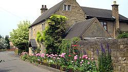
Glapwell is a village located either side of the main A617 road in north east Derbyshire, between the towns of Chesterfield (7 miles) and Mansfield (5 miles), although the nearest small town centre is Bolsover (3 miles to the north). With 1,467 residents, increasing to 1,503 at the 2011 Census, Glapwell is situated on and atop a very steep hill adjoining with the next village of Bramley Vale at the bottom.
Contents
Map of Glapwell, Chesterfield, UK
History
This village is listed in the Domesday Book. In 1086, the book notes that Serb holds this for William Peverel.
"In Clapwell, Liefric had one carucate of land to the geld. There is land for as two ploughs. There eight villans have 6 ploughs... Serb now holds it."
Glapwell colliery closed in the 1970s and the site is owned by a private company manufacturing industrial fencing and access solutions, Eve Trakway. There is no overall dominant industry in the area, with most of the jobs being out of the village.
Amenities
The village has a local shop\post office and two pub/restaurants: The Young Vanish,(an unusual name derived from that of a 19th-century champion race horse), and the Plug and Feathers (previously a Ma Hubbards venue) formerly and traditionally the Glapwell Hotel, known by many local as "The New Un"). The Hotel was one of the first places that train travellers would see when leaving the nearby LMS train station, and was in fact the local Station Hotel. The station itself closed in the 1930s.
The social club, The Rowthorne, closed on December 18, 2011 and the site has been redeveloped for housing. Another long standing landmark that also disappeared in 2011 was Staleys, the local garage. Glapwell Garden Centre stands on the site of the former Glapwell Hall, the former residence of the Hallowes and now extinct Jackson families
Nearby is Hardwick Hall, an Elizabethan mansion situated in a commanding position high on the same hill as Glapwell, operated by the National Trust. Access to the grounds and Hall was possible via Rowthorne Lane in Glapwell but this was stopped-up in the early 1990s as a planning condition with Health and Safety considerations due to undesirable traffic in a residential area. Access is now only from the bottom of the hill across the M1 motorway near to the village of Heath, via the Mill Lane entrance and old coaching road approach to the mansion from the restored National Trust working Stainsby Mill.
The local football team Glapwell F.C. played their home games at Hall Corner in the north of the village before folding in 2016. The cricket team Glapwell Colliery Cricket Club play their home games at Park Avenue.