
Population 1,416 (2011) Post town HOPE VALLEY Dialling code 01433 | Sovereign state United Kingdom Postcode district S33 Local time Thursday 12:06 PM | |
 | ||
Weather 6°C, Wind W at 27 km/h, 81% Humidity | ||
Fun fly day at bradwell derbyshire
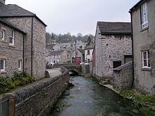
Bradwell is a village and civil parish in the Derbyshire Peak District of England. The population of the civil parish taken at the 2011 Census was 1,416. It lies south of the main body of the Hope Valley but is usually included among its settlements.
Contents
- Fun fly day at bradwell derbyshire
- Map of Bradwell UK
- History
- Economy
- Notable residents
- Climate
- References
Map of Bradwell, UK
Hazelbadge Hall lies immediately south of the village.
History
A few Roman remains have been found in the village, associated with the nearby Navio fort at Brough-on-Noe, including a Roman bath. Grey Ditch is a medieval earthwork and a Scheduled Monument. The village grew again in the eighteenth century around lead mining.
Economy
As with many Peak District villages, Bradwell has become a settlement for commuters and retirees. The other sources of income are the landmark local cement factory, pubs, B&Bs, an eponymous locally made ice cream, and some subsidised farming. The Bagshaw Cavern former show cave is now only open by appointment.
Notable residents
Climate
Climate in this area has mild differences between highs and lows, and there is adequate rainfall year round. The Köppen Climate Classification subtype for this climate is "Cfb". (Marine West Coast Climate/Oceanic climate).