
Population 316 (2001 Census) | OS grid reference SK122856 Sovereign state United Kingdom Local time Saturday 5:33 AM | |
 | ||
Weather 8°C, Wind S at 13 km/h, 88% Humidity Points of interest Mam Tor, Treak Cliff Cavern, Blue John Cavern, Speedwell Cavern, Winnats Pass | ||
Derbyshire dales peak district edale hope valleys hd 2012 england
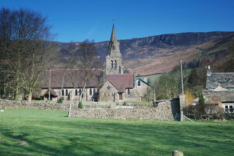
Edale /ˈiːdeɪl/ is a village and civil parish in the Derbyshire Peak District, in the Midlands of England. The population in 2001 was 313 increasing to 353 at the 2011 Census. The Parish of Edale, area 7,030 acres (2,840 ha), is in the Borough of High Peak.
Contents
- Derbyshire dales peak district edale hope valleys hd 2012 england
- Map of Edale Hope Valley UK
- Trains at edale hope valley 10 11 12
- History
- Cotton mill
- Countryside
- Amenities
- Famous residents
- References
Map of Edale, Hope Valley, UK
Edale is best known to walkers as the start (or southern end) of the Pennine Way, and to less ambitious walkers as a starting point for evening or day walks, accessible by public transport from Sheffield or Manchester and with two pubs serving real ale and food.
Trains at edale hope valley 10 11 12
History
As spelt, the name is first recorded in 1732. Earlier recorded versions of the name are Aidele (1086), Heydale (1251), Eydale (1275), Eydal (1285) and Edall (1550).
Historically, Edale was the name of the valley of the River Noe. From the Norman Conquest of England it was in the royal Forest of High Peak and at its centre is the Edale Cross, which marked the boundary of the three wards at the Forest, Campana, Hopedale and Longdendale. Settlement in the valley consists of several booths, originally established in the 13th century as 'vaccaries' (cattle farms) along the valley of the River Noe, which have since developed into the hamlets of Upper Booth (once Crowdenley Booth and Over Booth), Barber Booth (once Whitmorely Booth), Grindsbrook Booth, Ollerbrook Booth and Nether Booth (also known as Lady Booth and, formerly, Lower Booth).
When the Hope Valley Line opened linking Sheffield and Manchester Piccadilly, the railway station to the south of Grindsbrook Booth was named "Edale", and the name came to be used for the settlements in the parish, rather than the valley as a whole. The valley is usually now referred to as the "Vale of Edale" or, much less frequently, as the "Noe Valley".
Cotton mill
Edale is the site of an historic cotton mill built in 1795 on the site of a corn mill and tannery by Nicholas Cresswell in partnership with James Harrison, Robert Blackwell and Joseph Fletcher. Workers were brought in from the towns and accommodated in cottages and in a nearby house called Skinner's Hall. Many of the women workers walked each day from Castleton over the thousand-foot Hollins Cross pass. The mill continued spinning cotton until around 1940 but then fell into disuse. It was restored in the early 1970s by the Landmark Trust who have since sold off all of the apartments.
Countryside
As well as being the start of the Pennine Way (the official start is the Old Nag's Head, a former smithy dating back to 1577), the village is surrounded by walking country which is excellent in its own right. The village is surrounded by hills: the plateau of Kinder Scout to the north, where the highest point in the parish is found, the Great Ridge (running west to east between Rushup Edge over Mam Tor to Lose Hill) to the south and east, Win Hill to the east (outside the parish), and Dalehead (Brown Knoll, Horsehill Tor and Colborne) to the west. Almost the entire parish is over 200m above sea level; only along the River Noe east from Carr House does the elevation drop below this level.
The bed and banks of the River Noe from Barber Booth upstream to approximately the 320-metre (1,050 ft) contour constitute the Edale SSSI, cited for geological interest. The "important exposures" of the Edale Shales here contain fossils of technical interest.
Amenities
There is a youth hostel about a mile from the village centre, several B&Bs, and both pubs also provide accommodation. The pubs also provide food, and there are two cafés. In 2006 a new information and visitor centre was opened at Fieldhead. It was developed by the Moors for the Future Partnership and is owned and operated by the Peak District National Park Authority. Edale is also a popular camping village with two major campsites and numerous others in the surrounding area.
The train service is reasonably frequent for such a rural area, and there is a limited bus service. The short but narrow, twisting and dead-end road to the village centre is not suitable for visitors' cars, and parking in the village centre is almost impossible. However, there is a large pay-and-display car park near the village hall, and parking for rail users at the railway station. Additional parking near the station is provided at busy times by the Parish Council.