
Population 202 (2011 census) Mean max temp Mean min temp Local time Thursday 4:06 AM | Postcode(s) 5204 State electorate(s) Finniss Postal code 5204 | |
 | ||
Weather 17°C, Wind SE at 11 km/h, 80% Humidity Points of interest Heysen Trail, Morgans Beach, Fishery Beach | ||
Cape Jervis is a town in the Australian state of South Australia located near the western tip of Fleurieu Peninsula on the southern end of the Main South Road approximately 88 kilometres (55 mi) south of the state capital of Adelaide.
Map of Cape Jervis SA 5204, Australia
It is named after the headland at the western tip of Fleurieu Peninsula which was named by Matthew Flinders after John Jervis, 1st Earl of St Vincent on 23 March 1802.
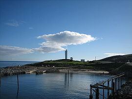
It overlooks the coastline adjoining the following three bodies of water - Gulf St Vincent, Investigator Strait and Backstairs Passage. It also overlooks the following facilities both located at the headland of Cape Jervis - the Cape Jervis Lighthouse and the port used by Kangaroo Island SeaLink who operates the ferry service to Penneshaw on Kangaroo Island.
In the 2011 census, the population was 202 and which is reported as growing rapidly, with a new estate (Cape Jervis Heights) situated behind the main town. Cape Jervis is located within the local government area of the District Council of Yankalilla.
Cape Jervis is the starting point for the Heysen Trail, a walking track of 1,200 kilometres (750 mi) length which finishes at Parachilna Gorge in the Flinders Ranges. Venues of interest to visitors to the town include the Deep Creek Conservation Park, the Talisker Conservation Park and two nearby beaches - Morgan's Beach (with the remains of the trawler Ellen) and Fisheries Beach (with remains of an old whaling station). Cape Jervis is also notable as a point of embarkment for fishing charters.