
- elevation 1,960 ft (597 m) Length 230 km Basin area 4,586 km² | - elevation 446 ft (136 m) Basin area 4,587 km² | |
 | ||
- average 3,177 cu ft/s (90 m/s) (mean for water years 1915-1983) - max 210,000 cu ft/s (5,947 m/s) March 1929 Mouths | ||
Best trout flies on tn s caney fork river
The Caney Fork River is a river that flows through central Tennessee in the United States, draining a substantial portion of the southwestern Cumberland Plateau and southeastern Highland Rim regions. It is a major tributary of the Cumberland River, and is part of the Cumberland, Ohio and Mississippi basins. The river is 143 miles (230 km) long, and its watershed covers 1,771 square miles (4,590 km2) in eleven counties. Monterey, Baxter, Sparta, Smithville, McMinnville, Altamont, Spencer and Gordonsville are among the towns that are at least partially drained by the river.
Contents
- Best trout flies on tn s caney fork river
- Map of Caney Fork Tennessee USA
- Caney fork river tn fly fishing amazing day kayak fly fishing
- GeographyEdit
- References
Map of Caney Fork, Tennessee, USA
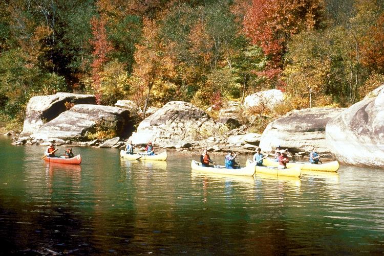
The Caney Fork flows through two impoundments— Center Hill Lake and Great Falls Lake— both of which create sizeable artificial lakes. The river's basin is home to numerous protected lands and recreational areas, including five state wilderness areas, six interpretive areas, and a wildlife management area. Two state parks— Edgar Evins State Park and Rock Island State Park— are located along the river, and three others— Fall Creek Falls State Park, Burgess Falls State Park and South Cumberland State Park— are located within its basin. The river is a popular stream for canoeing and kayaking.
The name "Caney Fork" comes from the dense cane breaks that grew along the river's banks when European explorers first arrived in the area.
The river is a major drainage feature of the Cumberland Plateau and the largest tributary of the Cumberland River.
Tributaries include: Caney Creek, which drains Fall Creek Falls; Calfkiller River; Rocky River; Collins River, which flows into Great Falls Lake; Falling Water River, which is the location of Burgess Falls State Park and City Lake in Cookeville; Mine Lick Creek, among the large creeks flowing into Center Hill Lake; Indian Creek (in Putnam County); Smith Fork Creek; and Hickman Creek, near Gordonsville, Tennessee.
Caney fork river tn fly fishing amazing day kayak fly fishing
GeographyEdit
The Caney Fork rises in Cumberland County about 6 miles (10 km) west-northwest of Crossville before flowing southwest and crossing into White County. In southeastern White County it descends off the Cumberland Plateau through a deep, steep gorge known as Scott's Gulf in a remote area west of Scott Pinnacle, a locally-known mountain. Farther downstream, near the Dodson community, the stream becomes the line between White County and Van Buren County. It receives the flow of the Calfkiller River and several minor tributaries.
At the confluence of the Caney Fork, the Collins River and the Rocky River is Great Falls Lake. This reservoir is impounded by Great Falls Dam, a project of the former Tennessee Electric Power Company now owned and operated by the Tennessee Valley Authority, the only dam outside of the Tennessee River drainage system directly operated by it. This dam impounds a very small but very deep lake due to the depth of the gorges carved by the rivers it impounds. This area was something of a resort area in the early 20th century when such projects were uncommon, especially in the southeastern United States, but other than a few cabins, there is little evidence of this today, as the area has been largely supplanted by larger, more modern developments. The dam is named for the Great Falls of the Caney Fork, caused by the descent of the stream off of the Highland Rim to the level of the Nashville Basin. Here is Rock Island State Park, developed on the site of former woolen mills in the 19th century well predating the electrical development. (This area was used for a considerable number of exterior shots and stunts in the Sylvester Stallone film, The Specialist.)
At the foot of Great Falls Dam the water is usually slack except during periods of high discharge due to the influence of the U. S. Army Corps of Engineers Center Hill Dam project, developed in the late 1950s. Unlike Great Falls Dam, this project flooded thousands of acres of land previously devoted to agriculture and several small communities. It is crossed by a particularly scenic bridge on State Route 56. Along its shores is Edgar Evins State Park, named for the father of the area's former Congressman, Joe L. Evins, former chairman of the House Appropriations Committee. This area is in DeKalb County.
Below Center Hill Dam, the stream crosses into Smith County and is bridged by Interstate 40 no less than five times. This downstream section is annually stocked with Rainbow, Brown, and Brook Trout by the Tennessee Wildlife Resources Agency and is considered to be one of the best trout rivers in the state. A final bridge is on U.S. Route 70N near the Elmwood community; the river's mouth into the Cumberland River which also considered to be a world class Striper fishery is almost directly opposite the Smith County seat of Carthage.