
Founded 1799 Population 19,074 (2013) Unemployment rate 5.3% (Apr 2015) | Area 841.7 km² | |
 | ||
Rivers Cumberland River, Caney Fork River, Smith Fork Creek | ||
Underground elmwood mine smith county tennessee 1997 part 3 of 4
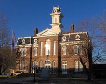
Smith County is a county located in the U.S. state of Tennessee. As of the 2010 census, the population was 19,166. In the section known as Middle Tennessee, its county seat is Carthage. The county was organized in 1799 and is named for Daniel Smith, a Revolutionary War veteran who made the first map of Tennessee and served as a United States senator.
Contents
- Underground elmwood mine smith county tennessee 1997 part 3 of 4
- Map of Smith County TN USA
- Underground elmwood mine smith county tennessee 1997 part 4 of 4
- History
- Geography
- Adjacent counties
- State protected areas
- Demographics
- Towns
- References
Map of Smith County, TN, USA
Smith County is part of the Nashville-Davidson–Murfreesboro–Franklin, TN Metropolitan Statistical Area.
Underground elmwood mine smith county tennessee 1997 part 4 of 4
History
Smith County was established in 1799 from a portion of Sumner County, and was named for Daniel Smith, a U.S. Senator and former Secretary of the Southwest Territory. The location of the county seat was hotly contested between Bledsoesborough (near modern Dixon Springs) and William Walton's ferry and tavern at the confluence of the Caney Fork and the Cumberland River. In 1804, voters chose Walton's site, and a town, named "Carthage," was platted the following year.
Smith County was the site of a large saltpeter mine. Piper Cave, located near Monoville, contains the poorly preserved remnants of dozens of saltpeter leaching vats. Most saltpeter mining in Middle Tennessee occurred during the War of 1812 and the Civil War, but the exact date of this operation is unclear.
Geography
According to the U.S. Census Bureau, the county has a total area of 325 square miles (840 km2), of which 314 square miles (810 km2) is land and 11 square miles (28 km2) (3.4%) is water. The county is located in a transition area between the rugged Highland Rim to the east and the flatter Nashville Basin to the west. The Caney Fork has its confluence with the Cumberland River in Carthage; these are the primary waterways flowing through the county. Cordell Hull Dam on the Cumberland is located near Carthage.
Adjacent counties
State protected areas
Demographics
As of the census of 2000, there were 17,712 people, 6,878 households, and 5,069 families residing in the county. The population density was 56 people per square mile (22/km²). There were 7,665 housing units at an average density of 24 per square mile (9/km²). The racial makeup of the county was 95.42% White, 2.53% Black or African American, 0.37% Native American, 0.17% Asian, 0.01% Pacific Islander, 0.59% from other races, and 0.93% from two or more races. 1.13% of the population were Hispanic or Latino of any race.
There were 6,878 households out of which 34.10% had children under the age of 18 living with them, 60.10% were married couples living together, 9.80% had a female householder with no husband present, and 26.30% were non-families. 23.40% of all households were made up of individuals and 11.10% had someone living alone who was 65 years of age or older. The average household size was 2.55 and the average family size was 3.00.
In the county, the population was spread out with 25.50% under the age of 18, 8.00% from 18 to 24, 30.00% from 25 to 44, 23.10% from 45 to 64, and 13.40% who were 65 years of age or older. The median age was 37 years. For every 100 females there were 97.00 males. For every 100 females age 18 and over, there were 92.40 males.
The median income for a household in the county was $35,625, and the median income for a family was $41,645. Males had a median income of $30,853 versus $22,133 for females. The per capita income for the county was $17,473. About 10.30% of families and 12.20% of the population were below the poverty line, including 14.70% of those under age 18 and 14.80% of those age 65 or over.