
Created 1935 | Area 26,000 acres (110 km) Phone +1 423-881-5298 | |
 | ||
Hours Open today · 7AM–10PMSunday7AM–10PMMonday7AM–10PMTuesday7AM–10PMWednesday7AM–10PMThursday7AM–10PMFriday7AM–10PMSaturday7AM–10PM | ||
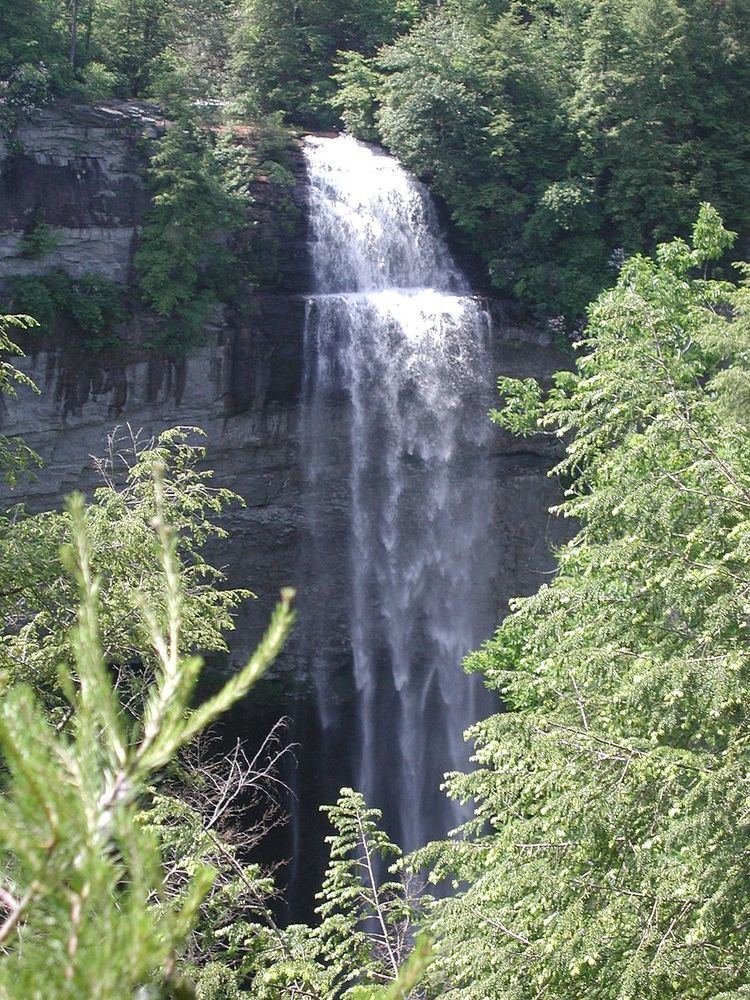
Fall Creek Falls State Resort Park is a state park in Van Buren and Bledsoe counties, in the U. S. state of Tennessee. The over 26,000-acre (110 km2) park is centered on the upper Cane Creek Gorge, an area known for its unique geological formations and scenic waterfalls. The park's namesake is the 256-foot (78 m) Fall Creek Falls, the highest free-fall waterfall east of the Mississippi River.
Contents
Campground review fall creek falls state park in spencer tn
SettingEdit
The Cane Creek Gorge presents as a large gash in the western edge of the Cumberland Plateau, stretching for some 15 miles (24 km) from the Cane Creek Cascades to Cane Creek's mouth along the Caney Fork. Cane Creek rises atop Little Mountain — which lines the plateau's eastern edge above Sequatchie Valley — and winds northward across the plateau.
Just beyond its source, Cane Creek slowly gains strength as it absorbs Meadow Creek and several smaller streams. As the creek enters the gorge, it drops several hundred feet in less than a mile, including 45 feet (14 m) over Cane Creek Cascades and 85 feet (26 m) over Cane Creek Falls. A few hundred meters north of Cane Creek Falls, Rockhouse Creek spills 125 feet (38 m) over a plunge waterfall into the same plungepool. Over the next half-mile, Cane Creek absorbs Fall Creek and Piney Creek, both of which enter from smaller gorges to the immediate west. During this stretch, part of the creek disappears underground into limestone sinks, and reemerges at a spring known as "Crusher Hole." Cane Creek continues to lose elevation before steadying near its confluence with Dry Fork. Beyond Dry Fork, the creek gradually descends to the Highland Rim, where it empties into the Caney Fork.
The man-made Fall Creek Falls Lake, controlled by a dam, assures continuing flow of water to Fall Creek Falls. The lake dominates the park's southern section.
WaterfallsEdit
OverlooksEdit
CavesEdit
Along with waterfalls and overlooks, this state park has more caves than any other park in the eastern U.S., except for Mammoth Cave National Park. All Park caves are currently closed in an effort to prevent the spread of White Nose Syndrome (WNS) in bats.
HistoryEdit
The plateau areas above the Cane Creek Gorge are characterized by poor soil and weak resource potential, both exacerbated by the area's limited accessibility (by the 1920s, no major railroads and one crude highway passed between Pikeville and Spencer). In the early twentieth century, this section of Van Buren County still had only a handful of farms and no major coal mining or logging operations. Local historian Arthur Weir Crouch, referring to Fall Creek Falls, wrote, "In the beginning and for many years it was a true wilderness area."
The few residents who lived in the Cane Creek area were often at the mercy of the creek, which, like most of the Upper Caney Fork watershed, was prone to flash flooding. The Good Friday Flood of 1929, the most devastating of these floods, caused the Caney Fork and its tributaries to swell to record volumes and wiped out dozens of mills, houses, and bridges. Lawson Fisher, who operated a grist mill at the head of Cane Creek Falls at the time of the flood, recalled being awakened that night by the roar of the creek's rising waters. Racing into the mill to save the mill's account books, Fisher later testified:
I had taken perhaps four or five steps when I felt that old mill building quiver. I turned and ran for the door and stepped out on solid ground, and then turned around to see what was going to happen, but folks, it had already happened. The mill wasn't there. I could just see pieces of planking and timbers going over the falls and rushing on down into the valley of Cane Creek below.
Another resident recalled waking up to a cabin floor covered with several inches of water, and spending the night in the cabin loft watching helplessly as the water continued to rise. Several smaller farms in the lower part of the valley were completely destroyed. The Cane Creek Mill, which had stood above the falls since 1831, was never rebuilt.
The state parkEdit
In 1937, the U.S. government began purchasing the badly eroded land around Fall Creek Falls. The following year, the Works Progress Administration and the Civilian Conservation Corps began the work of restoring the forest and constructing park facilities. The National Park Service transferred ownership of the park to the State of Tennessee in 1944.
Millikan's Overlook is named after Glenn Millikan, who was head of the Department of Physiology at Vanderbilt University School of Medicine and son of Nobel Laureate Robert A. Millikan. Millikan was killed by a falling rock on May 25, 1947 while rock climbing "Buzzard's Roost," the cliff beneath the overlook.
In 2006, the State of Tennessee purchased 12,500 acres (51 km2) of land along the White-Van Buren County line, in the vicinity of Bledsoe State Forest. The purchase is part of an effort to create an unbroken corridor of publicly owned land between Fall Creek Falls State Park and Scott's Gulf, a few miles to the north in White County.
Park facilities and managementEdit
Fall Creek Falls State Park is open year-round and is managed by the Tennessee Department of Environment and Conservation.
Park facilities include an inn and conference center, restaurant, cabins, and campgrounds. The Fall Creek Falls Inn and Conference Center offers over 5,000 square feet of banquet space in five conference rooms, which will accommodate up to 400 people. The park has 30 cabins – 20 fishermen cabins and 10 landside cabins. The park has 222 campsites in five different areas. All sites have tables, grills, water, and electricity and are served by six bathhouses.
An 18-hole golf course, Olympic-sized swimming pool, and several miles of hiking trails and paved biking trails are available in the park.
In 2013–2014, the park underwent some minor renovations of its facilities. The landside cabins and fisherman cabins were updated, and a privately operated zip line was installed at the Village Green.
In the artsEdit
Artist Gilbert Gaul (1855–1919), who gained national acclaim for his Civil War illustrations, operated from a studio south of Spencer on land currently owned by the park.
Fall Creek Falls State Park was used as one of the primary filming locations for the Disney live action movie The Jungle Book:13 and the comic science fiction film Dr. Otto and the Riddle of the Gloom Beam, starring Jim Varney.:16 Scenes from the 1986 movie King Kong Lives, starring Linda Hamilton, were filmed in the area of Cane Creek Cascades and Cane Creek Falls.:16