
Country United States County Lake FIPS code 06-81358 Elevation 410 m Zip code 95485 Area code 707 | GNIS feature IDs 236896, 2409382 Area 4.369 km² Population 1,052 (2010) | |
 | ||
Tallman hotel in upper lake california
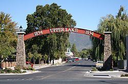
Upper Lake is a census-designated place (CDP) in Lake County, California, United States. Upper Lake is located 8 miles (13 km) north of Lakeport, at an elevation of 1345 feet (410 m). The population was 1,052 at the 2010 census, up from 989 at the 2000 census. The Habematolel Pomo of Upper Lake are headquartered here.
Contents
- Tallman hotel in upper lake california
- Map of Upper Lake CA USA
- 615 clover drive upper lake california
- History
- Geography
- Climate
- References
Map of Upper Lake, CA, USA
615 clover drive upper lake california
History
This community was formerly named Upper Clear Lake and Upperlake.
The settlement began in 1856, when William B. Elliott opened a blacksmith's shop.
The Upper Clear Lake post office opened in 1871, changed its name to Upper Lake in 1875, to Upperlake in 1905, and then back to Upper Lake in 1906.
Geography
According to the United States Census Bureau, the CDP has a total area of 1.7 square miles (4.4 km2), of which over 99% is land.
At the 2000 census, according to the United States Census Bureau, the CDP had a total area of 6.0 square miles (16 km2), of which, 5.8 square miles (15 km2) of it was land and 0.2 square miles (0.52 km2) of it (3.33%) was water.
The Hayville Sulphur Spring, formerly used medicinally, is located 5 miles (8 km) northwest.
Climate
Upper Lake has a Hot-summer Mediterranean climate (Csa) according to the Köppen climate classification system.