
Elevation 1,323 m Prominence 556 m | First ascent 1841 | |
 | ||
Topo map USGS Mount Saint Helena Similar Cobb Mountain, Mount Hood, Mount Konocti, Mount Vaca, Mount Diablo | ||
Hiking mount saint helena in robert louis stevenson state park
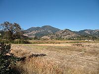
Mount Saint Helena (Wappo: Kanamota, "Human Mountain") is a peak in the Mayacamas Mountains with flanks in Napa, Sonoma, and Lake counties of California. Composed of uplifted 2.4-million-year-old volcanic rocks from the Clear Lake Volcanic Field, it is one of the few mountains in the San Francisco Bay Area to receive any snowfall during the winter.
Contents
- Hiking mount saint helena in robert louis stevenson state park
- Map of Mt St Helena California 95448 USA
- HistoryEdit
- References
Map of Mt St Helena, California 95448, USA
The mountain has five peaks, arranged in a rough "M" shape. Its highest point, North Peak, is in Sonoma County. The second-tallest, immediately east of the main summit, is the highest point in Napa County. The headwaters of the Napa River are on the southeast slope of Mount Saint Helena.
HistoryEdit
Mount Saint Helena has had an explosive history of pyroclastic flows that resulted in The Petrified Forest.
Mount Saint Helena was originally named Mount Mayacamas, but the name was changed after a Russian survey party ascended the peak in 1841 and left a copper plate on the summit inscribed with the date of their visit. The plate also bore the name of Princess Helena de Gagarin, wife of Count Alexander G. Rotchev, the commanding officer of Fort Ross.
Robert Louis Stevenson and Fanny Vandegrift Osbourne spent the summer of 1880 honeymooning in an abandoned mining camp on Mount Saint Helena. Stevenson's book The Silverado Squatters includes his experiences while living there. The mount is also described by Ambrose Bierce in his ghost story The Death of Halpin Frayser.
The peak is reachable by hiking trails leading from Robert Louis Stevenson State Park. The trails are approximately 6 miles long.