
Length 57.94 km | ||
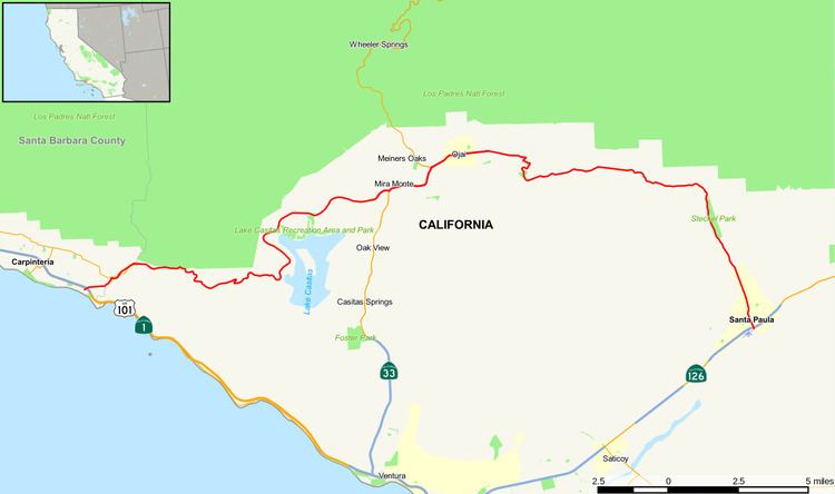 | ||
West end: SR 1 / US 101 in Carpinteria | ||
State Route 150 (SR 150) is a state highway in the U.S. state of California. It runs from Santa Paula to U.S. Route 101 near the Ventura/Santa Barbara County line. It is a two-lane road. There were some one-lane bridges near the western end of the route, but these were rebuilt to be two-lane bridges after flooding in 2005.
Contents
Map of CA-150, California, USA
This route is eligible for the State Scenic Highway System.
Route description
The eastern terminus is at State Route 126 in Santa Paula at the 10th Street junction. It runs on 10th Street, before branching off in a northwest direction from Santa Paula on Ojai-Santa Paula Road and serves as the major connector between the cities of Santa Paula and Ojai, running past Thomas Aquinas College. In the city of Ojai, it is called Ojai Avenue, and at the junction with State Route 33 (Maricopa Highway), it is co-signed with SR 33 until Meiners Oaks. The portion of the road between Ojai and Lake Casitas is called Baldwin Road and the portion between the lake and U.S. 101 is called Casitas Pass Road. SR 150 runs through the mountains west of Lake Casitas before descending towards the Pacific Ocean. It ends at US 101 in eastern Carpinteria. This part of the road is rural and is not used as a primary thoroughfare. State Route 33 is recommended to reach Ojai from U.S. 101.
The other names of Route 150 include Rincon Road (starts at U.S. Route 101 and ends at State Route 192), Casitas Pass Road (starts at Route 192 and ends at Santa Ana Road near Lake Casitas), Baldwin Road (starts at Santa Ana Road and ends at the south junction with Route 33), Ventura Avenue ( A Co-signed with Route 33), Ojai Avenue (starts at the north junction with Route 33 and ends at Reeves Road, approximately one mile east of the east limit of Ojai), Santa Paula/Ojai Road (starts at Reeves Road and ends at the north limit of the City of Santa Paula), Ojai Road (starts at the north limit of Santa Paula and ends at Santa Paula Street in Santa Paula) and 10th Street (starts on Santa Paula Street in Santa Paula and ends at Route 126).
History
The route was opened in 1897. Before the construction of US 101, it was part of the main highway between Los Angeles and Santa Barbara. Originally, State Route 150 followed the alignment of State Route 192 through the Santa Barbara foothills and climbed up San Marcos Pass via the present-day route of State Route 154 before heading west on State Route 246, passing through Santa Ynez, Solvang, and Buellton and ending in Lompoc at State Route 1 (Cabrillo Highway). The only current remnants of that routing are at the mileage signs for westbound State Route 150, which have the control city as Santa Barbara west of Santa Paula, even though SR 150 currently ends 12 miles (19 km) east of the city.
Major intersections
Except where prefixed with a letter, postmiles were measured on the road as it was in 1964, based on the alignment that existed at the time, and do not necessarily reflect current mileage. R reflects a realignment in the route since then, M indicates a second realignment, L refers an overlap due to a correction or change, and T indicates postmiles classified as temporary (for a full list of prefixes, see the list of postmile definitions). Segments that remain unconstructed or have been relinquished to local control may be omitted. The numbers reset at county lines; the start and end postmiles in each county are given in the county column.