
Existed: 1934 – present Length 65.11 km | East end: I-5 in Santa Clarita Constructed 1934 | |
 | ||
West end: SR 1 / US 101 in Ventura | ||
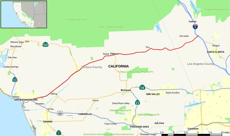
State Route 126 (SR 126) is a highway in Ventura and Los Angeles counties, California. The route runs from U.S. Route 101 in Ventura to Interstate 5 in Santa Clarita through the Santa Clara River Valley. The highway is an important connector highway in Ventura County, and serves as an alternate route into the Santa Clarita and San Fernando valleys, the High Desert of Antelope Valley, and Los Angeles.
Contents
Map of CA-126, California, USA
Route description
State Route 126 is the main route from Ventura County to the San Joaquin Valley via Interstate 5. The highway is officially designated as the Korean War Veterans' Memorial Highway. This route is part of the California Freeway and Expressway System and is eligible for the State Scenic Highway System. However, it is not a scenic highway as designated by Caltrans.
SR 126 generally follows the Santa Clara River through the valley, passing through the towns of Fillmore and Santa Paula. The freeway portion of the highway - called the Santa Paula Freeway - begins in Ventura at U.S. Route 101. It proceeds northeast through the city, interchanging with the western end of SR 118 at a grade-separated interchange. SR 126 then passes through the area of agriculture, orchards, and the Saticoy Oil Field to its northeast, continuing through Santa Paula, where it intersects SR 150, and the freeway portion terminates at Hallock Drive. SR 126 continues as a highway thereafter, known as Telegraph Road. This section extends through Fillmore as Ventura Street, where SR 126 meets SR 23. Following this, SR 126 as Telegraph Road encounters the community of Buckhorn, as well as the edge of Piru and the important historical Rancho Camulos.
In Los Angeles County, SR 126 is known as Henry Mayo Drive. The highway continues east to an interchange with I-5. At this interchange the SR 126 designation terminates, and the road continues into Santa Clarita as Newhall Ranch Road.
History
In the late 1950s, the freeway was originally planned to continue all the way to the Antelope Valley Freeway in what is now Santa Clarita. In the face of anti-development pressure from Ventura County citizens, and suffering from severe financial problems as a result of the 1971 Sylmar earthquake and the late-1970s California tax revolt, Caltrans abandoned these plans. The only remnants of these plans are the two long ramps to and from the Antelope Valley Freeway at the Sierra Highway exit 6A in Santa Clarita.
From 1964 until 2002, a second segment of Route 126 ran from I-5 to State Route 14 through Santa Clarita via Magic Mountain Parkway and what was then called San Fernando Road (now Railroad Avenue from Magic Mountain Parkway to Main Street, all of Main Street, and Newhall Avenue from Main Street to Route 14); it has since been decommissioned.
Newhall Ranch Road in Santa Clarita, a six to eight-lane divided local road, continues from the current terminus of SR 126 at Interstate 5 and roughly follows the original 1958 route to just past Bouquet Canyon Road on the north side of the Santa Clara River.
The city of Santa Clarita constructed the Cross Valley Connector (CVC) to connect SR 126 directly to SR 14. The final CVC section, the bridge over the Santa Clara River, was opened on March 27, 2010. The roadway is now a complete 50-mile (80 km) highway between US 101 and SR 14 with no overlap with I-5 nor the longer drive through Santa Clarita. State maintenance ends at I-5, though, with the road continuing uninterrupted with six lanes to SR 14.
The 1984 Summer Olympics Organizing Committee was allowed to close the freeway portion between Ventura and Santa Paula for cycling practice for the 100 Kilometer Team Trials on two consecutive Thursdays.
Major intersections
Except where prefixed with a letter, postmiles were measured on the road as it was in 1964, based on the alignment that existed at the time, and do not necessarily reflect current mileage. R reflects a realignment in the route since then, M indicates a second realignment, L refers an overlap due to a correction or change, and T indicates postmiles classified as temporary (for a full list of prefixes, see the list of postmile definitions). Segments that remain unconstructed or have been relinquished to local control may be omitted. The numbers reset at county lines; the start and end postmiles in each county are given in the county column.