
Length 41.84 km | ||
 | ||
County | ||
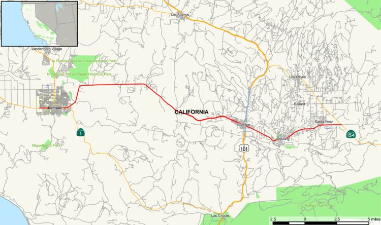
State Route 246 (SR 246) is a state highway in the U.S. state of California. It runs from Lompoc east to Santa Ynez, cutting through the Santa Barbara Wine Country.
Contents
Map of CA-246, California, USA
Route description
Most of the road is two lanes wide, with the exception of the route through the cities of Lompoc and Buellton. This is the primary route from U.S. Route 101 to Solvang, one of the Santa Ynez Valley's biggest tourist attractions. It follows the Santa Ynez River for most of its length. The portion of the route through Solvang is called Mission Drive, while through Lompoc—where is co-signed with State Route 1—it is called Ocean Avenue. SR 246 was defined all the way to Surf, but in 1984, it was truncated to the western city limits of lompoc. SR 246 then leads northeast out of Lompoc along a relatively flat two-lane road until reaching Buellton, where it widens upon its intersection with US 101. It narrows once again to two lanes through Solvang and Santa Ynez before reaching its eastern terminus at the junction with State Route 154. This is the main alternate route from Northern Santa Barbara County to the South Coast, and it is a pleasant drive for those who want to avoid the heavy truck traffic on US 101. It is also notable for passing two of Santa Barbara County's three Spanish-era missions, Santa Inés (in Solvang) and La Purísima Concepción (near Lompoc).
History
In 1933, this was designated as a state highway, and was numbered as Route 149 in 1935. In 1963, it was part of State Route 154. In the 1964 state highway renumbering, it was renumbered to SR 246. SR 246 used to run all the way west to Surf, but this segment was relinquished to local control in 1984.
Major intersections
Except where prefixed with a letter, postmiles were measured on the road as it was in 1964, based on its original western terminus in Surf, and do not necessarily reflect current mileage. R reflects a realignment in the route since then, M indicates a second realignment, L refers an overlap due to a correction or change, and T indicates postmiles classified as temporary (for a full list of prefixes, see the list of postmile definitions). Segments that remain unconstructed or have been relinquished to local control may be omitted. The entire route is in Santa Barbara County.