
- land 6.97 sq mi (18 km) - summer (DST) CDT (UTC−5) Local time Monday 12:56 AM | - water 2.12 sq mi (5 km) Population 2,626 (2013) | |
 | ||
Weather 12°C, Wind S at 23 km/h, 75% Humidity Points of interest Fort Defiance, Magnolia Manor, Historic Tunnel Cario Ent | ||
Cairo (generally pronounced /ˈkɛroʊ/ CARE-o by natives, and /ˈkeɪroʊ/ KAY-ro by others) is the southernmost city in the U.S. state of Illinois, and is the county seat of Alexander County.
Contents
- Map of Cairo IL 62914 USA
- Beginnings
- Post war prosperity
- Lynchings
- Economic decline
- Racial tensions and further decline
- Current status
- Geography
- Climate
- 2010 census
- 2000 census
- Education
- Transportation
- Landmarks and points of interest
- Filmvideo
- Literature
- Music
- Sports
- References
Map of Cairo, IL 62914, USA
Cairo is located at the confluence of the Mississippi and Ohio Rivers. The rivers converge at Fort Defiance State Park, a Civil War fort that was built in 1862 by Union General Ulysses S. Grant. Cairo has the lowest elevation of any location in Illinois and is the only Illinois city surrounded by levees. It is in the area known as Little Egypt.
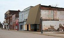
Several blocks in the town comprise the Cairo Historic District, listed on the National Register of Historic Places (NRHP). The Old Customs House is also on the NRHP. The city is part of the Cape Girardeau−Jackson, MO-IL Metropolitan Statistical Area. The population at the 2010 census was 2,831, a significant decline from its peak population of 15,203 in 1920.
The entire city was evacuated during the 2011 Mississippi River Floods, after the Ohio River rose higher than the 1937 flood levels, with the possibility of 15 feet of water inundating Cairo. The United States Army Corps of Engineers breached levees in the Mississippi flood zone below Cairo in Missouri to prevent more populous areas further upstream along both the Ohio and Mississippi rivers.
Beginnings
The first municipal charter for Cairo and for the Bank of Cairo were issued in 1818, bit without any settlement and without any depositors. A second and successful effort to establish a town was made by the Cairo City and Canal Company in 1836-37, with a large levee built to encircle the site. However, this effort collapsed in 1840, with few settlers remaining.
Charles Dickens visited Cairo in 1842, and was unimpressed. The city would serve as his prototype for the nightmare City of Eden in his novel Martin Chuzzlewit. In 1846, 10,000 acres in Cairo were purchased by the trustees of the Cairo City Property Trust, a group of investors who planned to make it the terminus of the projected Illinois Central Railroad, which finally arrived there in 1855. A new city charter was written in 1857, and Cairo flourished as trade with Chicago spurred development. By 1860, the population had exceeded 2,000.
In January 1862, during the Civil War, however, General Ulysses S. Grant occupied the city, and he and Admiral Andrew Hull Foote made the city their headquarters. Cairo would become an important supply base and training center for the rest of the war. Grant's military occupation caused much of the city's trade to be diverted to Chicago, and Cairo failed to regain it after the war. Instead, agriculture, lumber, and sawmills now dominated the economy.
Post-war prosperity
The strategic importance of Cairo's geographic location during the Civil War did spark prosperity. Several banks were founded during the war years, and the growth in banking and steamboat traffic continued after the war. Even before that, Cairo had been becoming an important steamboat port, and the city had been designated as a port of delivery by Act of Congress in 1854.
In 1869 construction began on the United States Custom House and Post Office, which was designed by Alfred B. Mullet, the Supervising Architect. The custom house was completed in 1872. It served as a custom house, post office, and United States Court. The U.S. District Court for the Southern District of Illinois met at the building until 1905. From 1905 to 1942, the building housed the U.S. District Court for the Eastern District of Illinois. The building also housed the U.S. Circuit Court for the Eastern District of Illinois from 1905 to 1912. The post office in the building was the third busiest in the United States at the height of Cairo's prosperity. One of only seven of Mullet's Victorian structures remaining in the nation, the building has been converted into a museum. It is listed on the National Register of Historic Places.
After the Civil War, the city became a hub for railroad shipping in the region, which added to its economy. By 1900 several railroad lines branched from Cairo. In addition to shipping and railroads, a major industry in Cairo was the operation of ferries. Into the late 19th century, nearly 250,000 railroad cars could be ferried across the river in as little as six months. Vehicles were also ferried, as there were no automobile bridges in the area in the early 20th century. The ferry industry created numerous jobs in Cairo to handle large amounts of cargo and numerous passengers through the city.
Wealthy merchants and shippers built numerous fine mansions in the 19th and early 20th century, including the Italianate Magnolia Manor, completed in 1872, and the Second Empire Riverlore Mansion, built by Capt. William P. Halliday in 1865. Across the street from the customs house, the Cairo Public Library was constructed in 1883 of Queen Anne-style architecture, finished with stained glass windows and ornate woodwork. The library was dedicated on July 19, 1884 as the A. B. Safford Memorial Library. Anna E. Safford paid for the construction of the Library and donated it to the city. These and other significant buildings are also listed on the National Register.
For protection from seasonal flooding, Cairo is completely enclosed by a series of levees and flood walls, due to its low elevation between the rivers. Several buildings, including the old custom house, were originally designed to be built to a higher street level, to be at the same height as the top of the levees. That plan was scrapped as the cost of fill to raise the streets and surrounding land to that height proved to be impractical. In 1914 a large flood gate was constructed by Stupp Brothers of St. Louis, Missouri. The flood gate is known as the "Big Subway Gate", and it was designed to seal the northern levee in Cairo by closing over U.S. Highway 51. The gate weighs 80 tons, is 60 feet wide, 24 feet high and five feet thick. With the addition of the gate, Cairo could become an island, completely sealed off from approaching flood waters.
Following the Great Mississippi Flood of 1927, the levee system around Cairo was strengthened. As part of this project, the Corps of Engineers established the Birds Point-New Madrid Floodway. The Ohio River flood of 1937 brought a record water level to Cairo that crested at 59.5 feet. To protect Cairo, Corps of Engineers closed the flood gate and blew a breach in the Bird's Point levee for the first time to relieve pressure on the Cairo flood wall. Following the flood, the concrete flood wall was raised to its current height. It is designed to protect the town from flood waters up to 64 feet.
In 1942 the federal government constructed a new U.S. Post Office and Court House in Cairo. Still growing, the city had a population approaching 15,000. The new federal court house, located at 1500 Washington, was designed by the architects Louis A. Simon and George Howe. The U.S. District Court for the Eastern District of Illinois moved into the new court house in 1942, from the old U.S. Custom House and Post Office. After the U.S. district court structure in Illinois was reorganized in 1978, the court house was used for the U.S. District Court for the Southern District of Illinois. The building remains in use by the federal courts and as the active post office for Cairo. The court house was built and is operated by the U.S. General Services Administration.
Lynchings
Cairo's turbulent history of race relations is often traced back to the lynching of black resident William James. In 1900, Cairo had a population of nearly 13,000. Of that total, approximately 5,000 residents were African-American. In 1900, this was an unusually high black population for a town of Cairo's size, and five percent of all black residents of the state of Illinois resided here. As a result of the large black population in a town with a traditionally southern white heritage, race relations were already strained by 1900. On the night of November 11, 1909 two men were lynched. The first man lynched was a black man named William James, who was allegedly responsible for the murder of Anna Pelly, a young white woman killed three days earlier. The second man lynched was a white man named Henry Salzner, who had allegedly murdered his wife in the previous August.
James was accused of killing Pelly by choking her to death in an alley with pieces of a flour sack on the dark and rainy evening of November 8, 1909. Pelly's body was discovered the next morning, and the evidence suggested that James and a possible accomplice had committed the crime. James was placed in police custody on Tuesday, where he remained until Wednesday evening. As word of the crime and evidence spread, the citizens of Cairo demanded an immediate trial for James, but the case was delayed by the court. With racial tension already at breaking point in Cairo, the townspeople grew quickly infuriated by the delay in a speedy trial. The threat of mob violence quickly developed as a result of the delay. On November 10, Will James was turned over to Sheriff Frank Davis, who quickly took James out of the city on an Illinois Central train to avoid any potential mob violence. An angry mob had formed in Cairo and seized another train and raced to catch up with James north of town. Sheriff Davis' attempt to save James from the mob proved futile as the mob was able to intercept James and the sheriff. The mob returned James to Cairo and led him to the intersection of Commercial Avenue and Eighth Street. The mob of approximately 10,000 attempted to hang James from large steel arches that spanned the intersection. When the noose was placed around the neck of James, he confessed "I killed her, but Alexander took the lead". Although he survived the hanging when the rope broke, the mob then shot James several times, killing him. Following the shooting, the mob dragged the body back to the scene of Anna Pelly's murder. His head was cut from his body and placed on a pole that was stuck into the ground, and then the body of James was burned.
Following the killing of Will James, the infuriated townspeople went out in search of the accomplice, Arthur Alexander. When the mob was unable to locate Alexander, they instead entered the court house and broke through the cell where Henry Salzner was being held. Salzner was hanged from a telegraph pole near the courthouse, and the crowd shot his body many times following the hanging. After hanging Salzner, the mob continued searching for Alexander long into the night. Police and sheriff deputies located Alexander before the mob, and they were able to get him escorted to the county jail by disguising him as a police officer. The mob pressed on still searching for Alexander, and the mayor and chief of police had to be guarded in their homes as the mob threatened them as well. The Governor of Illinois dispatched 11 companies of militia to Cairo. By the time the mob discovered Alexander was at the jail the following morning, soldiers had already arrived and were able to prevent any further violence.
Economic decline
The slow economic decline in Cairo can be traced back to the early 20th century. In 1889 the Illinois Central Railroad bridge was completed over the Ohio River, which brought about a decline in ferry business. The economic impact was not severe, as the railroad traffic still was directed through Cairo, and automobile traffic would also increase in the early 20th century. In 1905 a second bridge was constructed across the Mississippi River at Thebes, Illinois. The effects of the second bridge were felt much more, as rail traffic through Cairo was now reduced and ferry operations for the railroad were no longer necessary. As the steamboat industry was replaced with barges, there was no longer a significant reason for river traffic to stop in Cairo.
In 1929, the Cairo Mississippi River Bridge was completed, linking Missouri with Illinois to the south of Cairo. In 1937 the Cairo Ohio River Bridge was completed. With the two bridges completed, there was no longer a need for any kind of ferry industry at Cairo. Additionally, both bridges cross the rivers to the south of town, which allowed motorists to cross the southern tip of Illinois between Missouri and Kentucky by completely bypassing the city of Cairo. While the city was protected by its levees from destruction when the Ohio River rose to record heights during the 1937 flood, the city's decline continued.
Racial tensions and further decline
With river traffic and rail traffic drastically reduced, much of Cairo's employment prospects were gone with them. Between the 1930s and 1960s, the population in Cairo remained fairly steady; however, many of the employment opportunities were no longer available as the shipping, railroad, and ferry industries left the city. Population decline was already beginning; however, it was not the rapid decline that Cairo would later experience. In a city that had such a strong history of racial violence, racial tension was strained once again by the late 1960s as the United States was in the middle of the civil rights struggle. This tension further damaged the already declining economy of the city. On July 16, 1967, Robert Hunt, a 19-year-old black soldier home on leave, was found hanged in the Cairo police station. Police reported that Hunt had hanged himself with his T-shirt, but many members of the black community of Cairo accused the police of murder.
The death of Robert Hunt sparked aggressive protests in Cairo's black community, and on July 17, 1967, a large portion of the black population in Cairo began rioting. The black rioting that erupted in 1967 was not confined to Cairo; it was part of a larger pattern of more than 40 racially motivated riots that occurred across major cities in the United States in the summer of 1967. During the night of rioting on July 17, three stores and a warehouse in Cairo were burned to the ground, and windows were broken out of numerous other buildings. The national guard unit at Cairo was activated to respond to the violence. On July 20, 1967, one of the leaders of the violence in Cairo warned white city officials, "Cairo will look like Rome burning down" if city leaders did not meet the demands of the black groups in Cairo by Sunday, July 23, 1967. The spokesman represented approximately one hundred black residents of the Pyramid Court housing project, and the group demanded new job opportunities, organized recreation programs, and an end to alleged police brutality. Cairo Mayor Lee Stenzel and other city leaders met with federal and state representatives to ensure that a plan was developed to satisfy the demands by the deadline in an effort to head off any additional rioting.
In response to the rioting of July 1967, the white community in Cairo formed a citizens protection group that was deputized by the sheriff. The protection group became known as the "White Hats", because many of its 600 members began wearing white construction hats to show their membership while patrolling the streets to maintain order. In the following two years, accusations of White Hat bullying incidents in the black community began to increase. In early 1969, a few activists of the civil rights struggle formed the Cairo United Front civil rights organization by bringing together the local NAACP, a cooperative association, and a couple of black street gangs. The Cairo United Front was formed to organize the efforts of the black population in Cairo to counter the White Hats. The United Front began its work by formally accusing the White Hats of intimidating the black community, and presented a list of seven demands to the City of Cairo. The seven demands included appointment of a black police chief, appointment of a black assistant fire chief, and an equal black-white ratio in all city jobs.
Racial violence in Cairo reached a peak during summer 1969 as the Cairo United Front began leading protests and demonstrations to end segregation and draw attention to its seven demands. The protests led to a rash of violence that was stopped only when Illinois Governor Richard Ogilvie deployed National Guardsmen to restore the peace. In summer 1969, the Cairo United Front also began a decade-long boycott of white-owned businesses, which encompassed virtually all the businesses in the town. In December 1969, violence escalated again as several more businesses were burned on Saturday, December 6. Early that morning, residents of the Pyramid Courts housing project opened fire on three firemen and the Chief of Police while they were responding to one of the intense fires. During the shootout, the Chief of Police and one of the firemen were shot by a high-powered rifle. 13 people were eventually arrested during the conflict. The Cairo Chief of Police resigned the next month stating that Cairo lacked both the legal and physical means to deal with the "guerrilla warfare tactics" that had left the town in a state of turmoil for over two years. The picketing continued throughout 1970, and in December, a new city ordinance was enacted that banned picketing within 20 feet of a business. Another large violent clash erupted as a result of the new city ordinance. Following the violence, the United Front called for another large rally and resumed picketing at white-owned businesses despite the new ordinance. The picketing turned violent after police heard shots fired and then moved on the crowd.
In 1978, Cairo received yet another blow to its economy when the Interstate 57 bridge across the Mississippi River was opened. With the interstate now bypassing the city, the remaining hospitality industry in Cairo was crippled. Cairo's hospital also closed in December 1986, due to high debt and dwindling patients.
Current status
With the decline in river trade, as has been the case in many other cities on the Mississippi, Cairo has experienced a marked decline in its economy and population. Its highest population was 15,203 in 1920; in 2010 it had 2,831 residents. The community and region are working to stop abandonment of the city, restore its architectural landmarks, and develop heritage tourism focusing on its history and relationship to the Mississippi and Ohio Rivers, to bring new opportunities to the community.
The city faces many significant socio-economic challenges for the remaining population, including poverty, crime, issues in education, unemployment and rebuilding its tax base. A community clinic offers medical and dental care, and also several mental health services. Local media include WKRO radio, 1490 AM and the Cairo Citizen weekly newspaper.
Geography
Cairo is located at the confluence of the Mississippi with the Ohio River, near Mounds, Illinois. The elevation above sea level is 315 feet (96 m). The lowest point in the state of Illinois is located on the Mississippi River in Cairo.
According to the 2010 census, Cairo has a total area of 9.086 square miles (23.53 km2), of which 6.97 square miles (18.05 km2) (or 76.71%) is land and 2.116 square miles (5.48 km2) (or 23.29%) is water.
Climate
The city of Cairo has a humid subtropical climate (Köppen Cfa) and has many characteristics of a city in the Upland South. Summers are hot and humid, with a daily average in July of 78.9 °F (26.1 °C) and temperatures reaching 90 °F (32 °C) on an average of 40 days annually. Winters are generally cool with mild periods. Though extended periods of cold can occur, Cairo's winter is typically mild by Illinois standards, as the January daily average is 34.0 °F (1.1 °C). Precipitation is present and spread relatively evenly throughout the year. On average, Cairo's low elevation and proximity to the Mississippi and Ohio rivers prevent strong winter lows and plunging temperatures; however, during the summer months those similar features retain heat and humidity, creating muggy conditions.
2010 census
As of the census of 2010, there were 2,831 people, 1,268 households, and 677 families residing in the city. There were 1,599 housing units. The racial makeup of the city was 29.2% White, 71.5% Black or African American, 0.5% Native American, 0.6% Asian, less than 0.1% Pacific Islander, 0.3% from other races, and 2.0% from two or more races. Hispanic or Latino of any race were 0.4% of the population.
There were 1,268 households, of which 26.7% had children under the age of 18 living with them, 21.2% were married couples living together, 28.5% had a female householder with no husband present, and 46.6% were non-families. 43.5% of all households were made up of individuals and 15.2% had someone living alone who was 65 years of age or older. The average household size was 2.15 and the average family size was 3.00.
The distribution of the population by age was 31.6% 19 or under, 6.3% from 20 to 24, 19.2% from 25 to 44, 26.2% from 45 to 64, and 16.6% 65 or older. The median age was 36.9 years.
The median income for a household in the city was $16,682, and the median income for a family was $31,507. Males working full-time, year-round had a median income of $37,750 versus $21,917 for females. The per capita income for the city was $12,461. About 33.0% of families and 44.2% of the population were living below the poverty line, including 71.7% of those under the age of 18 and 20.6% of those ages 65 and older.
2000 census
As of the census of 2000, there were 3,632 people, 1,561 households, and 900 families residing in the city. The population density was 515.1 people per square mile (198.9/km²). There were 1,885 housing units at an average density of 103.2 per km² (267.3 per sq mi). The racial makeup of the city was 35.93% White, 61.70% Black or African American, 0.08% Native American, 0.72% Asian, 0.03% Pacific Islander, 0.36% from other races, and 1.18% from two or more races. Hispanic or Latino of any race were 0.74% of the population.
There were 1,561 households out of which 30.4% had children under the age of 18 living with them, 29.3% were married couples living together, 25.2% had a female householder with no husband present, and 42.3% were non-families. 39.7% of all households were made up of individuals and 17.6% had someone living alone who was 65 years of age or older. The average household size was 2.26 and the average family size was 3.08.
The distribution of the population by age was 30.4% under 18, 8.1% from 18 to 24, 22.0% from 25 to 44, 21.6% from 45 to 64, and 17.9% who were 65 or older. The median age is 36 years. For every 100 females there were 79.5 males. For every 100 females age 18 and over, there were 70.2 males.
The median income for a household in the city was $21,607, and the median income for a family was $28,242. Males had a median income of $28,798 versus $18,125 for females. The per capita income for the city was $16,220. About 27.1% of families and 33.5% of the population were living below the poverty line, including 47.0% of those under the age of 18 and 20.9% of those ages 65 and older.
Education
The city is served by Cairo Unified School District 1. Based on census estimates, the Cairo school district has the highest percentage in Illinois of children in poverty, 60.6%, which ranks fifteenth highest in the United States.
The district has one elementary school, Emerson Elementary School. Middle and high school students attend Cairo Junior/Senior High School. Bennett Elementary School closed in 2010.
Transportation
Amtrak service to Cairo ended on October 25, 1987 when the City of New Orleans began bypassing the city. The nearest stops are Carbondale, Illinois (53 miles (85 km)) and Fulton, Kentucky (43 miles (69 km)).
Major highways include:
Cairo's location on a spit of land that lies between the Mississippi and Ohio rivers made multiplexing US 60 and 62 briefly through Illinois more practical than directly connecting Missouri and Kentucky.
The closest airports with regular service are Barkley Regional Airport in Paducah, with flights to Chicago-O'Hare, and Cape Girardeau Regional Airport. The airports are approximately 29 miles and 39 miles away, respectively.
Landmarks and points of interest
Magnolia Manor is a postbellum manor, built by the Cairo businessman Charles A. Galigher in 1869. It is a 14-room red brick house which features double walls intended to keep out the city's famous dampness with their ten-inch airspaces. Inside the home are many original, 19th-century furnishings. It has been listed on the National Register of Historic Places since December 17, 1969. The house is operated as a Victorian period historic house museum by the Cairo Historical Association.
Other points of interest include: