
Population 94,766 (2011) Province Québec | Area 247,627 km² Local time Tuesday 6:30 PM | |
 | ||
Website www.cotenord.gouv.qc.ca | ||
Co te nord qu bec 4k
Côte-Nord ([kot nɔʁ], French for "North Shore", area 247,633.94 km²) is the second largest administrative region by land area in Quebec, Canada, after Nord-du-Québec. It covers much of the northern shore of the Saint Lawrence River estuary and the Gulf of Saint Lawrence past Tadoussac.
Contents
- Co te nord qu bec 4k
- Map of CC3B4te Nord QC Canada
- Population
- Geography and economy
- Subdivisions
- Major communities
- Exploration
- References
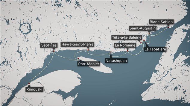
Map of C%C3%B4te-Nord, QC, Canada
While most of the region is in the same time zone as the rest of Quebec, the far eastern portion east of the 63rd meridian, including half of Anticosti Island, is officially in the Atlantic Time Zone.
Population
At the 2011 census, the population amounted to 94,766, slightly more than 1% of the province's population, spread across 33 municipalities, various Indian reserves, and a Naskapi reserved land. The towns of Baie-Comeau and Sept-Îles combined amount to a little more than half of the population of the region.
Geography and economy
Côte-Nord was created as an administrative region in 1966. Important landmarks of Côte-Nord include Anticosti Island, the Mingan Archipelago, and the Manicouagan Reservoir.
A territorial dispute between Quebec and Newfoundland and Labrador concerning the border between Côte-Nord and Labrador was set on 2 March 1927 by the Judicial Committee of the Privy Council. The boundary was entrenched in the Canadian constitution upon Newfoundland joining confederation in 1949. While this border has not been formally accepted by the Quebec government, the Henri Dorion Commission (Commission d'étude sur l'intégrité du territoire du Québec) concluded in the early 1970s that Quebec no longer has a legal claim to Labrador.
The region's economy is based on mining (mostly iron), lumbering, aluminum production, and tourism. Côte-Nord's fourteen hydroelectric dams, notably the Manicouagan-Outardes complex, supply Hydro-Québec with over 10,500 megawatts of power.
Subdivisions
Regional county municipalities
Indian reserves
Naskapi reserved territory
Major communities
Exploration
The Côte-Nord region was gradually explored by French colonists during the centuries with the help of natives. However it is worth noting the contribution of Henry de Puyjalon (1841-1905), a pioneer in ecology that as devoted his life to the exploration of this region.