
Area rank 70 in Norway Area 1,312 km² Local time Thursday 2:10 PM | County Aust-Agder Administrative centre Bygland Demonym(s) Byglending Population 1,223 (2010) | |
 | ||
Weather 1°C, Wind SE at 6 km/h, 83% Humidity Points of interest Reiårsfossen, Elgtun, Sandstrand, Gysand | ||
Bygland is a municipality in the county of Aust-Agder, Norway. The municipal centre is the village of Bygland. Other villages in the municipality include Byglandsfjord, Lauvdal, and Åraksbø. The municipality is bordered on the north by Valle, in the east by Fyresdal (Telemark) and Åmli (Aust-Agder), in the south by Froland and Evje og Hornnes, and in the west by Åseral (Vest-Agder), Kvinesdal (Vest-Agder) and Sirdal (Vest-Agder).
Contents
Map of Bygland, Norway
General information
Bygland was established as a municipality on 1 January 1838 (see formannskapsdistrikt). Since that time, the municipal boundaries have not changed.
Name
The municipality (originally the parish) is named after the old Bygland farm (Old Norse: Byggland), since the first church was built there. The first element is bygg which means "barley" and the last element is land which means "land" or "farm".
Coat-of-arms
The coat-of-arms is from modern times. They were granted on 15 November 1991. The arms show a European lynx (Lynx lynx), which symbolises the wild and rich nature and forests in the municipality.
Geography
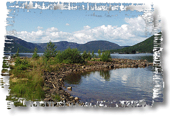
Bygland lies in the middle of Setesdal, a valley and a traditional district in Aust-Agder that included the municipalities of Bykle, Valle, Bygland, Iveland, and Evje og Hornnes. The Otra river flows from the glacially scoured Hardanger plateau (Norwegian: Hardangervidda) in Telemark to the north, through the valley of Setesdal (and through Bygland), into the sea near Kristiansand. The lake Gyvatn is located along the border with Evje og Hornnes and Åseral.
Bygland is Aust-Agder's second largest municipality in area. The majority of the municipality lies about 700 metres (2,300 ft) above sea level. The municipality stretches from the small town Byglandsfjord in the south to the farms at Langeid in the north. Lake Byglandsfjorden is 40 kilometres (25 mi) long and lies on the river Otra. Other lakes include the Åraksfjorden, Gyvatn, Hovatn, Kvifjorden, Longerakvatnet, Straumsfjorden, and Topsæ.
History
The Setesdal Line was a narrow gauge steam railway which went between Vennesla and Byglandsfjord in Bygland. It was built in 1896. The Setesdal Line's operation was terminated in 1962 and the track was removed between Byglandsfjord and Beihølen.
Other transport up the Setesdal valley was provided by the steamships Bjoren and Dølen. First placed in operation in 1866, the Bjoren is still in operation as a tourist attraction on lake Byglandsfjorden.