Trisha Shetty (Editor)

Butterfield Overland Mail in Texas

Updated on
Edit
Like
Comment
Share on FacebookTweet on TwitterShare on LinkedInShare on Reddit
Type
  
historic trail

Designated
  
August 27, 2014

Type
  
U.S. historic district

Reference no.
  
14000524

Butterfield Overland Mail in Texas

Location
  
New Mexico Territory near Anthony - Indian Territory near Sherman

Location
  
Guadalupe Mountains National Park

In Texas, the Butterfield Overland Mail service created by Congress on March 3, 1857, operated until March 30, 1861. The route that was operated extended from San Francisco, California to Los Angeles, then across the Colorado Desert to Fort Yuma, then across New Mexico Territory via, Tucson and Mesilla, New Mexico to Franklin, Texas, midpoint on the route. The route through Texas followed first the northern route to the Pecos River and downstream to Horse Head Crossing. The route in West Texas was changed in 1859, in order to secure a better water supply on the route and to provide mail service to a more settled area, the stages between Franklin and the Pecos River followed the San Antonio-El Paso Road to Camp Stockton and then turned east to Horsehead Crossing. From Horsehead Crossing the route crossed Texas to the Red River and into Indian Territory. In 1860 the route was changed to another route from Jacksboro to Sherman via Decatur due to the building of a new toll bridge at Bridgeport, that avoided delays crossing the West Fork of the Trinity River when it was flooded. From Colberts Ferry the route went on to Fort Smith, then up across Arkansas and southwest Missouri to Tipton with the final leg by train to St. Louis. The Texas mail route was so long that the route there, like that in California, was divided into two divisions each under a superintendent.

Contents

5th Division Route

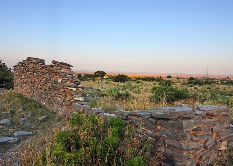
At first the 5th Division route left Franklin to run due east thirty miles to Hueco Tanks, thirty six miles to Cornudas de Los Alamos then east northeast fifty-six miles to Pinery Station. Subsequently stations were added between Hueco Tanks and Cornudas de Los Alamos at Ojos de los Alamos, and at Crow Springs between Cornudas de Los Alamos and Pinery. From Pinery, the route then ran twenty-four miles east to Delaware Springs Station, then forty miles down Delaware Creek nearly to its junction with the Pecos River, and across Pope's Crossing to Pope's Camp. It then ran sixty five miles down the east bank of the Pecos, to Emigrant Crossing Station and onward fifty-five miles to Horsehead Crossing. Sections of this route, including Pinery Station, are preserved as part of Guadalupe Mountains National Park, and have been listed on the National Register of Historic Places.

In August 1859, the route in West Texas was changed in order to secure a better water supply on the route and to provide mail service to a more settled area, the stages between Franklin and the Pecos River followed the San Antonio-El Paso Road down the Rio Grande, passing through Ysleta 14 miles from Franklin, Socorro, San Elizario, Birchville Station, then 33 miles to Fort Quitman. Moving eastward away from the river at Fort Quitman, the route traveled 31 miles to Eagle Spring, 19 miles to Lobo and the Van Horns Wells, then a waterless 33 miles to Deadman's Hole, 18 miles to Barrel Springs, another 18 miles to Fort Davis. From Fort Davis Station the route proceeded down through Limpia Canyon to Limpia Station, Barrilla Springs, then 34 miles to Leon Springs and on to Camp Stockton. 45 miles east of Camp Stockton the route reached Horsehead Crossing where a ferry carried the coaches across the Pecos River to Horsehead Crossing Station.

From Horsehead Crossing the trail ran seventy waterless miles east northeast across the Llano Estacado to the headwaters of the Middle Concho River, then northward, about thirty miles through the vicinity of modern Carlsbad, to a camp or station;, then twenty-two miles to Grape Creek Station near the south line of present Coke County; to Fort Chadbourne in what is now Coke County.

6th Division Route

The 6th Division route ran from Fort Chadbourne, twelve miles to the north across Valley Creek to Station #1 then sixteen miles to Mountain Pass Station, then thirty miles, past the route of the Texas and Pacific Railway, a mile west of the site of present Tye, to Fort Phantom Hill, then twelve miles more to Smith's Station, twenty six miles to Clear Fork station, thirteen miles to Franz's Station and then twenty-two miles to Fort Belknap. From Fort Belknap the line turned eastward sixteen miles to Murphy's Station (near present Graham, Texas), then nineteen miles to Jacksboro, Texas, sixteen miles to Earhart's Station, twenty-four miles to Davidson's Station, then seventeen miles to Gainesville, Texas, fifteen miles to Diamond's station (one mile west of the site of present Whitesboro), fifteen miles to Sherman and across the Red River at Colbert's Ferry, eight miles below Preston, Texas to Indian Territory.

4th Division

  • Cottonwoods Station - Located, 25 miles from Fort Filmore on the Rio Grande in Texas.
  • 5th Division

  • Franklin Station - Located in Texas, 22 miles from Cottonwoods Station. - Midway point of the route.
  • Captain Pope's New Road from Franklin to Horse Head Crossing Station (1st route used, until August 1, 1859 when route was moved to the Lower Road.)

  • Hueco Tanks Station - Located 30 miles from Frankln.
  • Ojos de los Alamos Station - A later station, located 20 miles east of Hueco Tanks Station in New Mexico.
  • Cornudas de Los Alamos Station - Located 36 miles from Hueco Tanks in New Mexico.
  • Crow Springs Station - A relay station east of Cornudas Station midway to Pinery Station, only used in 1858
  • Pinery Station - Located 56 miles from Cornudas, just east of Guadelupe Pass no water on the route except at station.
  • Independence Spring - Spring located 5 miles from Pinery Station.
  • Delaware Springs Station - Located 24 miles from Pinery Station.
  • Pope's Camp Station - Located 40 miles from Delaware Springs.
  • Emigrant Crossing Station - Located 65 miles from Pope's Camp, 55 miles to Horse Head Crossing Station.
  • Lower Road, from Franklin to Horse Head Crossing Station (used from August 1, 1859)

  • Ysleta - Located 14 miles from Franklin.
  • Socorro - Located 3 miles from Ysleta.
  • San Elizario - Located 914 miles from Socorro.
  • Birchville or Smith's Ranch Station - Located 2412 miles from San Elizario.
  • Fort Quitman - Located 33 miles from Birchville Station.
  • Eagle Spring - Located 31 miles from Fort Quitman.
  • Van Horns Wells Station - Located 19 miles from Eagle Spring.
  • Deadman's Hole Spring or El Muerto Spring - Located 33 miles from Van Horns Wells Station, northeast of Valentine, Texas.
  • Barrel Springs Station - Located 18 miles southeast of Deadman's Hole.
  • Fort Davis Station - Located near Fort Davis 18 miles from Barrel Springs.
  • Limpia Station - Located 18 miles from Fort Davis in Limpia Canyon.
  • Barela Springs Station - Located 10 miles from Limpia Station.
  • Hackberry Holes Station - A later station, located 15 miles from Barela Springs, 22 miles from Leon Springs.
  • Leon Springs Station - Located 34 miles from Barela Springs.
  • Camp Stockton - Located 812 miles from Leon Springs, 45 miles from Horsehead Crossing Station
  • Main 5th Division Route

  • Horse Head Crossing Station - On the Pecos River, located 55 miles from Emigrant Crossing Station on the northern route and 45 miles from Camp Stockton on the Lower Road. A ferry was added to carry coaches across the Pecos River from August 1, 1859.
  • Mustang Waterholes Station - Later station between Horse Head Crossing and Head of Concho, nearest Horse Head Crossing.
  • Llano Estacado Station - Later station midway between Horse Head Crossing and Head of Concho.
  • Camp Johnston Station - Later station between Horse Head Crossing and Head of Concho, nearest Head of Concho.
  • Head of Concho Station - Located 70 miles from Horsehead Crossing, no water on the route except at station.
  • Grape Creek Station - Located 22 miles from Head of Concho.
  • Colorado River Station - Later station between Grape Creek Station and Fort Chadbourne.
  • Fort Chadbourne - Located 30 miles from Grape Creek Station.
  • 6th Division

  • Valley Creek Station - Located 12 miles north east of Fort Chadbourne, on the east bank of Valley Creek, about 1 mile northwest of Shep.
  • Mountain Pass Station - Located 16 miles from Valley Creek Station, about 11 miles due south of Merkel.
  • Phantom Hill Station - Located 30 miles from Mountain Pass Station, about 10 miles north of present-day Abilene.
  • Smith's Station - Located 12 miles from Phantom Hill Station, on the east bank of Chimney Creek.
  • Clear Fork Station - Located 26 miles from Smith's Station, on the east bank of the Clear Fork of the Brazos River, a short distance above its confluence with Lambshead Creek, north of the later site of Fort Griffin.
  • Francis' Station or Franz's Station - Located 13 miles from Clear Fork Station, about 3 miles north of Murray.
  • Fort Belknap Station - Located 22 miles from Francis' Station.
  • Murphey's Station - Located 16 miles from Fort Belknap, about 412 miles south of Loving.
  • Jacksboro Station - Located 19 miles from Murphey's Station.
  • Earhart's Station - Located 16 miles from Jackboro Station, west of Cundiff, Texas on the west bank of Big Creek to 1860.
  • Bridgeport - 1860 - March 1861 station and toll bridge on alternate route between Sherman and Jacksboro
  • Conolly's Station - Located 16 miles from Earhart's Station, 4 miles northwest of Alvord, Texas to 1860.
  • White Rock Station - 1860 - Feb. 1861 station on alternate route between Sherman and Jacksboro
  • Davidsen's Station - Located 24 miles from Conolly's Station, 4 miles west of Era, Texas to 1860.
  • Decatur - 1860-61 station on alternate route between Sherman and Jacksboro.
  • Gainesville Station - Located 17 miles from Davidsen's Station to March 1861.
  • Denton - March 1861 station on alternate route between Sherman and Jacksboro.
  • Diamond's Station - Located 15 miles from Gainesville Station to March 1861.
  • Pilot Point - March 1861 station on alternate route between Sherman and Jacksboro.
  • Sherman Station - Located 15 miles from Diamond's Station.
  • Colbert's Ferry - Located 1312 miles from Sherman Station, ferry crossing of the Red River to Indian Territory.
  • References

    Butterfield Overland Mail in Texas Wikipedia