
Length 10 km | ||
 | ||
River mouth Los Angeles River, California Similar Compton Creek, Tujunga Wash, Bell Creek, Arroyo Calabasas, Rio Hondo | ||
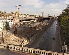
Burbank Western Channel (also known as Burbank Western Wash) is a 6.3-mile-long (10.1 km) tributary of the Los Angeles River in the eastern San Fernando Valley of Los Angeles County, California.
Contents
Map of Burbank Western Channel, California, USA
The stream begins at the confluence of Hansen Heights Channel and La Tuna Canyon Lateral in Sun Valley. It runs adjacent to Interstate 5 for most of its length and is entirely encased in a concrete flood control channel. The stream travels southeast through downtown Burbank, the Riverside Rancho area of Glendale, ultimately joining the Los Angeles River by the edge of the Los Angeles Equestrian Center.
In 1991, the city of Burbank was sued by the EPA for allowing companies to exceed discharge limits into the channel. Leading pollutants in the stream include algae, ammonia, cadmium, odors, unnatural scum/foam, and trash.
Under the American Recovery and Reinvestment Act of 2009, the U.S. Army Corps of Engineers has planned to allocate $700,000 to repair the channel wall which is "currently in danger of failing."
In October 2009, Burbank reached an agreement with the state on the 12 mile San Fernando Bikeway, a new bicycle path along San Fernando Boulevard from Sylmar to Burbank. This would include a portion next to the channel that connects to the Downtown Burbank Metrolink Station.
Crossings and tributariesEdit
From mouth to source (year built in parentheses):