
Country India Time zone IST (UTC+05:30) | Demonym(s) Bundelkhandi | |
 | ||
Separated states Similar Malwa, Bagelkhand, Purvanchal | ||
Bundeli rai dance bundelkhand up india
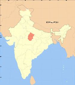
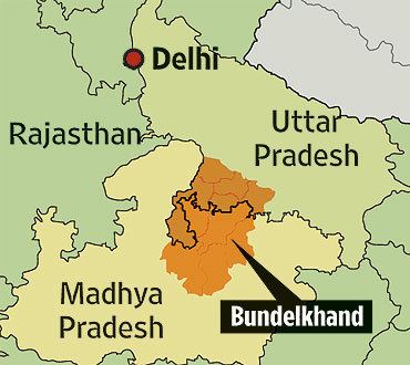
Bundelkhand is a region and also a mountain range in central India. The hilly region is now divided between the states of Uttar Pradesh and Madhya Pradesh, with the larger portion lying in M.P.
Contents
- Bundeli rai dance bundelkhand up india
- Etymology
- Geography
- Ecology
- Medieval Period Maratha Rule
- British rule 18021947
- Independent India 1947present
- Proposed Bundelkhand state
- Culture
- Folk dances
- Radio
- Prominent Bundelkhandis
- References
The Khangar ruled areas of present-day Bundelkhand after the fall of the Chandelas in 1182 A.D. and until the mid-14th century. Their seat of power was at Garh Kundar, a fort built by Khub Singh Khangar. During the Khangar rule, Bundelkhand was known as Jujhauti, implying the land of warriors. The name of the region derives from the Bundela Rajputs, who succeeded the Chandel Rajputs as rulers of the region in the 16th century.
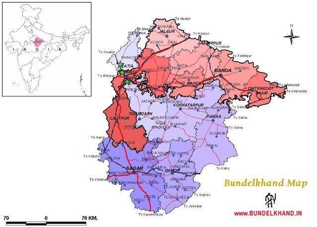
The major towns of Bundelkhand are Gwalior, Chirgaon, Datia, Dabra, Mauranipur, Narsinghpur, Panna, Jhansi, Banda, Chitrakoot, Datia, Tikamgarh, Rath, Lalitpur, Sagar, Damoh, Orai, Hamirpur, Mahoba, Banda, Ashoknagar, and Chhatarpur.
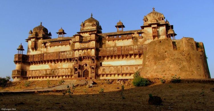
Among the well-known places of Bundelkhand is Khajuraho, which has numerous 10th-century sculptures devoted to fine living and eroticism. The mines of Panna have been the source of magnificent diamonds; a very large one dug from the last active mine was kept for a time in the fort of Kalinjar
Etymology
Bundelkhand means "Bundela domain". The region was earlier known as Jejabhukti or Jejakabhukti ("Jeja's province"). According to the inscriptions of the Chandela dynasty, this name derived from Jeja, the nickname of their ruler Jayashakti. However, it is possible that this name derives from an even earlier name of the region: "Jajhauti" or "Jijhoti". After the Bundelas replaced the Chandelas around 14th century, the region came to be known as Bundelkhand after them.
Geography
Bundelkhand lies between the Indo-Gangetic Plain to the north and the Vindhya Range to the south. It is a gently sloping upland, distinguished by barren hilly terrain with sparse vegetation, although it was historically forested. The plains of Bundelkhand are intersected by three mountain ranges, the Vindhya, Fauna and Bander chains, the highest elevation not exceeding 600 meters above sea-level. Beyond these ranges the country is further diversified by isolated hills rising abruptly from a common level, and presenting from their steep and nearly inaccessible scarps eligible sites for forts and strongholds of local kings. The general slope of the country is towards the northeast, as indicated by the course of the rivers which traverse or bound the territory, and finally discharge themselves into the Yamuna River.
The principal rivers are the Sindh, Betwa, Shahzad River, Ken, Bagahin, Tons, Pahuj, Dhasan and Chambal. The Kali Sindh, rising in Malwa, marks the western frontier of Bundelkhand. Parallel to this river, but further east, is the course of the Betwa. Still farther to the east flows the Ken, followed in succession by the Bagahin and Tons. The Yamuna and the Ken are the only two navigable rivers. Notwithstanding the large number of streams, the depression of their channels and height of their banks render them for the most part unsuitable for the purposes of irrigation, which is conducted by means of ponds and tanks. These artificial lakes are usually formed by throwing embankments across the lower extremities of valleys, and thus arresting and impounding the waters flowing through them.
Ecology
Drought: - since 2007 Bundelkhand region has been facing severe drought problems. Normal rainy days in Bundelkhand is 52 days (metrological department of India) but last six years its restricted 24 days. Timing of Monsoon usually in this area is second week of June but, Year 2008 this season saw rains, but in the second week of June alone the region received around 32 percent of its total rainfall. Farmers were not prepared for sowing. Then till July 2008, most of the Bundelkhand region received around 55 percent of its total average rainfall. This change caused floods and widespread losses in livestock and top soil. In Bundelkhand region, average level of rainfall is 800–900 mm. (Ramesh et al. 2002), But last six years Bundelkhand received only 400–450 mm. agriculture production also decreases in this areas in 2000 this region used to contribute 15 percent of the state’s total food grain production, which has now come down to seven percent. A once food secure zone has now become a symbol of insecurity and migration due to climate change. In this area various livelihoods such as fishing, vegetable production and traditional betel leaf farming are facing one of the worst crises ever.
Medieval Period & Maratha Rule
The Chandela Rajput clan ruled Bundelkhand from the 10th to the 16th centuries. In the early 10th century they were feudatories of the Pratiharas of Kannauj, and ruled from the fortress-city of Kalinjar. A dynastic struggle among the Pratiharas from 912 to 914 allowed the Chandelas and other feudatories to assert their independence. The Chandelas captured the strategic fortress of Gwalior c. 950. Dhanga (c. 950–1008) left many inscriptions, and endowed a large number of Jain and Hindu temples. Dhanga's grandson Vidyadhara (1017–29) expanded the Chandela kingdom to its greatest extent, extending the Chandela dominions to the Chambal river in the northwest and south to the Narmada River. The Afghan king Mahmud of Ghazni attacked the Chandela dominions during Vidydhara's reign, but were repulsed by powerful Chandela Rajputs. The Chandelas built the famous temple-city of Khajuraho between the mid-10th and mid-11th centuries. During the Chandela period, Bundelkhand was home to a flourishing Jain community and numerous Jain temples were built in that period.
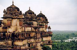
In the 12th century, the Rajput Chauhan rulers of Ajmer challenged the Chandelas. The Muslim conquests of the early 13th century reduced the Chandela domains, although they survived until the 16th century as minor chieftains. Bundela Rajputs grew to prominence starting in the 16th century. Orchha was founded in the 16th century by the Bundela chief Rudra Pratap Singh, who became the first raja of Orchha. In 1545 Sher Shah Suri, was killed while attempting to capture Kalinjar from the local Chandela king.
The region came under nominal Mughal rule from the 16th to 18th centuries, although the hilly, forested terrain of the sparsely populated region made it difficult to control. Akbar's governors at Kalpi maintained a nominal authority over the surrounding district, and the Bundela chiefs were in a state of chronic revolt, which culminated in the war of independence under Chhatrasal. On the outbreak of his rebellion in 1671 he occupied a large province to the south of the Yamuna. Setting out from this base, and assisted by the Marathas, he conquered the whole of Bundelkhand. On his death in 1732 he bequathed one-third of his dominions, including Jalaun and Jhansi, to his Maratha allies, who before long succeeded in controlling the whole of Bundelkhand, with the local rulers as tributaries to the Marathas. Under Maratha rule the country was a prey to constant anarchy and strife. By the end of the 18th century, the Bundelas had freed themselves to some extent from Maratha power. A grandson of the Maratha Peshwa, sought to restore Maratha control of Bundelkhand from his base at Banda. Ali Bahadur warred with the Bundelas from 1790 until 1802, when he died while attempting to capture Kalinjar.
British rule, 1802–1947
The Marathas ceded parts of Bundelkhand, which were later called later British Bundelkhand, to the British in the 1802 Treaty of Bassein. After 1802, many of the local rulers were granted sanads (leases) by the British, which entitled them to the lands they controlled at the death of Ali Bahadur, in return for the rulers signing a written bond of allegiance (ikrarnama) to the British. A political officer attached to the British forces in Bundelkhand supervised British relations with the sanad states. In 1806 British protection was promised to the Maratha ruler of Jhansi, and in 1817 the British recognised his hereditary rights to Jhansi state. In 1818 the Peshwa in Pune ceded all his rights over Bundelkhand to the British at the conclusion of the Third Anglo-Maratha War.
The sanad states were organised into the Bundelkhand Agency in 1811, when a political agent to the Governor-General of India was appointed and headquartered at Banda . In 1818 the headquarters were moved to Kalpi, in 1824 to Hamirpur, and in 1832 back to Banda. The political agent was placed under the authority of the Lieutenant-Governor of the North-Western Provinces, headquartered in Agra, in 1835. In 1849 authority over the Bundelkhand Agency was placed briefly under the Commissioner for the Saugor and Nerbudda Territories, who appointed a political assistant based at Jhansi. Shortly thereafter, authority over Bundelkhand was placed under the Resident at Gwalior, and the headquarters of the political assistant was moved to Nowgong, which remained until 1947. In 1853 the Raja of Jhansi died childless, and his territory was annexed to British Bundelkhand. The Jhansi state and the Jalaun and Chanderi districts were then formed into a superintendency. In 1854 Bundelkhand Agency was placed under the authority of the newly created Central India Agency, headquartered at Indore.
The widow of the Raja of Jhansi, Rani Lakshmi Bai, protested against the annexation because her adopted son was not recognised as the heir to his adoptive father, and because the slaughter of cattle was permitted in the Jhansi territory. The Revolt of 1857 found Jhansi ripe for rebellion. In June a few men of the 12th native infantry seized the fort containing the treasure and magazine, and massacred the European officers of the garrison. The Rani put herself at the head of the rebels, and they captured several of the neighbouring British districts and princely states allied to the British. She died bravely in battle in Gwalior in 1858. It was not till November 1858 that Jhansi was brought under British control.
After the revolt, Jhansi was given to the Maharaja of Gwalior, but came under British rule in 1886 when it was swapped for Gwalior fort. In 1865 the political assistant was replaced with a political agent. The eastern portion of the Agency was detached to form Bagelkhand Agency in 1871. The state of Khaniadhana was transferred to the authority of the Gwalior Resident in 1888, and in 1896 Baraundha, Jaso, and the Chaube Jagirs were transferred to Bagelkhand. In 1901 there were 9 states, 13 estates, and the pargana of Alampur belonging to Indore State, with a total area of 9,851 sq mi (25,510 km2) and a total population of 1,308,326 in 1901. The most important of the states were Orchha, Panna, Samthar, Charkhari, Chhatarpur, Datia, Bijawar and Ajaigarh State. Deforestation accelerated during British rule. The population of the agency decreased 13% between 1891 and 1901 due to the effects of famine. In 1931 Bagelkhand Agency, with the exception of the state of Rewa State, was merged into Bundelkhand Agency.
Independent India, 1947–present
After Indian independence in 1947, the princely states of Bundelkhand Agency were combined with those of the former Bagelkhand Agency to form the province of Vindhya Pradesh, which became an Indian state in 1950. On 1 November 1956, Vindhya Pradesh was merged into Madhya Pradesh.
Notorious dacoits like Pooran Sing alias Puja babba and Moorath Singh besides other robber gangs once ruled the area. Currently the area is economically and industrially one of the most backward areas in India. Lack of resources, poor communications, and infertile land are some of the reasons for underdevelopment in the region.
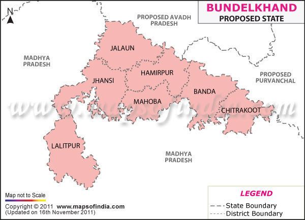
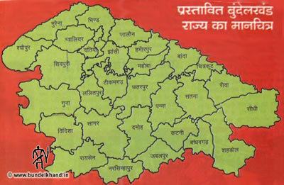
Proposed Bundelkhand state
Bundelkhand comprises parts of Uttar Pradesh and Madhya Pradesh. While Bahujan Samaj Party government under Mayawati had proposed in 2011 creation of Bundelkhand from seven districts of Uttar Pradesh, organizations such as Bundelkhand Mukti Morcha (BMM) want it to include six districts from Madhya Pradesh as well. Uma Bharati of Bharatiya Janata Party has promised separate state of Bundelkhand within three years if her party voted to power, during campaign for Loksabha Election, 2014 at Jhansi. Similar promise was made by Congress leader Pradeep Jain Aditya during Loksabha Election, 2014.
Since the early 1960s there has been a movement for establishing a Bundelkhand state or promoting development of the region. Bundelkhand is geographically the central part of India covering some part of Madhya Pradesh and some part of Uttar Pradesh. (At Sagar is the exact centre of the original undivided India: the granite bench mark by British surveyors indicating this is placed in the compound of a church in Sagar Cantonment.) In spite of being rich in minerals, the people of Bundelkhand are very poor and the region is underdeveloped and underrepresented in state and central politics. There are several local parties and organisations, some promoting further development of the region and some seeking statehood. The agrarian crisis and farmers' suicides are also cited as reasons for separate statehood.
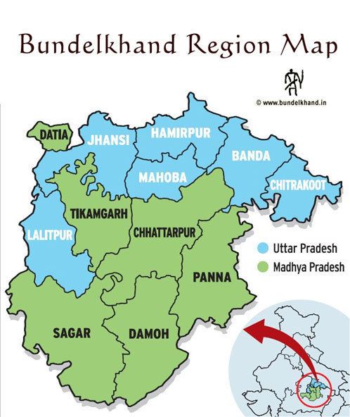
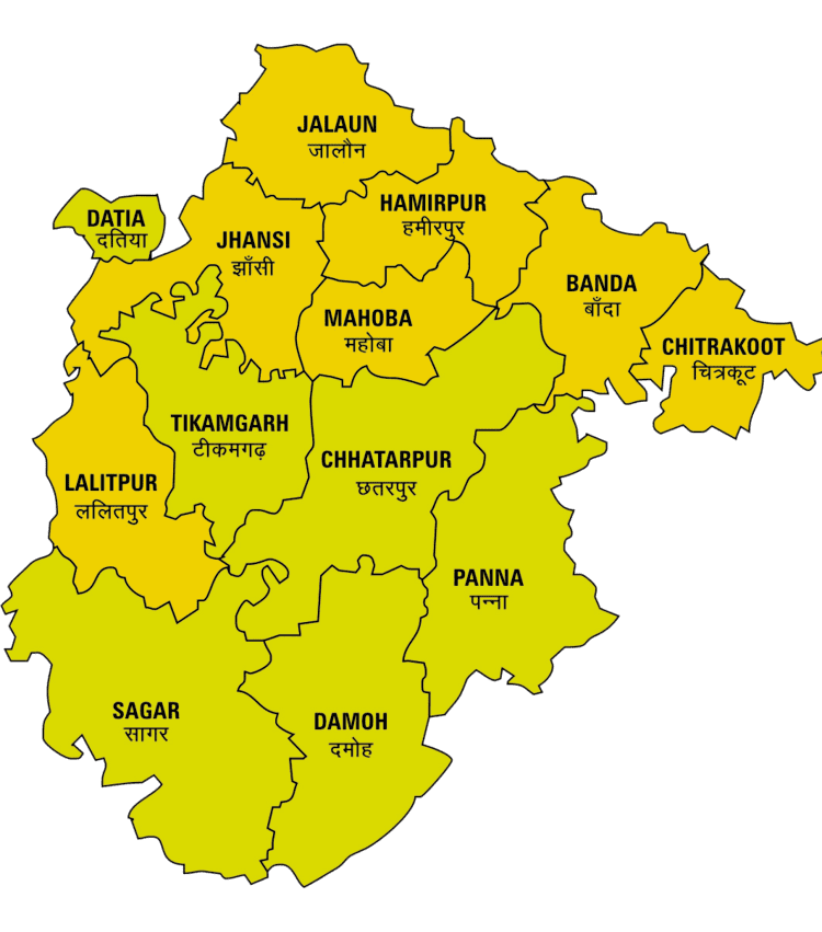
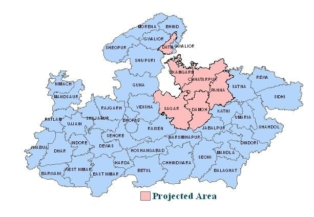
In November 2011 Uttar Pradesh Council of Ministers proposed to split the state into four parts, with one part being Bundelkhand. The proposed state includes the following districts:
In addition to the above districts, sometimes the following districts of Madhya Pradesh & Rajasthan are considered as being part of Bundelkhand:
Culture
The Bundeli language is the most common of the Hindi dialects spoken in the area. It in turn consists of several sub-dialects. The accent varies in various regions even though unmistakably of a single origin.
The region is predominantly Hindu. However, Jainism is historically significant in Bundelkhand, and several Tirthas are located in this region. Many prominent Jain scholars of the 20th century have been from this region.
Folk dances
Bundelkhand has following folk dances. Badhai, Rai, Saira, Jawara, Akhada, Shaitan, Dhimrai.
Radio
A community radio station, Radio Bundelkhand, was launched in Orchha on October 23, 2008. It is an initiative of the Development Alternatives Group. The radio station broadcasts daily programs in the Bundeli dialect and devotes significant amount of its broadcast time to local issues, culture, education and the rich tradition of Bundeli folk music. The station is available on 90.4 MHz.