
Country Russia Settlements 1 Urban-type settlements 1 Founded 10 December 1930 | Rural okrugs 8 Area 223,583 km² | |
 | ||
Administrative center | ||
Bulunsky District (Russian: Булу́нский улу́с; Yakut: Булуҥ улууһа) is an administrative and municipal district (raion, or ulus), one of the thirty-four in the Sakha Republic, Russia. It is located in the north of the republic and borders Ust-Yansky District in the east, Verkhoyansky District in the southeast, Eveno-Bytantaysky and Zhigansky Districts in the south, Olenyoksky District in the west, and Anabarsky District in the northwest. The area of the district is 223,600 square kilometers (86,300 sq mi). Its administrative center is the urban-type settlement of Tiksi. As of the 2010 Census, the total population of the district was 9,054, with the population of Tiksi accounting for 55.9% of that number.
Contents
- Map of Bulunsky District Sakha Republic Russia
- Geography
- Climate
- History
- Administrative and municipal status
- Inhabited localities
- Economy
- Demographics
- References
Map of Bulunsky District, Sakha Republic, Russia
Geography
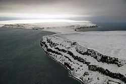
The district is washed by the Laptev Sea in the north. The main river in the district is the Lena. Other rivers include the Olenyok, the Omoloy, and the Khara-Ulakh. There are many lakes in the Lena River delta. The Lena Delta Wildlife Reserve is located in the district.
Climate
Average January temperature varies from −32 °C (−26 °F) on the coast to −40 °C (−40 °F) in the interior and average July temperature varies from +4 °C (39 °F) in the north to +14 °C (57 °F) in the south. Average precipitation ranges from 150 to 200 millimeters (5.9 to 7.9 in) in the north and from 250 to 300 millimeters (9.8 to 11.8 in) in the south.
History
The district was established on December 10, 1930. Initially, its administrative center was in the selo of Kyusyur. In 1957, the administrative center was moved to Tiksi.
Administrative and municipal status
Within the framework of administrative divisions, Bulunsky District is one of the thirty-four in the republic. It is divided into one settlement (an administrative division with the administrative center in the urban-type settlement (inhabited locality) of Tiksi) and eight rural okrugs (naslegs), all of which comprise nine rural localities. As a municipal division, the district is incorporated as Bulunsky Municipal District. The Settlement of Tiksi is incorporated into an urban settlement, and the eight rural okrugs are incorporated into six rural settlements within the municipal district. The urban-type settlement of Tiksi serves as the administrative center of both the administrative and municipal district.
Inhabited localities
*Administrative centers are shown in bold
Economy
The economy of the district is mostly based on reindeer husbandry and fishing. Tiksi is a sea port on the Northern Sea Route.
Demographics
As of the 2002 Census, the ethnic composition was as follows: