
Named for Lord Botetourt Website www.botetourt.org Founded 1770 | Area 1,414 km² Population 33,002 (2013) | |
 | ||
Points of interest Apple Orchard Falls, Roaring Run Furnace, Troutville Park, Greenfield Recreation Park, Hay Rock | ||
Botetourt County (/ˈbɒtətɒt/ BOT-ə-tot) is a United States county that lies in the Roanoke Region of the Commonwealth of Virginia. Located in the mountainous portion of the state, the county is bordered by two major ranges, the Blue Ridge Mountains and the Appalachian Mountains.
Contents
- Map of Botetourt County VA USA
- History
- Geography
- Adjacent counties
- National protected areas
- Major highways
- Demographics
- Board of Supervisors
- Constitutional Officers
- Education
- Politics
- Fire Emergency Medical Services
- Towns
- Census designated places
- Notable people
- References
Map of Botetourt County, VA, USA
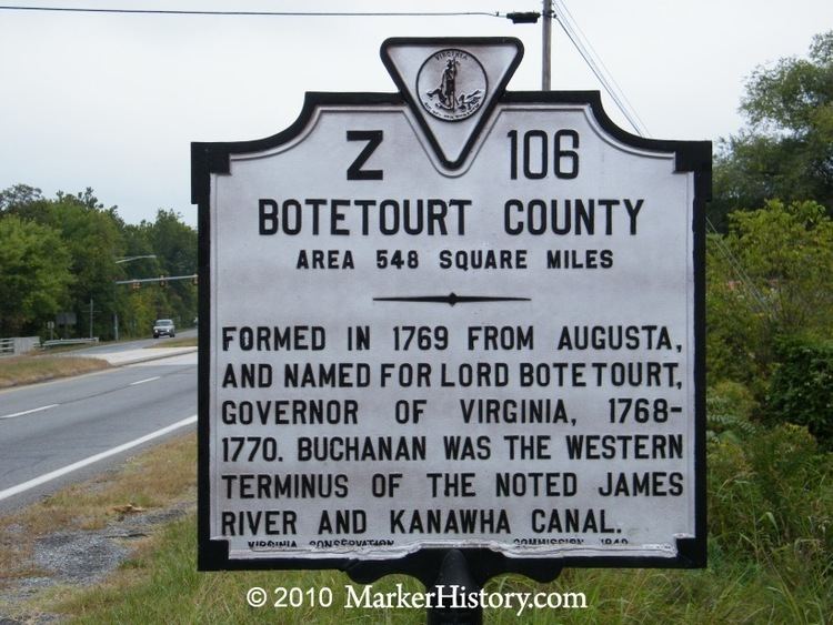
Botetourt County was created in 1770 from part of Augusta County, and was named for Norborne Berkeley, known as Lord Botetourt. Like Augusta County, Botetourt was originally a huge area; part of its land was later removed to form the entire state of Kentucky.
Botetourt County is part of the Roanoke Virginia Metropolitan Statistical Area, and the county seat is the town of Fincastle. As of the 2010 census, the county population was 33,148. The area has seen growth in recent decades, with the population increasing more than thirty percent since the 1990 census.
History
First proposed in the House of Burgesses in 1767, Botetourt County was created in 1770 from Augusta County. The county is named for Norborne Berkeley, Baron de Botetourt, more commonly known as Lord Botetourt (1718–1770), who was a popular governor of the Virginia Colony from 1768 to 1770, when he died suddenly while in office.
In the 1770s, when Virginia claimed most of the Northwest Territory which would later form all or part of six states, the land was initially divided between Botetourt and Augusta Counties. The territory that would eventually become the state of Kentucky was quickly removed from Botetourt, however, and became Fincastle County in 1772 and then Kentucky County in 1776.
Botetourt County is a part of the Roanoke Metropolitan Statistical Area, and the southern parts of the county have become increasingly suburban in recent decades. Much of the area's former farmland and orchards have been developed into residential subdivisions and businesses.
Geography
According to the U.S. Census Bureau, the county has a total area of 546 square miles (1,410 km2), of which 541 square miles (1,400 km2) is land and 4.7 square miles (12 km2) (0.9%) is water. The Blue Ridge Mountains run along the eastern part of the county. The Appalachian Mountains run along the western part of the county. The two mountain ranges come close together, separated by the town of Buchanan and the James River.
The James River originates in Botetourt County, near the village of Iron Gate, just south of the Alleghany County border by the merger of the pristine Cowpasture River and the Jackson River. The James River runs south until Eagle Rock, where it turns east and meanders through the county, passing Springwood and James River High School until entering Buchanan. In Buchanan, the river turns northward and flows into Rockbridge County towards Glasgow.
Adjacent counties
National protected areas
Major highways
Demographics
As of the census of 2000, there were 30,496 people, 11,700 households, and 9,114 families residing in the county. The population density was 56 people per square mile (22/km²). There were 12,571 housing units at an average density of 23 per square mile (9/km²). The racial makeup of the county was 94.91% White, 3.52% Black or African American, 0.22% Native American, 0.47% Asian, 0.19% from other races, and 0.69% from two or more races. 0.59% of the population were Hispanic or Latino of any race.
There were 11,700 households out of which 32.40% had children under the age of 18 living with them, 67.80% were married couples living together, 7.00% had a female householder with no husband present, and 22.10% were non-families. 19.20% of all households were made up of individuals and 7.60% had someone living alone who was 65 years of age or older. The average household size was 2.56 and the average family size was 2.92.
In the county, the population was spread out with 23.40% under the age of 18, 5.80% from 18 to 24, 28.90% from 25 to 44, 28.80% from 45 to 64, and 13.20% who were 65 years of age or older. The median age was 41 years. For every 100 females there were 99.70 males. For every 100 females age 18 and over, there were 98.40 males.
The median income for a household in the county was $48,731, and the median income for a family was $55,125. Males had a median income of $37,182 versus $25,537 for females. The per capita income for the county was $22,218. About 3.60% of families and 5.20% of the population were below the poverty line, including 5.40% of those under age 18 and 6.50% of those age 65 or over.
Board of Supervisors
Amsterdam District: Todd L. Dodson (Vice Chairman) (R)
Blue Ridge District: Billy W. Martin, Sr. (R)
Buchanan District: John Williamson (R)
Fincastle District: L. W. "Jack" Leffel (Chairman) (I)
Valley District: Dr. Donald M. "Mac" Scothorn (R)
Constitutional Officers
Clerk of the Circuit Court: Tommy L. Moore (D)
Commissioner of the Revenue: Rodney Spickard (R)
Commonwealth's Attorney: Joel R. Branscorn (R)
Sheriff: Ronald N. Sprinkle (R)
Treasurer: William P. Arney (R)
Botetourt County is represented by Republican Stephen D. "Steve" Newman in the Virginia Senate, Republicans Chris T. Head and Terry L. Austin in the Virginia House of Delegates, and Republican Robert W. "Bob" Goodlatte in the U.S. House of Representatives.
Education
Botetourt County Public Schools operates public schools serving the county.
There are two high schools in Botetourt County. Lord Botetourt High School opened in suburban Daleville in the fall of 1959. James River High School in Buchanan also opened in 1959.
Politics
The Republican candidate for president has won the support of Botetourt County in 11 of the last 13 races. The county also voted Republican for Governor in 2005 and 2009.
Fire & Emergency Medical Services
Botetourt County Fire & EMS uses a combination of career staff and volunteers to provide fire protection, emergency medical services, fire safety education, swiftwater rescue, and other emergency services to the county. The department operates out of seven stations with a range of fire apparatus and ambulances to provide these services.