
Established 1984 Location Boston, Massachusetts Trail difficulty Easy | Length 47 mi (76 km) Trailheads Numerous access points | |
 | ||
Use Walking, bicycling, inline skating Similar Boston Harbor, Castle Island, Piers Park, Boston Harbor Islands N, Long Wharf | ||
Boston harborwalk timelapse one day in one minute hi def
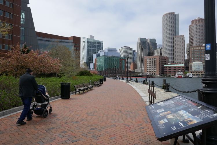
Boston Harborwalk is a public walkway that follows the edge of piers, wharves, beaches, and shoreline around Boston Harbor. When fully completed it will extend a distance of 47 miles (76 km) from East Boston to the Neponset River.
Contents
- Boston harborwalk timelapse one day in one minute hi def
- Map of Boston Harborwalk Charlestown MA 02129 USA
- Boston harborwalk
- History
- Connections to other trails
- Public art
- Historical exhibitions
- East Boston
- North of the Charles River
- Downtown
- South Boston
- On Columbia Point in Dorchester
- Farther south
- Transportation connections
- Future development
- References
Map of Boston Harborwalk, Charlestown, MA 02129, USA
Boston harborwalk
History
The Harborwalk is a cooperative project of the City of Boston, the Boston Planning and Development Agency, the Massachusetts Department of Environmental Protection, The Boston Harbor Association, and private property developers. Since 1984, the project has established parks, walking paths, educational sites, transportation facilities, and other amenities along the harbor. Many developers of private land along the harbor have been required under the provisions of the Boston Zoning Code and of Chapter 91 of Massachusetts state law to set back new buildings from the water and to provide publicly accessible waterfront pathways.
A map of the proposed route shows that the completed Harborwalk will consist of a continuous trail from Charlestown in the north to Dorchester in the south, plus many other discontinuous trail segments. A map and trail guide describe the current status of the route. An interactive map highlights sights along a portion of the walk in downtown Boston. As of 2016, 38 of the originally planned 47 miles of trail have been completed. Following the September 11 attacks, plans to extend the Harborwalk to the four miles of shoreline around Logan Airport were abandoned. As an alternative, planners are now considering an inland route connecting the Harborwalk through the East Boston Greenway to Constitution Beach.
Connections to other trails
The Harborwalk connects with many other trails. From north to south, these include the following:
Public art
Sculptures and memorials, including some by noted artists, have been placed at many locations along the Harborwalk. Playful fish sculpture benches by Judy Kensley McKie and sculptures by Susumu Shingu and David Phillips have been created for Eastport Park, South Boston. Sculptures by Tony Smith, Willem de Kooning, Luis Jimenez, Dennis Oppenheim, William G. Tucker, and Sol LeWitt are located on the University of Massachusetts Boston campus. Between the Institute of Contemporary Art and the John Joseph Moakley United States Courthouse, a series of artworks by Ross Miller evoke moments in the history of Fan Pier. "Untitled Landscape" by David von Schlegell is located at Harbor Towers.
An interactive musical sculpture, "Charlestown Bells," by Paul Matisse (grandson of the painter Henri Matisse) is located along the walkway of the Charles River Dam. The bells were installed in 2000, but had fallen into disrepair before a 2013 restoration.
Memorial sculptures found along the Harborwalk include a memorial to firefighter Robert M. Greene at Castle Island in South Boston; a Korean War Memorial at Shipyard Park in the Boston Navy Yard in Charlestown; and a United States Maritime Service memorial in the North End's Langone Park.
Historical exhibitions
Along the Harborwalk are several indoor and outdoor displays of historical materials, some of which are available for view 24 hours a day. A selection from the archive of Norman B. Leventhal’s collection of Maps of Boston Harbor and Massachusetts Bay is located in the lobby of the Boston Harbor Hotel. In the lobby of Building 114 at the Boston Navy Yard is an exhibition of boat models, photographs and boat building tools. The Maritime Museum at Battery Wharf was built by the developers of the Battery Wharf Hotel as "mitigation" under the state's Chapter 91 law, to compensate the public for private use of waterfront land.
East Boston
North of the Charles River
Downtown
South Boston
On Columbia Point in Dorchester
Farther south
Transportation connections
The Harborwalk is served by many MBTA bus lines. Many public parking lots and garages are nearby. The following subway and commuter rail stops serve the Harborwalk: Maverick Square in East Boston; North Station, Haymarket, Aquarium, and South Station in Downtown Boston; Courthouse, World Trade Center, and Silver Line Way in South Boston; and JFK/UMass and Savin Hill in Dorchester. MBTA Boat services stop at the Navy Yard in Charlestown, at Logan Airport in East Boston, and at Long Wharf and Rowes Wharf downtown.
Future development
New segments continue to be added to the walk as development occurs along the edge of the harbor. A 2012 report prepared for The Boston Harbor Association concluded that approximately 60% of the total possible length of the Harborwalk has been completed.
In March 2016, construction began on a residential building the site of the former Anthony's Pier 4 Restaurant in South Boston. The Harborwalk will extend around the new building.
Another development proposal, on a site adjacent to Pier 4, has been opposed by an environmental group that argues that the proposal's accommodation of the Harborwalk is inadequate.