
 | ||
Fp3 the all new fp3 lofts in boston s fort point channel
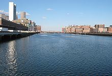
Fort Point Channel is a maritime channel separating South Boston from downtown Boston, Massachusetts, feeding into Boston Harbor. The south part of it has been gradually filled in for use by the South Bay rail yard and several highways (specifically the Central Artery and the Southeast Expressway). At its south end, the channel once widened into South Bay, from which the Roxbury Canal continued southwest where the Massachusetts Avenue Connector is now. The Boston Tea Party occurred at its northern end. The channel is surrounded by the Fort Point neighborhood, which is also named after the same colonial-era fort.
Contents
- Fp3 the all new fp3 lofts in boston s fort point channel
- Map of Fort Point Channel Boston MA USA
- Crossings
- References
Map of Fort Point Channel, Boston, MA, USA
The banks of the channel are still busy with activity. South of Summer Street on the west side of the channel is a large United States Postal Service facility. A large parcel, home to Gillette, lies at the southeast corner of the channel. The back of the Federal Reserve Bank of Boston looks over the channel, and another federal building, the John Joseph Moakley United States Courthouse, lies on Fan Pier at the mouth of the channel. One of Boston's odder attractions, the Hood Milk Bottle, lies on the banks as well, next to Boston Children's Museum. During the 1980s, a nightclub and popular concert venue called The Channel was located on the South Boston bank.
On October 21, 2011, Fort Point Pier opened for public use south of the Summer Street Bridge. To prepare for construction, a fifty-foot section of the Fort Point Channel seawall south of Necco Court was restored by P&G Gillette. Public access has made Fort Point Channel popular for kayaking and standup paddle boarding.
Crossings
The following bridges and tunnels cross or used to cross the channel, from north to south, with building/opening dates:
The channel now ends here; the remaining bridges cross the South Bay Yard.