
Area 12,787 km² Population 4,249 (2013) | Website www.co.custer.id.us Founded 1881 | |
 | ||
Points of interest Williams Peak, Little Redfish Lake, Goat Lake, Marshall Lake, Stanley Lake | ||
Grand view canyon custer county idaho
Custer County is a rural mountain county located in the center of the U.S. state of Idaho. As of the 2010 census, the population was 4,368. The county seat is Challis. Established in 1881, the county was named for the General Custer Mine, where gold was discovered five years earlier. Custer County relies on ranching, mining, and tourism as its main resources.
Contents
- Grand view canyon custer county idaho
- Map of Custer County ID USA
- Geography
- Adjacent counties
- Major highways
- National protected areas
- 2000 census
- 2010 census
- Politics
- Cities
- Unincorporated communities
- Ghost towns
- References
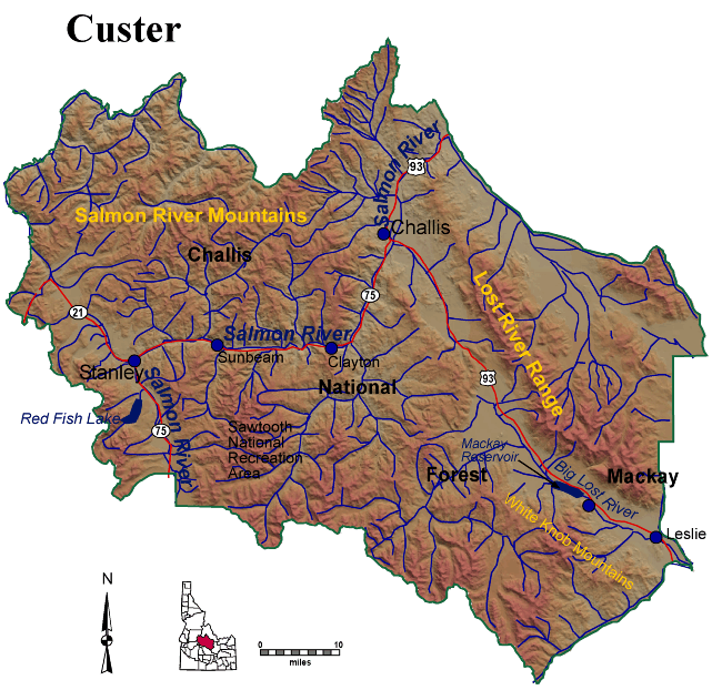
Map of Custer County, ID, USA
Geography
According to the U.S. Census Bureau, the county has a total area of 4,937 square miles (12,790 km2), of which 4,721 square miles (12,230 km2) is land and 16 square miles (41 km2) (0.3%) is water. It is the third-largest county in Idaho by area.
The Lost River Range, the state's highest mountains, are located in eastern Custer County. The highest is Borah Peak, the highest natural point in Idaho at 12,662 feet (3,859 m). On the western border of the county is Idaho's famous Sawtooth Range; the tallest is Thompson Peak in Custer County, above picturesque Redfish Lake. Twenty miles (32 km) east are the White Cloud Mountains, the tallest of which is Castle Peak at 11,815 feet (3,601 m).
The Salmon River and Big Lost River flow through Custer County.
Adjacent counties
Major highways
National protected areas
2000 census
As of the census of 2000, there were 4,342 people, 1,770 households, and 1,196 families residing in the county. The population density was 0.88 people per square mile (0.34/km²). There were 2,983 housing units at an average density of 0.60 per square mile (0.23/km²). The racial makeup of the county was 97.28% White, 0.55% Native American, 0.02% Asian, 0.02% Pacific Islander, 1.17% from other races, and 0.94% from two or more races. 4.21% of the population were Hispanic or Latino of any race. 18.6% were of English, 17.0% German, 10.9% Irish and 9.9% American ancestry according to Census 2000.
There were 1,770 households out of which 29.90% had children under the age of 18 living with them, 60.10% were married couples living together, 4.40% had a female householder with no husband present, and 32.40% were non-families. 27.70% of all households were made up of individuals and 11.30% had someone living alone who was 65 years of age or older. The average household size was 2.41 and the average family size was 2.96.
In the county, the population was spread out with 25.50% under the age of 18, 4.80% from 18 to 24, 25.90% from 25 to 44, 29.30% from 45 to 64, and 14.50% who were 65 years of age or older. The median age was 41 years. For every 100 females there were 104.50 males. For every 100 females age 18 and over, there were 106.80 males.
The median income for a household in the county was $32,174, and the median income for a family was $39,551. Males had a median income of $32,255 versus $21,463 for females. The per capita income for the county was $15,783. About 10.70% of families and 14.30% of the population were below the poverty line, including 16.70% of those under age 18 and 12.80% of those age 65 or over.
2010 census
As of the 2010 United States Census, there were 4,368 people, 1,936 households, and 1,244 families residing in the county. The population density was 0.9 inhabitants per square mile (0.35/km2). There were 3,103 housing units at an average density of 0.6 per square mile (0.23/km2). The racial makeup of the county was 96.4% white, 0.6% American Indian, 0.2% black or African American, 0.2% Asian, 0.1% Pacific islander, 1.5% from other races, and 1.0% from two or more races. Those of Hispanic or Latino origin made up 4.0% of the population. In terms of ancestry, 34.3% were English, 25.6% were German, 19.5% were Irish, and 2.8% were American.
Of the 1,936 households, 24.2% had children under the age of 18 living with them, 55.7% were married couples living together, 4.8% had a female householder with no husband present, 35.7% were non-families, and 30.2% of all households were made up of individuals. The average household size was 2.25 and the average family size was 2.74. The median age was 48.0 years.
The median income for a household in the county was $41,910 and the median income for a family was $56,710. Males had a median income of $42,865 versus $27,317 for females. The per capita income for the county was $22,625. About 10.1% of families and 13.8% of the population were below the poverty line, including 19.2% of those under age 18 and 13.2% of those age 65 or over.
Politics
Custer County is staunchly Republican. In the 2008 Presidential election, it supported Republican John McCain over Democrat Barack Obama by a margin of 71% to 25%. In 2012, Mitt Romney won the Republican primary caucus in the county on the first ballot and voted 74.1% for him in the Presidential election. In 2016, Donald Trump won the Republican primaries with a 41.8% of support in the county even if Ted Cruz won the state with a 45.5%.