
 | ||
Evapotranspiration (ET) is the sum of evaporation and plant transpiration from the Earth's land and ocean surface to the atmosphere. Evaporation accounts for the movement of water to the air from sources such as the soil, canopy interception, and waterbodies. Transpiration accounts for the movement of water within a plant and the subsequent loss of water as vapor through stomata in its leaves. Evapotranspiration is an important part of the water cycle. An element (such as a tree) that contributes to evapotranspiration can be called an evapotranspirator.
Contents
- Water cycle
- Estimating evapotranspiration
- Indirect methods
- Catchment water balance
- Evapotranspiration of Urban Vegetation
- Hydrometeorological equations
- Energy balance
- Experimental methods for measuring evapotranspiration
- Remote sensing
- Eddy covariance
- Urban landscape plants
- Potential evapotranspiration
- References
Reference evapotranspiration (ET0), sometimes incorrectly referred to as potential ET, is a representation of the environmental demand for evapotranspiration and represents the evapotranspiration rate of a short green crop (grass), completely shading the ground, of uniform height and with adequate water status in the soil profile. It is a reflection of the energy available to evaporate water, and of the wind available to transport the water vapour from the ground up into the lower atmosphere. Actual evapotranspiration is said to equal reference evapotranspiration when there is ample water. Some US states utilize a full cover alfalfa reference crop that is 0.5 m in height, rather than the short green grass reference, due to the higher value of ET from the alfalfa reference.
Water cycle
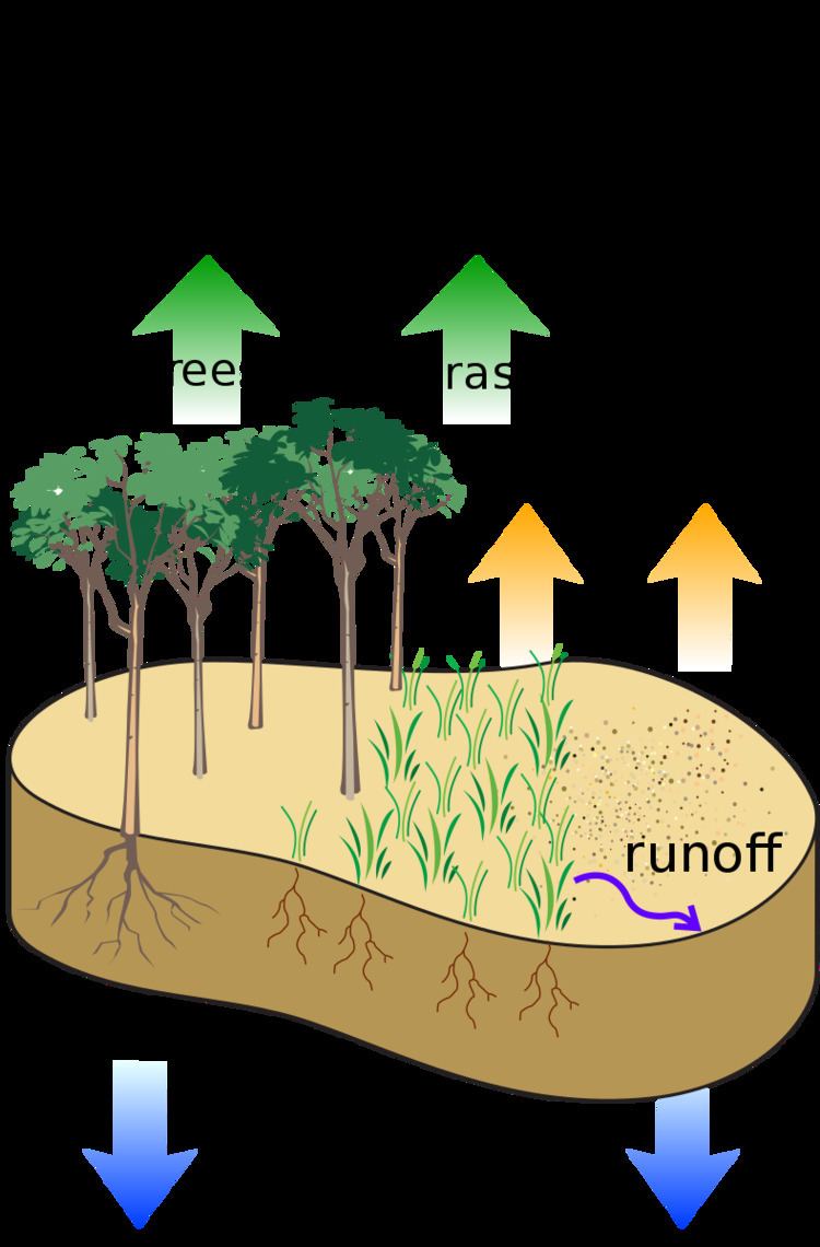
Evapotranspiration is a significant water loss from drainage basins. Types of vegetation and land use significantly affect evapotranspiration, and therefore the amount of water leaving a drainage basin. Because water transpired through leaves comes from the roots, plants with deep reaching roots can more constantly transpire water. Herbaceous plants generally transpire less than woody plants because they usually have less extensive foliage. Conifer forests tend to have higher rates of evapotranspiration than deciduous forests, particularly in the dormant and early spring seasons. This is primarily due to the enhanced amount of precipitation intercepted and evaporated by conifer foliage during these periods. Factors that affect evapotranspiration include the plant's growth stage or level of maturity, percentage of soil cover, solar radiation, humidity, temperature, and wind. Isotope measurements indicate transpiration is the larger component of evapotranspiration.
Through evapotranspiration, forests reduce water yield, except in unique ecosystems called cloud forests. Trees in cloud forests collect the liquid water in fog or low clouds onto their surface, which drips down to the ground. These trees still contribute to evapotranspiration, but often collect more water than they evaporate or transpire.
In areas that are not irrigated, actual evapotranspiration is usually no greater than precipitation, with some buffer in time depending on the soil's ability to hold water. It will usually be less because some water will be lost due to percolation or surface runoff. An exception is areas with high water tables, where capillary action can cause water from the groundwater to rise through the soil matrix to the surface. If potential evapotranspiration is greater than actual precipitation, then soil will dry out, unless irrigation is used.
Evapotranspiration can never be greater than PET, but can be lower if there is not enough water to be evaporated or plants are unable to transpire readily.
Estimating evapotranspiration
Evapotranspiration can be measured or estimated using several methods.
Indirect methods
Pan evaporation data can be used to estimate lake evaporation, but transpiration and evaporation of intercepted rain on vegetation are unknown. There are three general approaches to estimate evapotranspiration indirectly.
Catchment water balance
Evapotranspiration may be estimated by creating an equation of the water balance of a drainage basin. The equation balances the change in water stored within the basin (S) with inputs and outgoes:
The input is precipitation (P) and the outgoes are evapotranspiration (which is to be estimated), streamflow (Q), and groundwater recharge (D). If the change in storage, precipitation, streamflow, and groundwater recharge are all estimated, the missing flux, ET, can be estimated by rearranging the above equation as follows:
Evapotranspiration of Urban Vegetation
The water requirement of urban landscapes, particularly urban parklands, is of growing concern. The estimation of evapotranspiration (ET) and subsequently plant water requirements in urban vegetation needs to consider the heterogeneity of plants, soils, water, and climate characteristics. In a research in South Australia, two practical ET estimation approaches are compared to a detailed Soil Water Balance (SWB) analysis over a one-year period. One approach is the Water Use Classification of Landscape Plants (WUCOLS) method, which is based on expert opinion on the water needs of different classes of landscape plants. The other is a remote sensing approach based on the Enhanced Vegetation Index (EVI) from Moderate Resolution Imaging Spectroradiometer (MODIS) sensors on the Terra satellite. Both methods require knowledge of reference ET calculated from meteorological data. More information is available in:Comparing Three Approaches of Evapotranspiration Estimation in Mixed Urban Vegetation: Field-Based, Remote Sensing-Based and Observational-Based Methods *[1]
Water requirements of urban landscape plants: a comparison of three factor-based approaches*[2]
High Spatial Resolution WorldView-2 Imagery for Mapping NDVI and Its Relationship to Temporal Urban Landscape Evapotranspiration Factors*[3]
Hydrometeorological equations
The most general and widely used equation for calculating reference ET is the Penman equation. The Penman-Monteith variation is recommended by the Food and Agriculture Organization and the American Society of Civil Engineers. The simpler Blaney-Criddle equation was popular in the Western United States for many years but it is not as accurate in regions with higher humidities. Other solutions used includes Makkink, which is simple but must be calibrated to a specific location, and Hargreaves. To convert the reference evapotranspiration to actual crop evapotranspiration, a crop coefficient and a stress coefficient must be used. Crop coefficients referred to in many hydrological models are themselves during periods for which the model is used. This is because crops are seasonal, perennial plants mature over multiple seasons, and stress responses can significantly depend upon many aspects of plant condition.
Energy balance
A third methodology to estimate the actual evapotranspiration is the use of the energy balance.
where λE is the energy needed to change the phase of water from liquid to gas, Rn is the net radiation, G is the soil heat flux and H is the sensible heat flux. Using instruments like a scintillometer, soil heat flux plates or radiation meters, the components of the energy balance can be calculated and the energy available for actual evapotranspiration can be solved.
The SEBAL and METRIC algorithms solve the energy balance at the earth's surface using satellite imagery. This allows for both actual and potential evapotranspiration to be calculated on a pixel-by-pixel basis. Evapotranspiration is a key indicator for water management and irrigation performance. SEBAL and METRIC can map these key indicators in time and space, for days, weeks or years.
Experimental methods for measuring evapotranspiration
One method for measuring evapotranspiration is with a weighing lysimeter. The weight of a soil column is measured continuously and the change in storage of water in the soil is modeled by the change in weight. The change in weight is converted to units of length using the surface area of the weighing lysimeter and the unit weight of water. evapotranspiration is computed as the change in weight plus rainfall minus percolation.
Remote sensing
In recent decades, estimating evapotranspiration has been improved by advances in remote sensing, particularly in agricultural studies. However, quantifying evapotranspiration from mixed vegetation environs, particularly urban parklands, is still challenging because of the heterogeneity of plant species, canopy covers and microclimates and because the methodology is costly. Different remote sensing-based approaches for estimating evapotranspiration have various advantages and disadvantages.
Eddy covariance
The most direct method of measuring evapotranspiration is with the eddy covariance technique in which fast fluctuations of vertical wind speed are correlated with fast fluctuations in atmospheric water vapor density. This directly estimates the transfer of water vapor (evapotranspiration) from the land (or canopy) surface to the atmosphere.
Urban landscape plants
Methods for measuring evapotranspiration can be adapted to an urban setting to estimate the water requirements of urban landscape vegetation.
Potential evapotranspiration
Potential evapotranspiration (PET) is the amount of water that would be evaporated and transpired if there were sufficient water available. This demand incorporates the energy available for evaporation and the ability of the lower atmosphere to transport evaporated moisture away from the land surface. Potential evapotranspiration is higher in the summer, on less cloudy days, and closer to the equator, because of the higher levels of solar radiation that provides the energy for evaporation. Potential evapotranspiration is also higher on windy days because the evaporated moisture can be quickly moved from the ground or plant surface, allowing more evaporation to fill its place.
Potential evapotranspiration is expressed in terms of a depth of water, and can be graphed during the year (see figure).
Potential evapotranspiration is usually measured indirectly, from other climatic factors, but also depends on the surface type, such as free water (for lakes and oceans), the soil type for bare soil, and the vegetation. Often a value for the potential evapotranspiration is calculated at a nearby climate station on a reference surface, conventionally short grass. This value is called the reference evapotranspiration, and can be converted to a potential evapotranspiration by multiplying with a surface coefficient. In agriculture, this is called a crop coefficient. The difference between potential evapotranspiration and precipitation is used in irrigation scheduling.
Average annual potential evapotranspiration is often compared to average annual precipitation, P. The ratio of the two, P/PET, is the aridity index.