
- elevation 336 m (1,102 ft) Basin area 70,614 km² | - elevation 945 m (3,100 ft) Length 861 km Basin area 70,614 km² | |
 | ||
- right Bhama, Indrayani, Mula-Mutha, Nira | ||
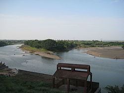
Bhima river on pune solapur route
The Bhima River is a major river in South India. It flows southeast for 861 kilometres (535 mi) through Maharashtra, Karnataka, and Telangana states, before entering the Krishna River. After the first sixty-five kilometers in a narrow valley through rugged terrain, the banks open up and form a fertile agricultural area which is densely populated.
Contents
- Bhima river on pune solapur route
- Map of Bhima River
- Course
- Tributaries
- Bhima basin
- Temples
- Dams
- References
Map of Bhima River
The river is prone to flooding due to heavy rainfall during the monsoon season. In 2005 there was severe flooding in Solapur, Bijapur and Gulbarga districts. The river is also referred to as Chandrabhaga River, especially at Pandharpur, as it resembles the shape of the Moon.
Course
The Bhima River flows southeast for a long journey of 861 kilometres (535 mi), with many smaller rivers as tributaries. It originates near Bhimashankar Temple in the Bhimashankar hills in khed Taluka on the western side of the Western Ghats, known as Sahyadri, in Pune District, Maharashtra state, at 19°04′03″N 073°33′00″E. It flows through Bhimashankar Wildlife Sanctuary where it enters Khed Taluka and is soon joined by its tributary, the Aria River from the right (west) which flows into the Chas Kaman Reservoir. Upstream on the Aria is the Rajgurunagar-Kalmodi Dam impounding the Kalmodi Reservoir. The Chas Kaman Reservoir is impounded by the Chas Kaman Dam, the most upstream dam on the Bhima River proper. The village of Chas is on the left bank some 16 km below the dam. Some 5 km along the river below the bridge on the Bhirma at Chas, the Kumandala River enters from the right. From there it is 8 km along the river to the railroad bridge at the town of Rajgurunagar (Khed) on the left bank. In 18 km further along the river, the Bhima River enters from the right just above the village of Pimpalgaon on the left bank. From there to Siddhegavhan along the river is 10 km. Siddhegavhan is the last village in Khed Taluka on the left.
After leaving Khed Taluka, the Bhima forms the boundary between Havali Taluka on the right (south) and Shirur Taluka on the left (north). From the Bhima's intersection to the Indrayani River, which also enters from the right, is 14 km along the river. At the confluence is the town of Tulapur on the right bank in Havali Taluka. The Bhima River, the Indrayani River and the Mula-Mutha River are the major tributaries of the Bhima that drain western Pune. After the Indrayani, in about 4 km down stream the Dhomal River enters from the right, at the village of Wadhu Budruk. Shortly thereafter (3.5 km) the Bhima passes under the SH 60 bridge at the town of Koregaon Bhima. From Koregaon going east, downstream 16 km, is the confluence with the Vel River (Wel River) from the left (north) and the village of Vittalwadi. The Vel River also arises in Ambegaon Taluka, east of the Bhima, and flows through Khed Taluka and into Shirur Taluka before flowing into the Bhima. With Vittalwadi on the left, the right side of the river leaves Haveli Taluka and enters Daund Taluka.
From Vittalwadi the Bhima meanders northwest and 14 km after the Vel River enters from the left, the Kamania River (Kamina) enters from the left at the village of Parodi. After the Kamania River enters, the river meanders back southeast for 23 km to the confluence with the Mula-Mutha River from the right at the village of Ranjangaon Sandas. The Mula-Mutha River flows from the city of Pune where it is a combination of the Mula River and the Mutha River.
31 km after the Mula-Mutha River, the Ghod River enters from the left (north) across the Bhima from the village of Nanvij (Nanwij). The Ghod River is the last of the Western Ghat tributaries of the Bhima. Shirur Taluka stops at the Ghod River, and Shrigonda Taluka of Ahmednagar District continues on the left (northeast) side of the river. Downstream just 6 km from the Ghod River, is the city of Daund on the right (southwest) bank.
Chandani, Kamini, Moshi, Bori, Sina, Man, Bhogavati_river and Nira are the major tributaries of the river in Solapur District. Of these, the Nira river meets with the Bhima between Nira Narsingpur in Pune District and Malshiras Taluka in Solapur district.
Bhima merges into the Krishna along the border between Karnataka and Telangana about 24 km north of Raichur. At the point where the two rivers meet, the Bhima is actually longer than the Krishna in length.
Tributaries
Bhima basin
The total area of the Bhima basin is 70,614 km². The population living along the banks of Bhima is approximately 12.33 million people (1990) with 30.90 million people expected by 2030. Seventy-five percent of the basin lies in the state of Maharashtra.
Temples
Dams
There are twenty-two dams in basin of Bhima River. The first dam is the Chas Kaman Dam in Khed Taluka, Pune district. The largest dam by capacity is Ujjani Dam, near Tembhurni, Solapur District. Total Water storage capacity of Bhima basin is about 300 TMC in Maharashtra state. Nearly 30 barrages are constructed across the main Bhima river from the downstream of Ujjani dam in Maharashtra and Karnataka states to harness all the water available in the river in excess of Krishna Water Disputes Tribunal allocations. Bhima to Sina interlink (Jod Kalava) with 21 km tunnel from Ujjani reservoir is constructed to supply water for vast lands in catchment area of Sina tributary from main Bhima river.