
Country United States County Hunterdon Incorporated February 21, 1798 Area 53.94 km² Founded 21 February 1798 | Earliest mention 1730 Elevation 192 m Population 3,979 (2010) | |
 | ||
Weather -1°C, Wind NW at 5 km/h, 19% Humidity | ||
Bethlehem Township is a township in Hunterdon County, New Jersey, United States. It is part of the New York metropolitan area. As of the 2010 United States Census, the township's population was 3,979, reflecting an increase of 159 (+4.2%) from the 3,820 counted in the 2000 Census, which had in turn increased by 716 (+23.1%) from the 3,104 counted in the 1990 Census.
Contents
- Map of Bethlehem NJ USA
- History
- Geography
- Mailing addresses
- Climate
- Wildlife and ecosystem
- Census 2010
- Census 2000
- Parks and recreation
- Local government
- Federal state and county representation
- Politics
- Education
- Roads and highways
- Public transportation
- Rail the Lehigh Line
- Notable people
- References
Map of Bethlehem, NJ, USA
History
Bethlehem was first mentioned in official records dating back to 1730, though details of its formation are uncertain. Bethlehem was incorporated as one of New Jersey's initial 104 townships by an act of the New Jersey Legislature on February 21, 1798. Portions of the township were taken to form Kingwood Township (1749, date uncertain), Alexandria Township (March 5, 1765), Union Township (February 17, 1853), Junction borough (February 20, 1895, now known as Hampton borough), Bloomsbury (March 30, 1905) and Glen Gardner (March 26, 1919).
The township was named for the city of Bethlehem.
Geography
According to the United States Census Bureau, the township had a total area of 20.828 square miles (53.944 km2), including 20.711 square miles (53.642 km2) of land and 0.117 square miles (0.303 km2) of water (0.56%). The township is an exurb of New York City, lying on the western fringe of the New York metropolitan area, as part of the Newark-Union, NJ-PA Metropolitan Division, which is in turn a part of the New York City Metropolitan Area.
The Musconetcong River forms the township's northern border with Warren County. The northern half of the Township consists of the Musconetcong Valley while the southern half is covered by the Musconetcong Mountains. The southwest corner of the township lies on what is known as the Hunterdon Plateau.
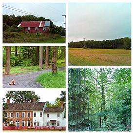
The landscape is mainly rural in nature, featuring farms and forests, scattered with newer housing developments and older farm homes.
Unincorporated communities, localities and place names located partially or completely within the township include Charlestown, Jugtown, Ludlow, Polktown, Swinesburg, Valley and West Portal.
Mailing addresses
Residents and businesses in Bethlehem Township have mailing addresses to nearby towns including Clinton Hampton, Bloomsbury,NJ (and even Asbury, New Jersey which is located in neighboring Warren County), as 'Bethlehem Township' itself is not a mailing address.
Climate
Bethlehem Township falls under the 'Northern New Jersey' climate zone. According to the Office of the New Jersey State Climatologist at Rutgers University, the Northern climate zone covers about one-quarter of New Jersey and consists mainly of elevated highlands and valleys which are part of the Appalachian Uplands. Surrounded by land, this region can be characterized as having a continental climate with minimal influence from the Atlantic Ocean, except when the winds contain an easterly component. Prevailing winds are from the southwest in summer and from the northwest in winter. Being in the northernmost portion of the state, and with small mountains up to 1,800 feet in elevation, the Northern Zone normally exhibits a colder temperature regime than other climate regions of the State of New Jersey. This difference is most dramatic in winter when average temperatures in the Northern Zone can be more than ten degrees Fahrenheit cooler than in the Coastal Zone. Annual snowfall averages 40 to 50 inches in the northern zone as compared with an average of 10-15 inches in the extreme south.
Bethlehem Township falls under the USDA 6b Plant Hardiness zone.
Wildlife and ecosystem
Various animals are native to central-western New Jersey, including red fox (vulpes vulpes), black bear, groundhogs, wild turkeys, deer, squirrels, chipmunks, a variety of birds, and a plethora of insects and vegetation. There are also some fish in the streams of the county.
Trees include deciduous varieties and evergreen varieties.
Black bears are the largest land mammals in New Jersey and are known to be most abundant in the northern-western regions of the state, including Bethlehem Township.
Census 2010
The 2010 United States Census counted 3,979 people, 1,344 households, and 1,148 families residing in the township. The population density was 192.1 per square mile (74.2/km2). The township contained 1,386 housing units at an average density of 66.9 per square mile (25.8/km2). The racial makeup of the township was 95.65% (3,806) White, 0.98% (39) Black or African American, 0.10% (4) Native American, 1.88% (75) Asian, 0.00% (0) Pacific Islander, 0.50% (20) from other races, and 0.88% (35) from two or more races. Hispanics or Latinos of any race were 4.02% (160) of the population.
Out of a total of 1,344 households, 41.1% had children under the age of 18 living with them, 77.0% were married couples living together, 4.8% had a female householder with no husband present, and 14.6% were non-families. 11.9% of all households were made up of individuals, and 5.0% had someone living alone who was 65 years of age or older. The average household size was 2.96 and the average family size was 3.22.
In the township, 27.6% of the population were under the age of 18, 6.2% from 18 to 24, 18.1% from 25 to 44, 38.4% from 45 to 64, and 9.7% who were 65 years of age or older. The median age was 44.2 years. For every 100 females the census counted 100.8 males, but for 100 females at least 18 years old, it was 100.6 males.
The Census Bureau's 2006-2010 American Community Survey showed that (in 2010 inflation-adjusted dollars) median household income was $127,540 (with a margin of error of +/- $12,090) and the median family income was $130,580 (+/- $16,200). Males had a median income of $95,694 (+/- $16,468) versus $70,069 (+/- $27,112) for females. The per capita income for the borough was $44,477 (+/- $4,087). About 0.6% of families and 1.0% of the population were below the poverty line, including 1.1% of those under age 18 and 0.0% of those age 65 or over.
Census 2000
As of the 2000 United States Census there were 3,820 people, 1,266 households, and 1,092 families residing in the township. The population density was 183.3 people per square mile (70.8/km²). There were 1,303 housing units at an average density of 62.5 per square mile (24.1/km²). The racial makeup of the township was 97.51% White, 0.86% African American, 0.10% Native American, 1.02% Asian, 0.05% Pacific Islander, 0.03% from other races, and 0.42% from two or more races. Hispanic or Latino of any race were 1.62% of the population.
There were 1,266 households out of which 43.6% had children under the age of 18 living with them, 80.3% were married couples living together, 3.9% had a female householder with no husband present, and 13.7% were non-families. 10.3% of all households were made up of individuals and 3.3% had someone living alone who was 65 years of age or older. The average household size was 3.02 and the average family size was 3.26.
In the township the population was spread out with 29.5% under the age of 18, 5.0% from 18 to 24, 29.6% from 25 to 44, 29.4% from 45 to 64, and 6.5% who were 65 years of age or older. The median age was 39 years. For every 100 females there were 101.2 males. For every 100 females age 18 and over, there were 99.9 males.
The median income for a household in the township was $88,048, and the median income for a family was $92,768. Males had a median income of $69,063 versus $41,806 for females. The per capita income for the township was $35,298. None of the families and 1.0% of the population were living below the poverty line, including no under eighteens and 10.0% of those over 64.
Most common first ancestries reported in Bethlehem Township were German (25.2%), Italian (14.7%), Irish (14.4%), Polish (9.2%), English (7.6%), United States or American (6.1%), French (except Basque) (3.3%).
Most common places of birth for the foreign-born residents were India (22%), Germany (18%), United Kingdom (12%), Austria (9%), Russia (7%), Poland (5%), Netherlands (4%).
Parks and recreation
Spruce Run State Park and Reservoir, part of the New Jersey State Park system, is located near Bethlehem Township in close-by Clinton Township. It is possible to walk or bike to Spruce Run from Bethlehem Township.
Local government
Bethlehem Township is governed under the Township form of government. The five-member Township Committee is elected directly by the voters at-large in partisan elections to serve three-year terms of office on a staggered basis, with either one or two seats coming up for election each year as part of the November general election in a three-year cycle. At an annual reorganization meeting, the Township Committee selects one of its members to serve as Mayor and another as Deputy Mayor.
As of 2016, members of the Bethlehem Township Committee are Mayor Paul J. Muir (R, term on committee ends December 31, 2017; term as mayor ends 2016), Deputy Mayor Greg Glazar (R, term on committee and as deputy mayor ends 2016), Walter F. Baumgarten (R, 2018), Steve Keefe (R, 2018) and Jose Medeiros (R, 2017; appointed to serve an unexpired term).
In December 2015, the Township Committee chose Jose Medeiros to fill the vacant seat expiring in December 2017 that had been held by John Jimenez.
Bethlehem Township's municipal buildings are located on Mine Road.
Federal, state and county representation
Bethlehem Township is located in the 7th Congressional District and is part of New Jersey's 23rd state legislative district.
New Jersey's Seventh Congressional District is represented by Leonard Lance (R, Clinton Township). New Jersey is represented in the United States Senate by Cory Booker (D, Newark, term ends 2021) and Bob Menendez (D, Paramus, 2019).
For the 2016–2017 session (Senate, General Assembly), the 23rd Legislative District of the New Jersey Legislature is represented in the State Senate by Michael J. Doherty (R, Washington Township, Warren County) and in the General Assembly by John DiMaio (R, Hackettstown) and Erik Peterson (R, Franklin Township, Hunterdon County). The Governor of New Jersey is Chris Christie (R, Mendham Township). The Lieutenant Governor of New Jersey is Kim Guadagno (R, Monmouth Beach).
Hunterdon County is governed by a five-member Board of Chosen Freeholders, who serve three-year terms of office at-large on a staggered basis, with either one or two seats up for election each year on a partisan basis as part of the November general election. At an annual reorganization meeting held each January, the freeholders select one member to serve as the board's Director and another to serve as Deputy Director. As of 2015, Hunterdon County's Freeholders are Freeholder Director John King (R; Raritan Township, 2015), Freeholder Deputy Director Suzanne Lagay (R; Holland Township, 2016), J. Matthew Holt (R; Clinton Town, 2015), John E. Lanza (R; Flemington, 2016) and Robert G. Walton (R; Hampton, 2017). Constitutional officers elected on a countywide basis are County Clerk Mary H. Melfi (R; Flemington, 2017), Sheriff Fredrick W. Brown (R; Alexandria Township, 2016) and Surrogate Susan J. Hoffman (R; Kingwood Township, 2018).
Politics
As of March 23, 2011, there were a total of 2,814 registered voters in Bethlehem Township, of which 514 (18.3%) were registered as Democrats, 1,113 (39.6%) were registered as Republicans and 1,186 (42.1%) were registered as Unaffiliated. There was one voter registered to another party.
In the 2012 presidential election, Republican Mitt Romney received 61.2% of the vote (1,323 cast), ahead of Democrat Barack Obama with 37.0% (800 votes), and other candidates with 1.8% (38 votes), among the 2,172 ballots cast by the township's 2,954 registered voters (11 ballots were spoiled), for a turnout of 73.5%. In the 2008 presidential election, Republican John McCain received 58.9% of the vote here (1,380 cast), ahead of Democrat Barack Obama with 38.2% (896 votes) and other candidates with 2.2% (51 votes), among the 2,343 ballots cast by the township's 2,927 registered voters, for a turnout of 80.0%. In the 2004 presidential election, Republican George W. Bush received 61.6% of the vote here (1,380 ballots cast), outpolling Democrat John Kerry with 37.1% (830 votes) and other candidates with 1.3% (36 votes), among the 2,239 ballots cast by the township's 2,692 registered voters, for a turnout percentage of 83.2.
In the 2013 gubernatorial election, Republican Chris Christie received 73.8% of the vote (985 cast), ahead of Democrat Barbara Buono with 23.1% (309 votes), and other candidates with 3.1% (41 votes), among the 1,349 ballots cast by the township's 2,934 registered voters (14 ballots were spoiled), for a turnout of 46.0%. In the 2009 gubernatorial election, Republican Chris Christie received 66.4% of the vote here (1,130 ballots cast), ahead of Democrat Jon Corzine with 21.9% (373 votes), Independent Chris Daggett with 8.9% (151 votes) and other candidates with 1.2% (20 votes), among the 1,703 ballots cast by the township's 2,855 registered voters, yielding a 59.6% turnout.
Education
Students in public school for kindergarten through eighth grade attend the schools of the Bethlehem Township School District. As of the 2011-12 school year, the district's two schools had an enrollment of 483 students and 48.5 classroom teachers (on an FTE basis), for a student–teacher ratio of 9.96:1. Schools in the district (with 2011-12 enrollment data from the National Center for Education Statistics) are Thomas B. Conley School for grades K - 5 (284 students) and Ethel Hoppock Middle School for grades 6 - 8 (199 students).
Public school students in ninth through twelfth grades attend North Hunterdon High School in Annandale, which also serves students from Clinton Town, Clinton Township, Franklin Township, Lebanon Borough and Union Township. As of the 2014-15 school year, the high school had an enrollment of 1,747 students and 134.8 classroom teachers (on an FTE basis), for a student–teacher ratio of 13.0:1. The school is part of the North Hunterdon-Voorhees Regional High School District, which also includes students from Califon, Glen Gardner, Hampton, High Bridge, Lebanon Township and Tewksbury Township, who attend Voorhees High School.
Roads and highways
As of May 2010, the township had a total of 57.76 miles (92.96 km) of roadways, of which 42.26 miles (68.01 km) were maintained by the municipality, 7.86 miles (12.65 km) by Hunterdon County and 7.64 miles (12.30 km) by the New Jersey Department of Transportation.
Bethlehem Township is well-connected to major metropolitan areas and cities (such as the Lehigh Valley in Pennsylvania and New York City) via Interstate 78 / U.S. 22 and Route 173. While I-78/US 22 pass through without any interchanges, the nearest exit is just outside the township in bordering Bloomsbury (Exit 7) and Union Township (Exit 11).
Anderson Road, located within Bethlehem Township, begins in neighboring Union Township and ends in Bethlehem Township as a dead-end, or cul-de-sac. Consequently, Anderson Road cannot be accessed internally through Bethlehem Township; it can only be accessed through Union Township.
Public transportation
Public transportation is limited to The LINK, a public bus service which serves Hunterdon County. Fares range from about $2.00 to $10.00. Funding for operation of the Hunterdon County LINK System is provided by Hunterdon County, NJ Transit and the Federal Transit Administration.
Rail- the Lehigh Line
The Norfolk Southern Railway's Lehigh Line (formerly the mainline of the Lehigh Valley Railroad), runs through Bethlehem Township on its way to Phillipsburg, New Jersey.
Notable people
People who were born in, residents of, or otherwise closely associated with Bethlehem Township include: