
Country United States County Hunterdon Local time Monday 9:04 AM Population 1,060 (2013) | Incorporated April 2, 1918 Elevation 146 m Zip code 07830 | |
 | ||
Area rank 502nd of 566 in state23rd of 26 in county Weather -2°C, Wind W at 3 km/h, 35% Humidity | ||
Califon is a borough in Hunterdon County, New Jersey, United States. As of the 2010 United States Census, the borough's population was 1,076, reflecting an increase of 21 (+2.0%) from the 1,055 counted in the 2000 Census, which had in turn declined by 18 (-1.7%) from the 1,073 counted in the 1990 Census.
Contents
- Map of Califon NJ 07830 USA
- History
- Geography
- Census 2010
- Census 2000
- Local government
- Federal state and county representation
- Politics
- Education
- Transportation
- Notable people
- References
Map of Califon, NJ 07830, USA
The town was to originally have been called California, but the name was shortened to Califon in order to fit on the welcome sign. Alternatively, the name was related to a bright yellow cattle feed sold during the Gold Rush.
History
Califon was a station on the High Bridge Branch of the Central Railroad of New Jersey. The rail line was abandoned in 1976 and now serves as a Hunterdon County-administered rail trail called Columbia Trail, which runs south to High Bridge and north to points in Morris County.
Though the mills were present in the area of Califon for some time prior to its incorporation as a town, it was quite a while before growth became evident in the mid-nineteenth century. It was first called California, from Jacob Neighbor's enthusiasm in the milling business about the time the California Gold Rush broke out. The Borough was incorporated by an act of the New Jersey Legislature from portions of both Lebanon and Tewksbury Townships on April 2, 1918.
Local legend has it that California became a regular stop for weekend excursion trains through the countryside. When riders bought their tickets they were issued a voucher good for an ice cream; the train would stop so tourists could wander around and cash in their ice cream coupons. Anxious to exploit this source of outside revenue, residents petitioned the railroad to let them build a real station, which they did as a community project. Citing the local account again, two sign painters who came to letter the sign rode the train from Dunellen, but the background paint wasn't dry when they arrived. They sat and drank at the hotel, which later burned down. By the time the sign was ready for their artistic touch, the local tale says, "Califon" was as close to California as the inebriated painters could manage.
Califon is situated just north of the Ken Lockwood Gorge on the South Branch of the Raritan River; this pristine stretch of clear water and forest is a well-known treasure for New Jersey trout fishermen.
The Califon Historic District is a 164-acre (66 ha) historic district that was listed on the National Register of Historic Places in 1976. It included 154 contributing buildings, three contributing structures, and one contributing site, created through the efforts of the Califon Historical Society. Califon is a Victorian-style enclave where the houses are marked with the names of the builders and their dates of establishment rather than with street numbers.
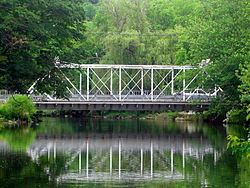
The center of Califon is the historic iron bridge spanning the South Branch of the Raritan River, which divides the borough. Recently the State of New Jersey announced that the bridge would be replaced because a loaded school bus represented more weight than the aging bridge could safely carry. Incensed citizens objected, protective of the landmark, and found a colorful but simple solution; the school bus stops at one end of the bridge unloading the students, who then walk across to the other side. Then the empty bus, within imposed weight limits, drives across and the students get back on the bus to continue their ride. Thus the bridge was saved. (Account featured on Califon website).
Califon became a regional household name when frequently mentioned by Merv Griffin on his TV show during the 1970s. He and his wife Juliette owned a home in nearby Lebanon Township, which had a Califon mailing address, and, while they were married, they were often seen visiting the village in a fringed-top Bermuda-style resort cart. Califon Productions created all of his television ventures.
The Hoffmans were a family of German farmers who to this day are remembered by the bridge and section south of Califon known as Hoffman's Crossing. Thomas B. Hoffman farmed land that lies just south of Califon Bridge, along present day Route 513.
Geography
According to the United States Census Bureau, the borough had a total area of 0.972 square miles (2.518 km2), including 0.949 square miles (2.459 km2) of land and 0.023 square miles (0.059 km2) of water (2.36%).
Califon borders the Hunterdon County municipalities of Lebanon Township and Tewksbury Township.
Lower Valley is an unincorporated community located along the border of Califon and Lebanon Township.
Census 2010
The 2010 United States Census counted 1,076 people, 394 households, and 308.9 families residing in the borough. The population density was 1,133.3 per square mile (437.6/km2). The borough contained 419 housing units at an average density of 441.3 per square mile (170.4/km2). The racial makeup of the borough was 96.10% (1,034) White, 0.28% (3) Black or African American, 0.09% (1) Native American, 0.84% (9) Asian, 0.00% (0) Pacific Islander, 0.09% (1) from other races, and 2.60% (28) from two or more races. Hispanics or Latinos of any race were 1.30% (14) of the population.
Out of a total of 394 households, 40.1% had children under the age of 18 living with them, 67.8% were married couples living together, 7.6% had a female householder with no husband present, and 21.6% were non-families. 17.8% of all households were made up of individuals, and 5.6% had someone living alone who was 65 years of age or older. The average household size was 2.73 and the average family size was 3.14.
In the borough, 28.2% of the population were under the age of 18, 4.8% from 18 to 24, 22.6% from 25 to 44, 34.9% from 45 to 64, and 9.6% who were 65 years of age or older. The median age was 41.9 years. For every 100 females the census counted 93.5 males, but for 100 females at least 18 years old, it was 88.5 males.
The Census Bureau's 2006-2010 American Community Survey showed that (in 2010 inflation-adjusted dollars) median household income was $108,375 (with a margin of error of +/- $9,026) and the median family income was $110,365 (+/- $5,782). Males had a median income of $95,536 (+/- $13,555) versus $73,958 (+/- $14,845) for females. The per capita income for the borough was $42,975 (+/- $5,250). About 1.7% of families and 2.4% of the population were below the poverty line, including 0.8% of those under age 18 and 0.0% of those age 65 or over.
Census 2000
As of the 2000 United States Census there were 1,055 people, 401 households, and 301 families residing in the borough. The population density was 1,093.2 people per square mile (419.9/km2). There were 410 housing units at an average density of 424.9 per square mile (163.2/km2). The racial makeup of the borough was 98.67% White, 0.76% Asian, and 0.57% from two or more races. Hispanic or Latino of any race were 0.47% of the population.
There were 401 households out of which 36.7% had children under the age of 18 living with them, 68.8% were married couples living together, 4.5% had a female householder with no husband present, and 24.7% were non-families. 21.2% of all households were made up of individuals and 8.7% had someone living alone who was 65 years of age or older. The average household size was 2.63 and the average family size was 3.11.
In the borough the population was spread out with 26.8% under the age of 18, 4.1% from 18 to 24, 30.6% from 25 to 44, 27.9% from 45 to 64, and 10.6% who were 65 years of age or older. The median age was 39 years. For every 100 females there were 91.5 males. For every 100 females age 18 and over, there were 90.1 males.
The median income for a household in the borough was $76,657, and the median income for a family was $85,963. Males had a median income of $59,167 versus $41,125 for females. The per capita income for the borough was $31,064. About 3.3% of families and 4.3% of the population were below the poverty line, including 2.5% of those under age 18 and 14.8% of those age 65 or over.
Local government
Califon is governed under the Borough form of New Jersey municipal government. The governing body consists of a Mayor and a Borough Council comprising six council members, with all positions elected at-large on a partisan basis as part of the November general election. A Mayor is elected directly by the voters to a four-year term of office. The Borough Council consists of six members elected to serve three-year terms on a staggered basis, with two seats coming up for election each year in a three-year cycle. The Borough form of government used by Califon, the most common system used in the state, is a "weak mayor / strong council" government in which council members act as the legislative body with the mayor presiding at meetings and voting only in the event of a tie. The mayor can veto ordinances subject to an override by a two-thirds majority vote of the council. The mayor makes committee and liaison assignments for council members, and most appointments are made by the mayor with the advice and consent of the council.
As of 2016, the Mayor of Califon Borough is Democrat Charles Daniel, whose term of office ends December 31, 2018. Members of the Califon Borough Council are Council President Gill Smith (R, 2017), Megan Riccio (2017), Kathleen DeBlasio (2016), Tony Forrester (2016), Leo M. Janas (2018) and Michael Medea (2018).
Federal, state and county representation
Califon is located in the 7th Congressional District and is part of New Jersey's 23rd state legislative district. Prior to the 2011 reapportionment following the 2010 Census, Califon had been in the 24th state legislative district.
New Jersey's Seventh Congressional District is represented by Leonard Lance (R, Clinton Township). New Jersey is represented in the United States Senate by Cory Booker (D, Newark, term ends 2021) and Bob Menendez (D, Paramus, 2019).
For the 2016–2017 session (Senate, General Assembly), the 23rd Legislative District of the New Jersey Legislature is represented in the State Senate by Michael J. Doherty (R, Washington Township, Warren County) and in the General Assembly by John DiMaio (R, Hackettstown) and Erik Peterson (R, Franklin Township, Hunterdon County). The Governor of New Jersey is Chris Christie (R, Mendham Township). The Lieutenant Governor of New Jersey is Kim Guadagno (R, Monmouth Beach).
Hunterdon County is governed by a five-member Board of Chosen Freeholders, who serve three-year terms of office at-large on a staggered basis, with either one or two seats up for election each year on a partisan basis as part of the November general election. At an annual reorganization meeting held each January, the freeholders select one member to serve as the board's Director and another to serve as Deputy Director. As of 2015, Hunterdon County's Freeholders are Freeholder Director John King (R; Raritan Township, 2015), Freeholder Deputy Director Suzanne Lagay (R; Holland Township, 2016), J. Matthew Holt (R; Clinton Town, 2015), John E. Lanza (R; Flemington, 2016) and Robert G. Walton (R; Hampton, 2017). Constitutional officers elected on a countywide basis are County Clerk Mary H. Melfi (R; Flemington, 2017), Sheriff Fredrick W. Brown (R; Alexandria Township, 2016) and Surrogate Susan J. Hoffman (R; Kingwood Township, 2018).
Politics
As of March 23, 2011, there were a total of 723 registered voters in Califon, of which 214 (29.6%) were registered as Democrats, 252 (34.9%) were registered as Republicans and 257 (35.5%) were registered as Unaffiliated. There were no voters registered to other parties.
In the 2012 presidential election, Democrat Barack Obama received 51.0% of the vote (290 cast), ahead of Republican Mitt Romney with 47.3% (269 votes), and other candidates with 1.8% (10 votes), among the 573 ballots cast by the borough's 773 registered voters (4 ballots were spoiled), for a turnout of 74.1%. In the 2008 presidential election, Democrat Barack Obama received 51.1% of the vote (324 cast), ahead of Republican John McCain with 46.4% (294 votes) and other candidates with 1.7% (11 votes), among the 634 ballots cast by the borough's 792 registered voters, for a turnout of 80.1%. In the 2004 presidential election, Republican George W. Bush received 51.2% of the vote (330 ballots cast), outpolling Democrat John Kerry with 47.2% (304 votes) and other candidates with 1.3% (10 votes), among the 644 ballots cast by the borough's 796 registered voters, for a turnout percentage of 80.9.
In the 2013 gubernatorial election, Republican Chris Christie received 62.4% of the vote (237 cast), ahead of Democrat Barbara Buono with 35.3% (134 votes), and other candidates with 2.4% (9 votes), among the 383 ballots cast by the borough's 774 registered voters (3 ballots were spoiled), for a turnout of 49.5%. In the 2009 gubernatorial election, Republican Chris Christie received 55.4% of the vote (251 ballots cast), ahead of Democrat Jon Corzine with 30.5% (138 votes), Independent Chris Daggett with 12.1% (55 votes) and other candidates with 0.9% (4 votes), among the 453 ballots cast by the borough's 772 registered voters, yielding a 58.7% turnout.
Education
The Califon School District serves students in public school for pre-kindergarten through eighth grade at Califon Public School. As of the 2014-15 school year, the district and its one school had an enrollment of 179 students and 15.4 classroom teachers (on an FTE basis), for a student–teacher ratio of 11.6:1.
Public school students in ninth through twelfth grades attend Voorhees High School, which also serves students from Glen Gardner, Hampton, High Bridge, Lebanon Township and Tewksbury Township. As of the 2014-15 school year, the high school had an enrollment of 1,067 students and 88.4 classroom teachers (on an FTE basis), for a student–teacher ratio of 12.1:1. The school is part of the North Hunterdon-Voorhees Regional High School District, which also includes students from Bethlehem Township, Clinton Town, Clinton Township, Franklin Township, Lebanon Borough and Union Township who attend North Hunterdon High School in Annandale.
Transportation
As of May 2010, the borough had a total of 11.50 miles (18.51 km) of roadways, of which 9.50 miles (15.29 km) were maintained by the municipality and 2.00 miles (3.22 km) by Hunterdon County.
Notable people
People who were born in, residents of, or otherwise closely associated with Califon include: