
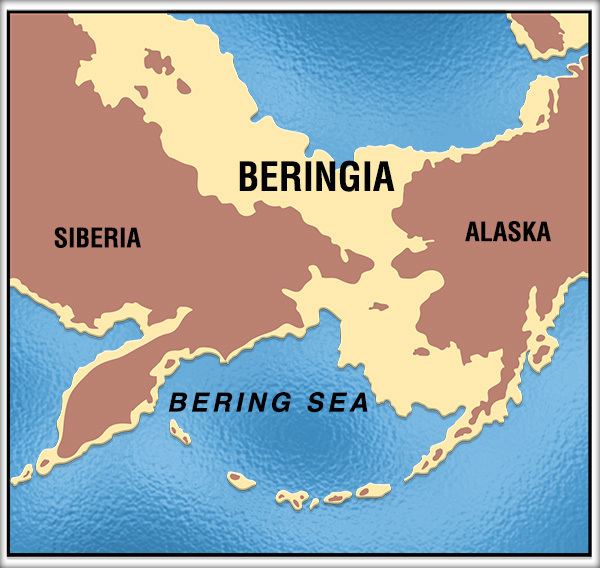
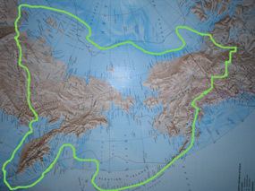
Beringia is defined today as the land and maritime area bounded on the west by the Lena River in Russia; on the east by the Mackenzie River in Canada; on the north by 72 degrees north latitude in the Chukchi Sea; and on the south by the tip of the Kamchatka Peninsula. It includes the Chukchi Sea, the Bering Sea, the Bering Strait, the Chukchi and Kamchatka Peninsulas in Russia as well as Alaska in the United States.
Contents
The area includes land lying on the North American Plate and Siberian land east of the Chersky Range. Historically, it formed a land bridge that was up to 1,000 kilometres (620 miles) wide at its greatest extent and which covered an area as large as British Columbia and Alberta together, totaling at approximately 1,600,000 square kilometres (620,000 square miles). Today, the only land that is visible from the central part of the Bering land bridge are the Diomede Islands, the Pribilof Islands of St. Paul and St. George, St. Lawrence Island, and King Island.
The term Beringia was coined by the Swedish botanist Eric Hultén in 1937. During the ice ages, Beringia, like most of Siberia and all of North and Northeast China, was not glaciated because snowfall was very light. It was a grassland steppe, including the land bridge, that stretched for hundreds of kilometres into the continents on either side.
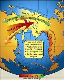
It is believed that a small human population of at most a few thousand arrived in Beringia from eastern Siberia during the Last Glacial Maximum before expanding into the settlement of the Americas sometime after 16,500 years ago during the Late Glacial Maximum as the American glaciers blocking the way southward melted, but before the bridge was covered by the sea about 11,000 years BP.
Before European colonization, Beringia was inhabited by the Yupik peoples on both sides of the straits. This culture remains in the region today along with others. In 2012, the governments of Russia and the United States announced a plan to formally establish "a transboundary area of shared Beringian heritage". Among other things this agreement would establish close ties between the Bering Land Bridge National Preserve and the Cape Krusenstern National Monument in the United States and the planned Beringia National Park in Russia.
Geography
The remains of Late Pleistocene mammals that had been discovered on the Aleutians and islands in the Bering Sea at the close of the nineteenth century indicated that a past land connection might lay beneath the shallow waters between Alaska and Chukotka. The underlying mechanism was first thought to be tectonics, but by 1930 changes in the icemass balance, leading to global sea-level fluctuations, was viewed as the cause of the Bering Land Bridge. In 1937, Eric Hultén proposed that around the Aleutians and the Bering Strait region were tundra plants that had originally dispersed from a now-submerged plain between Alaska and Chukotka, which he named Beringia after Vitus Bering who had sailed into the strait in 1728. The American arctic geologist David Hopkins redefined Beringia to include portions of Alaska and Northeast Asia. Beringia was later regarded as extending from the Verkhoyansk Mountains in the west to the Mackenzie River in the east. The distribution of plants in the genera Erythranthe and Pinus are good examples of this as genera members are found in Asia and the Americas with a high degree of similarity.
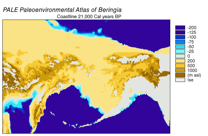
During the Pleistocene epoch, global cooling led periodically to the expansion of glaciers and lowering of sea levels. This created land connections in various regions around the globe. Today, the average water depth of the Bering Strait is 40–50 m (130–160 ft), therefore the land bridge opened when the sea level dropped more than 50 m (160 ft) below the current level. A reconstruction of the sea-level history of the region indicated that a seaway existed from c. 135,000 – c. 70,000 BP, a land bridge from c. 70,000 – c. 60,000 BP, intermittent connection from c. 60,000 – c. 30,000 BP, a land bridge from c. 30,000 – c. 11,000 BP, followed by a Holocene sea-level rise that reopened the strait. Post-glacial rebound has continued to raise some sections of coast.

During the last glacial period, enough of the earth's water became frozen in the great ice sheets covering North America and Europe to cause a drop in sea levels. For thousands of years the sea floors of many interglacial shallow seas were exposed, including those of the Bering Strait, the Chukchi Sea to the north, and the Bering Sea to the south. Other land bridges around the world have emerged and disappeared in the same way. Around 14,000 years ago, mainland Australia was linked to both New Guinea and Tasmania, the British Isles became an extension of continental Europe via the dry beds of the English Channel and North Sea, and the dry basin of the South China Sea linked Sumatra, Java, and Borneo to Indochina.
Beringian refugium
Reconstructions of the Late Pleistocene palaeoenvironment of Beringia indicate that it had a relatively moist climate dominated by a shrub–tundra habitat that was very different from the dry environments on either side of it, forming an ecological refugium. Beringia's closeness to the sea created intermittent maritime cloud cover, which caused an interruption to the dry and cold Mammoth steppe. Even in the driest and coldest periods of the Late Pleistocene, and possibly during the entire Pleistocene, moisture occurred along a north-south gradient with the south receiving the most cloud cover and moisture due to the air-flow from the North Pacific.
In the Late Pleistocene, Beringia was a mosaic of biological communities. Commencing from c. 57,000 BP (MIS 3), steppe–tundra vegetation dominated large parts of Beringia with a rich diversity of grasses and herbs. There were patches of shrub tundra with isolated refugia of larch (Larix) and spruce (Picea) forests with birch (Betula) and alder (Alnus) trees. It has been proposed that the largest and most diverse megafaunal community residing in Beringia at this time could only have been sustained in a highly diverse and productive environment. Analysis at Chukotka on the Siberian edge of the land bridge indicated that from c. 57,000 – c. 15,000 BP (MIS 3 to MIS 2) the environment was wetter and colder than the steppe–tundra to the east and west, with warming in parts of Beringia from c. 15,000 BP. These changes provided the most likely explanation for mammal migrations after c. 15,000 BP, as the warming provided increased forage for browsers and mixed feeders. Beringia did not block the movement of most dry steppe-adapted large species such as saiga antelope, woolly mammoth, and caballid horses. However, from the west the woolly rhino went no further east than the Anadyr River, and from the east North American camels, the American kiang-like equids, the short-faced bear, bonnet-horned muskoxen, and badger did not travel west. At the beginning of the Holocene, some mesic habitat-adapted species left the refugium and spread westward into what had become tundra-vegetated northern Asia and eastward into northern North America.
The latest emergence of the land bridge was c. 70,000 years ago. However, from c. 24,000 – c. 13,000 BP the Laurentide ice sheet fused with the Cordilleran ice sheet, which blocked gene flow between Beringia (and Eurasia) and continental North America. The Yukon corridor opened between the receding ice sheets c. 13,000 BP, and this once again allowed gene flow between Eurasia and continental North America until the land bridge was finally closed by rising sea levels c. 10,000 BP. During the Holocene, many mesic-adapted species left the refugium and spread eastward and westward, while at the same time the forest-adapted species spread with the forests up from the south. The arid adapted species were reduced to minor habitats or became extinct.
Beringia constantly transformed its ecosystem as the changing climate affected the environment, determining which plants and animals were able to survive. The land mass could be a barrier as well as a bridge: during colder periods, glaciers advanced and precipitation levels dropped. During warmer intervals, clouds, rain and snow altered soils and drainage patterns. Fossil remains show that spruce, birch and poplar once grew beyond their northernmost range today, indicating that there were periods when the climate was warmer and wetter. The environmental conditions were not homogenous in Beringia. Recent stable isotope studies of woolly mammoth bone collagen demonstrate that western Beringia (Siberia) was colder and drier than eastern Beringia (Alaska and Yukon), which was more ecologically diverse. Mastodons, which depended on shrubs for food, were uncommon in the open dry tundra landscape characteristic of Beringia during the colder periods. In this tundra, mammoths flourished instead.
The extinct pine species Pinus matthewsii has been described from Pliocene sediments in the Yukon areas of the refugium.
The paleo-environment changed across time. Below is a gallery of some of the plants that inhabited eastern Beringia plains prior to the beginning of the Holocene.
Human habitation
The Bering land bridge is a postulated route of human migration to the Americas from Asia about 20,000 years ago. An open corridor through the ice-covered North American Arctic was too barren to support human migrations before around 12,600 BP. A study has indicated that of the people who migrated across this land bridge at that time, only 70 left their genetic imprint on modern descendants, which is known as a founder effect (this is easily misread as implying that only 70 people crossed to North America).
Seagoing coastal settlers may also have crossed much earlier, but there is no scientific consensus on this point, and the coastal sites that would offer further information now lie submerged in up to a hundred metres of water offshore. Land animals migrated through Beringia as well, introducing to North America species that had evolved in Asia: mammals such as proboscideans and American lions, which evolved into now-extinct endemic North American species; and allowing equids and camelids that had evolved in North America (and later became extinct there) to migrate to Asia.
A study published in 2007 suggests that the Bering land bridge migration occurred 12,000 BP, that every human who migrated across the land bridge came from Eastern Siberia, and that every indigenous person directly descends from that same group of Eastern Siberian migrants. The authors note that a "[u]nique genetic variant widespread in natives across both continents suggests that the first humans in the Americas came in a single migration or multiple waves from a single source, not in waves of migrations from different sources".
Previous connections
Biogeographical evidence demonstrates previous connections between North America and Asia. Similar dinosaur fossils occur both in Asia and in North America. For instance the dinosaur Saurolophus was found in both Mongolia and western North America. Relatives of Troodon, Triceratops, and even Tyrannosaurus rex all came from Asia.
Fossils in China demonstrate a migration of Asian mammals into North America around 55 million years ago. By 20 million years ago, evidence in North America shows a further interchange of mammalian species. Some, like the ancient saber-toothed cats, have a recurring geographical range: Europe, Africa, Asia, and North America. The only way they could reach the New World was by the Bering land bridge. Had this bridge not existed at that time, the fauna of the world would be very different.
Researchers have started to use molecular phylogenetics to trace the history of faunal exchange and diversification, through the genetic history of parasites and pathogens of North American ungulates. An international Beringian Coevolution Project is collaborating to provide material to assess the pattern and timing of faunal exchange and the potential impact of past climatic events on differentiation.