
Country France Population (2010) 230 Area 10.86 km² | Canton La Conca-d'Oro Time zone CET (UTC+1) Local time Thursday 8:24 AM | |
 | ||
Weather 9°C, Wind W at 16 km/h, 64% Humidity | ||
Barbaggio is a French commune in the Haute-Corse department of France on the island of Corsica. It is known for its wine, its scenery, and the prehistoric site of Strette.
Contents
- Map of 20253 Barbaggio France
- Geography
- Relief
- Hydrography
- Climate and vegetation
- Road access
- Town planning
- Prehistory
- Middle Ages
- Modern Times
- Battle of the Col de Teghime
- Post War
- Administration
- Demography
- Economy
- Civil heritage
- Religious Heritage
- Environmental heritage
- Notable people linked to the commune
- References
Map of 20253 Barbaggio, France
Geography
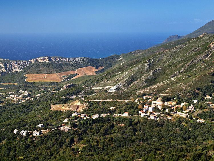
Barbaggio is located on an inland plateau below Cap Corse on the southwest slopes of the 960 metres (3,150 ft) high Serra di Pigno some 8 km east of Saint-Florent and 5 km south-east of Patrimonio. In times of conflict it controls the Col de Teghime, a 536-metre (1,759 ft) high pass through the Serra mountains leading to Bastia, 10 kilometres (6 mi) to the north-east. Barbaggio has a fine view of the Golfe de St-Florent but does not itself border the sea. Traditionally an area belonging to the Nebbio region, which has been called since Antiquity Conca d'Oro. Barbaggio is one of 8 communes that make up the current Canton of La Conca-d'Oro.
Relief
Barbaggio backs onto the western slope of the mountains of the Serra di Pigno, the extension of the dorsal schist of Cap Corse. It covers the plain to the south-west of the village. The eastern side is delineated by the valley of the Ruisseau de Lucitello stream with the village built on a rocky ridge under the Pigno (958 m).
Its boundaries are defined as follows:
Barbaggio does not border the sea - the bridge on the D81 is located approximately 700 m from the sea.
The plateau is drained by small streams such as the Ruisseau de Lucitello and provides the commune with its chief economic resource: 45 hectares (110 acres) of grapevines. The commune is known for its fine wine. Of the 1,086 ha (2,680 acres) remainder, 610 ha (1,500 acres) are woods. Barbaggio shares a nature reserve of 32 ha (79 acres) with nearby Oletta.
Hydrography
Barbaggio is located in the drainage basin of the Ruiseau de la Trutta which flows west to Olzu in the Gulf of Saint-Florent. Upstream it is called the Ruisseau de Vaccareccia. It rises from the Cima di Malaspina at 470 m above sea level. It is fed by the Ruisseau de Natio Creek (upstream called Ruisseau de Lucitello) and its tributary the Ruisseau de Forci.
Climate and vegetation
As for other communes in the Nebbio region and those along the western coast of Cap Corse, Barbaggio enjoys a Mediterranean climate with moderate temperature changes. The snow only reaches the heights of Pigno a few days a year, rarely dropping below 400 metres. Snowfall disrupts traffic in the Col de Teghime (536 m above sea level) only rarely.
Rainfall that should refresh the Serra di Pigno is low in summer and so the flanks of the mountain are arid, sunny, and exposed, being the sulana (or sunny-side) of the mountain and subject to frequent libeccio - the prevailing westerly wind: dry, violent, and often mixed with the punente, the other westerly wind. Because of its geographical position and its area of plain, Barbaggio is relatively well protected from the north winds - the Tramuntana in winter: a healthy, dry, violent and icy wind; and the wet winter north-Easter which brings cold and snow from Italy.
The vegetative cover in uncultivated areas has different landscapes at different levels. Near the ridges vegetation is low moorish carved by strong winds with rocky grasslands. On lower levels it is dense maquis shrubland consisting of many thorny shrubs (Thorny broom and Corsican broom) as well as brambles , Pouzin rosebushes (Rosa pouzinii), and Sarsaparille which are often impenetrable and without trees due to frequent fires. At the level of the village there are olive trees, Holly Oaks, and even some chestnuts. Around the village are palm trees, mimosas, prickly pears, and agaves which bring an exotic touch.
The cultivated areas are located on the plain. They are mostly vines producing wines and muscat under an AOC. In peak summer season they have a supply of water from Lake Padula .
Road access
The D81 road from Bastia to Saint-Florent passes through the commune and crosses the Col de Teghime (536 m). Descending from the pass, Barbaggio is the first of the two villages that are located on the route.
The Col de Teghime in the south of the commune is the junction of the D81 and the D38 which goes south-west to Poggio-d'Oletta.
The D338 road leads to the top of Pigno, south-east of the commune, where there are telecommunication towers. Its junction with the D81 is nearly 700 m east of the Col de Teghime. It ends in a cul-de-sac in remote Pigno with the telecommunications facilities at 4.1 km.
Town planning
The village of Barbaggio is built on a rocky ridge under the Pigno (958 m). There are three other hamlets in the commune:
The plain is occupied by isolated farms.
The houses have austere facades without balconies and are 2 or 3 levels. Most are rendered and restored. Roofs alternate between slate and red tiles.
There is an orientation table at the village and at the Col de Teghime where the views are superb over the Gulf of Saint-Florent, the mountains of Nebbio, and the sunny limestone slopes covered with vineyards. At Pigno the view is spectacular: on one side is the Tyrrhenian Sea and the islands of the Tuscan archipelago, and on the other is the Gulf of Saint-Florent, the Agriates, and almost all of Nebbio.
Prehistory
The rivulets that drain the plateau beneath Barbaggio and nearby Patrimonio gather into a single stream, the Ruisseau la Strutta or Rivière de la Strutta which, flowing between 200-metre (660 ft) cliffs, crosses a short alluvial plain and empties into the Gulf of Saint Florent. Route D81 leaving Saint-Florent bears north-east along the alluvium and turns inland through the gorge. Just over the Barbaggio border at the base of a cliff is the prehistoric Abri de Strette meaning "Strette Shelter" where strette means "narrow place". It is one of the oldest continuously occupied sites in Corsica.
The material of the bottom layer has been carbon-dated to 9140±300 BP or about 7000 BC which is well into the Pre-Neolithic period. It contains shell middens and the bones of small animals, such as Sardinian pika, believed to be extinct, as well as a lithic assemblage. Chemical analysis of the stones identifies them as non-Corsican. This level is believed to have been a seasonal hunter-gatherer site of non-Corsicans arriving by boat.
The Early Neolithic period, starting about 6000 BC, is identified by shards of Cardium Pottery. Subsequent layers indicate a continuous occupation until the end of the Bronze Age; i.e., this was an indigenous village commanding the route to the plateau and the pass. It was abandoned at the start of the Iron Age but was sporadically occupied afterwards.
In 1965 a Statue menhir in perfect condition was discovered near a place called Foata on the plain of Barbaggio. It was named U Nativu.
In 1985 the area where U Nativu had been discovered was converted into a sports field. An urgent rescue excavation was carried out by J-G. Ottaviani and J. Magdeleine. The seven trenches dug led to the discovery of three blocks of Miocene limestone (the rock from which U Nativu was cut) proving the likelihood that several stones were cut in very ancient times.
Since then the U Nativu has been displayed at Patrimonio and is now called "de Patrimonio".
Middle Ages
In the Middle Ages Barbaggio, then Barbaio − belonged to the Diocese of Nebbio, (From the Latin Nebulensis meaning "cloudy"), which consisted of a section of north-west Corsica and the south-west coast of Cap Corse. These facts are attested by the Cartulary of Nebbio, a fragment of a 13th-century collection of documents published by the bishops of Nebbio concerning the notarization of land titles from the 10th to the 13th centuries AD. One of the notaries was Johannes de S. Martino de Barbaio, a priest. The language of the document shows that the Corsican language had already evolved from Latin.
Modern Times
In the 16th century the Pieve of Patrimonio was made up of inhabited places called: lo Palazzo, la Ficagia, la Picinasca, lo Cardeto, lo Calvello, la Feruciasca, Barbagio, Brigheta, and Casatico. Around 1550 the Pieve had about 550 inhabitants.
At the time of the Great Revolt of the Corsicans against the Genoese (1729-1769) Antoine Dominic Monti, in his chronology of events, reported the following on the participation of the people of Barbaghju against the occupying Genovese:
In the 18th century, when Corsica was ceded to France by the Genovese, the Pieve took the name of Pieve d'Olmeta. At the French Revolution in 1789, the pievi became cantons. The piève for Barbaggio became the Canton of Saint-Florent.
Battle of the Col de Teghime
On 3 October 1943 the Col de Teghime was the scene of a battle between the German forces defending the pass against the 2nd group of Moroccan tabors, who landed in the Gulf of Saint Florent commanded by Lieutenant-Colonel Pierre Boyer de Latour Moulin. The few German fortifications at this strategic point were removed at the cost of heavy fighting with knives.
To commemorate the feat of arms a monument was erected on the side of the D81 road and a gun (possibly of Russian origin) was placed there.
The town of Barbaggio honoured Pierre Boyer de Latour Moulin by giving his name to the village square.
Post-War
In 1954 the Canton of Saint-Florent was formed with the communes of Farinole, Patrimonio, Saint-Florent, and Barbaggio, which then had 104 inhabitants.
In 1971-1973, new cantons were created. The Canton of La Conca-d'Oro was created with the merger of the former cantons of Oletta and Saint-Florent.
Administration
List of Successive Mayors
(Not all data is known)
Demography
In 2010 the commune had 230 inhabitants. The evolution of the number of inhabitants is known from the population censuses conducted in the commune since 1793. From the 21st century, a census of communes with fewer than 10,000 inhabitants is held every five years, unlike larger communes that have a sample survey every year.
Sources : Ldh/EHESS/Cassini until 1962, INSEE database from 1968 (population without double counting and municipal population from 2006)
Economy
Viticulture is the chief industry of Barbaggio. Vines have been grown on terraced hillsides there and in most other villages of the wine-making region of Cap Corse since antiquity, possibly since prehistory. The wine industry of France in recent times is regulated by a governmental system of certification called the Appellation d'origine contrôlée (AOC), which specifies where and under what conditions the grapes for its labels can be grown. Barbaggio is certified to make the following labels:
These are high-quality light table wines of minimal aging and short life made from grapes grown by several land-owners of the region.
Barbaggio is also the source stone blocks for the creation or strengthening of breakwaters, used in the port of Bastia and the Marina of Toga, and also for the construction of walls and parapets of all types. Two old open quarries are no longer used with those next to the D81 having been rehabilitated. The old quarry next to the D38 on the slopes of Monte Secco produced stone for masonry in irregular sizes but with a naturally smooth face of ochre/brown.
The quarry at Ponte Fesso, which produces very large metagabbros, may be extended to meet demand. The deposit consists of metagabbros in leptynite veins.