
Traversed by U.S. Forest Route 23 Elevation 1,326 m | Coordinates Mapper_ | |
 | ||
Location Skamania County, Washington, U.S. | ||
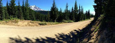
Babyshoe Pass, is a high pass within United States National Forests. Forest Route 23 traverses the pass, northwest of Mount Adams in the State of Washington, between Mount Adams flank to the east and Babyshoe Ridge to the west. The pass separates the Lewis River Watershed and the Cispus River drainage. It was built to connect a Forest Highway (Forest Route 23) together, providing the main north-south access on the east side of the Gifford Pinchot National Forest and the many trails within or around the Mount Adams Wilderness and the Midway High Lakes Area.
Contents
Map of Babyshoe Pass, Washington, USA
LocationEdit
It is located at 4,350 feet (1,330 m) along with Primary Forest Route 23, between the Primary Forest Route 90 junction and the Primary Forest Route 21 junction. The pass is located in the Midway High Lakes Area of Mount Adams, offering five high elevation lakes within a seven-mile radius. The most popular being Takhlakh Lake.