
Length 61 km | Basin size 307 km (119 sq mi) | |
 | ||
Main source Gaillefontaine160 m (520 ft) Discharge Average rate:2.9 m/s (100 cu ft/s) | ||
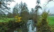
The Béthune is a river of Normandy, France, 61 kilometres (38 mi) in length, flowing through the department of Seine-Maritime and it is a tributary of the Arques River. The French Sandre regulators however, consider the Béthune as the Arques for all its length.
Contents
Map of La B%C3%A9thune, Arques-la-Bataille, France
GeographyEdit
The river’s source is at the village of Gaillefontaine near to Forges-les-Eaux. Its valley is wholly within the pays de Bray. Its course takes it past the communes of Neufchâtel-en-Bray, Mesnières-en-Bray, Bures-en-Bray, Osmoy-Saint-Valery, Saint-Vaast-d'Équiqueville, Dampierre-Saint-Nicolas, Saint-Aubin-le-Cauf and finally Arques-la-Bataille where it joins the Eaulne and the Varenne Rivers to form the Arques River
Like other rivers in the region, the Béthune is classified as a first class river, offering anglers the chance to catch salmon and trout.