
Postal code 55xx – 59xx Area 5,630 km² | Area rank 7th in Hungary Area code(s) (+36) 66, 68 | |
 | ||
University Kodolányi János University College Points of interest Arboretum of Szarvas, Mini Hungary, Almásy‑kastély, Gyulai Vár és Várkilátó, Wenckheim Palace Szabadkígyós Destinations | ||
Békés County (Hungarian: Békés megye), is an administrative division (county or megye) in south-eastern Hungary, on the border with Romania. It shares borders with the Hungarian counties Csongrád, Jász-Nagykun-Szolnok, and Hajdú-Bihar. The capital of Békés county is Békéscsaba. The county is also part of the Danube-Kris-Mures-Tisa euroregion.
Contents
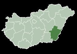
- Map of BC3A9kC3A9s County Hungary
- Etymology
- Geography
- Neighbours
- History
- Demographics
- Ethnicity
- Religion
- Politics
- Municipalities
- City with county rights
- Towns
- Villages
- Notable people
- International relations
- References
Map of B%C3%A9k%C3%A9s County, Hungary
Etymology
In Slovak, it is known as Békešská župa and in Romanian as Județul Bichiș.
After Hungarians conquered the area, Békés and its surroundings were the property of the Csolt clan. Békés (the name means "peaceful") was originally the name of the castle which gave its name to the comitatus, and, like many castles, was possibly named after its first steward.
Geography
This county has a total area of 5,630 km2 (2,174 sq mi) – 6,05% of Hungary.
Békés county lies on the Pannonian Plain (Great Plain), it is a flat area with good soil. Average rainfall is 645 mm/year. One-fifth of the natural gas resources of Hungary can be found in Békés. The river Körös runs through the county.
Neighbours
History
The area has been inhabited since 5000-4000 BC. Before the arrival of the Hungarians several other tribes lived in the area.
The castle of Gyula was built in the early 15th century. Gyula was the most significant town of the county at that time, and became county seat under Matthias I. It was an important fortress during the Ottoman wars in Europe but it was captured in 1566. During this time, several towns were destroyed in the area.
In the early 18th century, after the Ottomans were expelled, the county was repopulated, not only with Hungarians, but with Slovaks (in the towns Békéscsaba, Endrőd, Szarvas, Tótkomlós), Serbs (Battonya), Germans (Németgyula, Elek), and Romanians (Kétegyháza). Most of the non-Magyar population was assimilated by the mid-19th century.
The agricultural importance of the county and the new railway line between Pest and Békéscsaba (finished in 1858) brought development, which was quickened when Hungary lost its southern territories to Romania after World War I and Békéscsaba had to take over the role of the lost cities.
The population growth peaked in 1950 (472,000), in the same year when Békéscsaba became the county seat. During the following years, the county was industrialized, like most of Hungary, and the population of the cities and towns grew.
Demographics
In 2015, it had a population of 351,148 and the population density was 62/km².
More than 60% of the population lives in towns.
Ethnicity
Besides the Hungarian majority, the main minorities are the Roma (approx. 9,500), Slovaks (7,500), Romanians (5,000), Germans (2,500), and Serbs (500).
Total population (2011 census): 359,948
Ethnic groups (2011 census): Identified themselves: 325,597 persons:
Approx. 53,000 persons in Békés County did not declare their ethnic group at the 2011 census.
Religion
Religious adherence in the county according to 2011 census:
Politics
The Békés County Council, elected at the 2014 local government elections, is made up of 18 counselors, with the following party composition:
Municipalities
The regional structure of Békés county is typical of the Great Plain: it has a small number of villages, but those are large, both by area and by population. There are several farmsteads as well. 70% of the population lives in cities and towns, while 17% are in the county seat. A large village network is characteristic of the county which currently has 75 administratively independent settlements, of which 19 are cities and 56 are villages. The oldest towns, and with the largest populations, are: Békéscsaba, the county seat - a city carrying a rank of county right, Orosháza, Gyula, Békés, and Szarvas.
City with county rights
Towns
(ordered by population, as of 2011 census)
Villages
municipalities are large villages.
Notable people
Natives of the county include:
International relations
Békés County has a partnership relationship with: